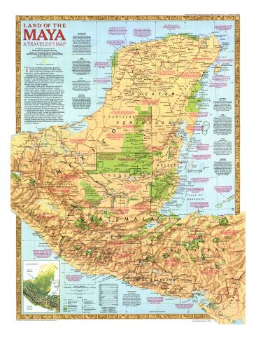
The 1989 Land of the Maya map features:
• Historical notes about Mayan culture and the pyramids, monuments and other architecture they left behind including information on nine Mayan cities
• Mayan language groups
• National parks, existing protected areas, and proposed protected areas
• Ruins, populated places of archaeological importance, points of interest, and museums
• Paved roads, unpaved roads, railroads, sacbe (Maya causeway), and airports
• Small physical map of the region
• Geographical equivalents
* Lesson plan idea - have your students update the information and latest disoveries concerning the Mayan civilization; discuss the political, economic, and environmental situations that are current for the region. • maps
The very word Maya evokes images of mystery–ancient pyramids soaring above trackless jungle, giant carved stones proclaiming artistc and intellectual prowess, a sudden and enigmatic demise.
Sometime before A.D. 250–uring the period known to archaeologists as the Preclassic–the first Mesoamerican culture that we can confidently call Maya borrowed ideas from neighbors, added its own ingredients, and created one of the most brilliant civiliations of antiquity amid the rain forest in the heart of Yucatan Peninsula.
In the ensuing Classic period, Maya society endured for nearly six centuries as a dynamic population of nobles, priests, scribes, artists, craftsmen, warriors, and farmers locate in cities ruled by hereditary dynasts who claimed divine ancestry. The still unexplained collapse of this world–perhaps hastened by agricultural failure due to climate change and the population pressure of as many as 16 million people–was countered by the increasing strength of cultures to the west. The Postclassic period (circa 900-1500) saw the rise of new centers of power, along with expanded trade routes and a new elite. Artifacts suggest a more cosmopolitan society but one still fairly grounded in traditional ways. The arrival of the Spaniards in the first decades of the 16th century violently closed this chapter of Maya civilization.
Yet the Maya live today. At least four million descendants still speak the Mayan languages. though most are now Roman Catholic, they share the ancient myths and practice rituals based on the ancestral view of the cosmos. Despite centuries of often forced change, the Maya continue to leave an indelible mark on eastern Mesoamerica where the culture was born so long ago.
CHICHEN ITZA - 20º41'N; 88º34'W
A Late Classic center, this Maya city became an important capital between the 10th and 12th centuries A.D. The city's art and architecture reflect both Maya and foreign elements, traditionally seen as a result of invasion by Toltecs from central Mexico. Recent work suggests that this style is instead a local Maya development, tempered by increased traffic with Mexicans in the late Classic and Early Postclassic eras. The famous Sacred Cenote, a large natural well, was the focus of offerings to the rain god–pottery, incense, jewelry, and even humans were sacrificed.
COBA - 20º30'N; 87º44'W
One of the largest of ancient Maya cities flourished during the Late Classic and much of the Postclassic period. The ruins, located among shallow lakes, include a well-preserved system of raised stone causeways, called sacbeob, which connected suburban and downtown areas or lead to distant cities. The ancient sacbe linking Coba and Yuxuna, a hundred kilometers awy, it the longest known.
UXMAL - 20º23'N; 89º46'W
Symbolism related to the cycles of the planet Venus, serpents, and great long-nosed countenances of the rain god, Chac, decorated the intricate mosaic on the upper facades of temples and places in Uxmal, largest of the many Classic/Postclassic cities of the Puuc, or hills, region.
PALENQUE - 17º30'N; 92º02'W
Prized for its well-preserved buildings, carved stucco ornamentation, delicate bas-reliefs, and lengthy hieroglyphic texts, this Classic period city reached its zenith during the reign of Pacal the Great (A.D. 615-683). His tomb in the Temple of the Inscriptions, opened in 1952, stands as one of the greatest discoveries of Maya archaeology.
CALAKMUL - 18º05'N; 89º49'W
At least 106 carved stelae–more than at any other knownsite–were erected by rulers of this regional capital between A.D. 500 and 850. Distinguished by huge early structures and an area of some 70 square kilometers, Calakmul thrived during the Late Preclassic and Classic periods.
TIKAL - 17º12'N; 89º38'W
Intensive construction took place at Tikal from Late Preclassic times until the waning of Classic Maya civilization around A.D. 900. The city at its peak covered an area of some 120 square kilometers and held a population estimated at 55,000. Tikal Stela 29 bears the earliest Long Count date known in the Maya lowlands–A.D. 292. Temple IV, one of many temple-pyramids erected to memorialized the dead rulers of Tikal's royal dynasty, rises 65 meters, one of the tallest ancient structures in the New World.
COPAN - 14º52'N; 89º08'W
The southernmost major center of lowland Maya civilization is famed for its sculpture. The great Hieroglyphic Stairway, dedicate in A.D. 755, bears a continuous text of at least 1,250 glyph blocks listing dates and names of the city's Classic period rulers. More than a century of archaeological research has provided a detailed view of the rise and fall of the city center and the valley population it dominated.
QUIRIGUA - 15º16'N; 89º02'W
This strategically located river city of the Classic period controlled the important Motugua Valley trade route linking the Caribbean coast with interior highlands and lowlands. Remarkably preserved portraits and texts of sandstone stelae chronicle a rulling dynasty in competition with nearby Copan In A. D. 737 the ruler Cauac Sky captured and beheaded Copan's lord, 18 Rabbit.
KAMINALJUYU - 14º37'N; 90º34'W
Huge earthen mounds mark this former capital and trade hub. Late Preclassic monumental sculptures reflect the Izapan art style, linking early Pacific coast peoples with the Maya lowland to the north. Architectrual style and tomb contents of the Early Classic period indicate strong links to distant Teotihuacn, some 1,060 kilometers to the northwest.