|
|
|
|
|
|
|
|
|
|
|
|
BOOKS ABOUT CITIES & URBAN PLANNING
|
|
|
|
|
|
|
|
|
|
|
|
|
|
|
|
 |
|
|
|
|
|
|
|
|
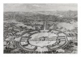
French architect Claude Nicolas Ledoux proposed a grandiose ideal city for the Royal Saltworks at Arc-et-Senans, or Salines de Chaux. In addition to the city being built near the forest that would supply the fuel for the drying pans of saline water that flowed to the works by canal, the shape of the buildings would explain their identify and function, i.e. the hoop makers houses were shaped as barrels.
• perspective posters
|
|
|
|
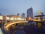
Chengdu, one of the most important economic, transportation, and communication centers in Western China, has been the site of human habitation for 4,000 years.
|
|
|
|
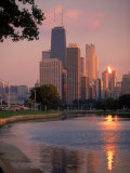
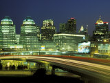
Chicago, Illinois, is the third most populous city in the USA, after New York City and Los Angeles. The town of Chicago was organized in 1833 and incorporated in 1837.
Chicago is located on the far southwestern shore of Lake Michigan, near a natural portage between the Great Lakes and the Mississippi River watershed.
The poet Carl Sandberg called Chicago the “Hog Butcher for the World/Tool Maker, Stacker of Wheat/Player with Railroads and the Nation's Freight Handler,/Stormy, Husky, Brawling, City of the Big Shoulders.”
|
|
|
|
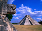
Chichen Itza, meaning “at the mouth of the well of the Itza”, was a major area of settlement for the Maya. Chichen Itza is located in the northern center of the Yucatan Peninsula in Mexico.
Natural sink holes, called cenotes, probably provided plentiful water year round, in an otherwise arid landscape.
• more Chichen Itza
|
|
|
|
Chisinau, the capital and largest city of Moldova, was founded as a monastery village in 1436.
Chisinau was the site of a large anti-Semitic riot in the early 20th century and nearly destroyed by WWII and a major earthquake in 1940. Today Chisinau an educational and industrial center for Moldova.
|
|
|
|
Chongqing, one of the five national central cities of the People's Republic of China, is possibly the world's largest municipality by population and one of the largest by area.
|
|
|
|
Cincinnati, settled in 1788, is located to north of the Ohio River at the Ohio-Kentucky border, near Indiana.
The name Cincinnati comes from Cincinnatus who was regarded as a hero by the Romans for stepping out from being a farmer and leading the armies – the Americans had formed the Society of Cincinnati to honor George Washington. |
|
|
previous page | top | next
Cities of the World | a | b | Ca-Cap | Car | Cas-Cay | CH-CI | Co | Cu-Cy | d | e-f |
g | h | i | j | k | l | m | n | o | p | q | r | s | t | u | v | w | x-y-z
|
|
I have searched the web for visual, text, and manipulative curriculum support materials - teaching posters, art prints, maps, charts, calendars, books and educational toys featuring famous people, places and events - to help teachers optimize their valuable time and budget.
Browsing the subject areas at NetPosterWorks.com is a learning experience where educators can plan context rich environments while comparing prices, special discounts, framing options and shipping from educational resources.
Thank you for starting your search for inspirational, motivational, and educational posters and learning materials at NetPosterWorks.com. If you need help please contact us.
|
|
|