|
|
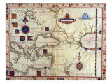
Isthmus and Straits of the World Posters, Prints, Charts
for oceanography and marine environment, ecology, and geography educators & classrooms.
|
science > oceans > water > ISTHMUS & STRAITS < landforms < geography < social studies
|
|
An isthmus relatively narrow strip of land (with water on both sides) connecting two larger land areas. Isthmus (singular isthmi) are land bridges, when they inhibit shipping it is common to dig a canal through the isthmus. The word isthmus is from the Ancient Greek meaning “neck”.
A strait or straits is a narrow, navigable channel of water that connects two larger navigable bodies of water. Straits are econonmically important as shipping routes: if the naturally occurring strait did not exist then a canal or channel would likely be constructed to enable a shorter route.
Isthmuses and straits are locations of great strategic value. Straits also create the potential for restricting free access between large bodies of water thus setting the stage for wars over the control of passage.
A sound is a narrow ocean channel (or large ocean inlet).
|
|
|
|
|
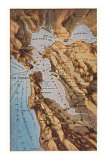
Gibraltar is the name of a strait, a peninsula and a monolithic limestone promontory, the Rock of Gibraltar, located between the Atlantic Ocean and the Mediterranean Sea.
The Iberian Peninsula and Spain are to the north, Morocco and Africa are to the south.
In ancient times the Rock of Gibraltar (Roman, Mons Calpe) and its companion mount on the African side of the Strait, Mons Abyla or Jebel Musa, were known as the Pillars of Hercules, marking the end of the known world.The Rock of Gibraltar is one of the Pillars of Hercules (Roman, Mons Calpe
Gibraltar, as a political entity, is an overseas territory of the United Kingdom.
|
|
|
|
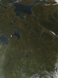
The area between the Black and Caspian Seas, known as the Caucasus, fills the definition of an isthmus. The topography of the Caucasus is mountainous, a meeting point of Europe and Asia, with a diversity of peoples and languages.
|
|
|
|
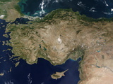
The continents of Europe and Asia are separated by the Strait of Bosphorus linking the Black Sea and the Sea of Mamara and the Dardanelles from the Mamara to the Aegean Sea arm of the Mediterranean Sea (upper left corner of image to the left).
The strategic importance of the water passage between continents has made the Bosphorus and the Dardanelles the site of Greek myths and great battles of world history.
The Bosphorus, the world's narrowest strait used in international navigation, divides the city of Istanbul, founded by the Emperor Constantine, and formerly known as Constantinople.
|
|
|
|
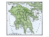
The Isthmus of Corinth connected the Peloponnese peninsula with the rest of the mainland of Greece. In 1893 the Corinth Canal was cut through making the Peloponnese an island.
The ancient city-state of Corinth was located on the isthmus, and Paul wrote two letter, epistles, to the Christian community at Corinth (1 & II Corinthians).
|
|
|
|
The Isthmus of Karelian is the connection between Finland and Russia. The city of St. Petersburg lies on the isthmus on the shores of Bay of Vyborg which is part of the Gulf of Finland.
|
|
|
|
|
|
|
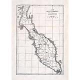
The Isthmus of Kra, the narrow land bridge which connects the Malay Peninsula with the mainland of Asia, is called “The Devil's Neck”.
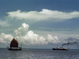
The Malacca Strait, between the Malay Peninsula and the Indonesian island of Sumatra, is the main shipping channel connecting the Indian and Pacific Oceans.
The city of Singapore, located at the southern tip of the Malay Peninsula, is also near the Phillips Channel, a significantly narrow point in the strait and site of international attention.
|
|
|
|
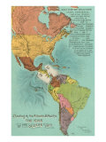
Isthmus of Panama lies between the Caribbean Sea and the Pacific Ocean and linked North and South America.
The country of Panama and the Panama Canal are on the isthmus.
|
|
|
|
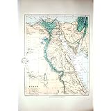
Isthmus of Suez is the land connection between the continents of Africa and Asia.
In the 1860s, at the northern end of the Gulf of Suez, the isthmus was cut by the Suez Canal from the Red Sea the Mediterranean Sea, eliminating the need to sail around the Cape of Good Hope at the southern tip of Africa.
|
|
|
|
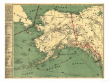
The Bering (sometimes Behring) Strait between the easternmost point of the Asian continent and the westernmost point of the North American continent connects the Arctic Ocean with the Pacific Ocean.
It is theorized that hunter-gatherers walked into North America via the Bering Land Bridge during a past ice age.
The straits are named for Vitus Bering, a Danish explorer in service to the Russian Navy, who visited the area in 1728.
|
|
|
|
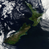
Cook Strait is the water passage between the North and South Islands of New Zealand, connecting the Tasman Sea on the west with the South Pacific Ocean on the east.
The strait is named after James Cook, the first European explorer to sail through it, in 1770, though it was sighted by Abel Tasman in 1642, who thought it was a “bight”.
The Maori name Raukawa or Raukawa Moana may mean “bitter leaves”.
|
|
|
|
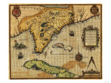
The Florida Strait between the peninsula of Florida and the island of Cuba connects the Gulf of Mexico to the Atlantic Ocean.
|
|
|
|
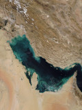
The very narrow (21 miles) Strait of Hormuz connects the Indian Ocean and the Persian Gulf in Southwest Asia. On the north coast is Iran with the United Arab Emirates on the south coast, and with 20% of the world's oil passing through, it is one of the most sensitive geographic areas in the world.
Muscat, the capital and largest city in Oman, lies on the Arabian Sea along the Gulf of Oman near the Straits of Hormuz.
FYI ~ William Baffin, best remembered for exploring the Arctic Circle, also surveyed the Red Sea and the Persian Gulf, dying at the Strait of Hormuz.
|
|
|
|
|
|
|
The strait at Dover (51º1'17"N 1º28'38"E) is the narrowest point in the English Channel, separating the British Isles from the European mainland by 21 miles. It is noted for the White Cliffs of Dover on the English side, and the Cap Blanc Nez on the French side - the remnants of the land bridge that eroded away.
|
|
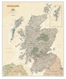
An example of a strait from northern Scotland is the Pentland ‘Firth’ which separates the Orkney Islands from Caithness.
|
|
|
|
|
|
|
|
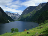
The Strait(s) of Magellan, a navigable sea route immediately south of mainland South America and north of the archipelago of Tierra del Fuego, is the most important natural passage between the Pacific and the Atlantic oceans. Due to the length of voyages around South America and the dangers presented by unpredictable winds and currents in a narrow passage, prompted the building of the Panama Canal over the Isthmus of Panama.
|
|
|
|
|
|
| The Golden Gate, the strait connecting San Francisco Bay to the Pacific Ocean, was first called “Boca del Puerto de San Francisco” (Mouth of the Port of San Francisco), by Spanish explorers.
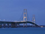
The Straits of Mackinac connects Lake Michigan and Lake Huron, and separates the Lower and Upper Peninsulas of Michigan, in hydrological terms is actually “a narrow point defining two lobes of a single Lake Michigan-Huron”.
|
|
(45º48'50"N 84º45'0"W)
|
|
The French word “detroit”, meaning strait, is the name given to a portion of the water connection between Lake Huron and Lake Erie, and to the city that is on the Michigan side of the U.S.-Canada border. It is better known as the Detroit River.
|
|
|
|
|
|
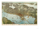
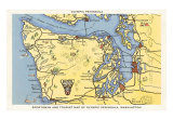
The city of Seattle, Washington is built on an isthmus between Puget Sound and Lake Washington.
|
|
|
|
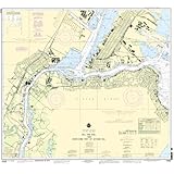
Kill Van Kull, a tidal strait between Staten Island, New York and Bayonne, New Jersey, connects Newark Bay and Upper New York Bay.
The name reflects the early Dutch settlement of New York: Kill comes from the Middle Dutch word kille, meaning riverbed, water channel, or stream; Kul is from col meaning a passage to the interior.
|
|
|
|
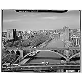
The Harlem ”River” is another tidal strait in the Hudson River estuary, New York City; it has no source or mouth. It flows between the Hudson and East Rivers, separating the boroughs of Manhattan and the Bronx. |
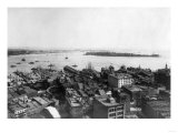
| The Narrows is also a tidal strait and is the principal channel for the Hudson River to empty into the Atlantic Ocean. Known as the Verrazano Narrows it forms the boundary between the boroughs of Staten Island and Brooklyn in New York City, and connects the Upper New York Bay and Lower New York Bay. |
|
|
|
|
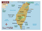
The Taiwan, or Formosa, Strait in the South China Sea, separates the island of Taiwan from the Asian mainland. At its narrowest point it is 81 miles wide.
• more China posters
|
|
|
|
|
|
|
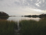
Long Island Sound is a long, narrow, and shallow estuary (a place where fresh and salt water mix) of the Atlantic Ocean, located between Connecticut to the north and Long Island, New York to the south, in the United States.
Long Island Sound is home to more than 1,200 species of invertebrates, 170 species of fish, and dozens of species of migratory birds live at least part of the year. More than 21 million people live within 50 miles of the sound.
|
|
|
|
|
|
|
|
|
|
|
previous page | top
|
|
I have searched the web for visual, text, and manipulative curriculum support materials - teaching posters, art prints, maps, charts, calendars, books and educational toys featuring famous people, places and events - to help teachers optimize their valuable time and budget.
Browsing the subject areas at NetPosterWorks.com is a learning experience where educators can plan context rich environments while comparing prices, special discounts, framing options and shipping from educational resources.
Thank you for starting your search for inspirational, motivational, and educational posters and learning materials at NetPosterWorks.com. If you need help please contact us.
|
|
|