|
|
|
|
|
|
|
|
|
|
|
|
|
|
|
|
|
|
|
|
|
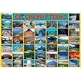
GEOGRAPHY TEACHING RESOURCES
|
|
|
|
|
|
|
|
|
|
|
|
|
|
|
|
|
|
|
|
|
|
|
|
|
|
|
|
|
|
|
 |
|
|
|
World Geography Posters, Charts, Photographs & Maps Index
for social studies educators and home schoolers, decor for office and home.
|
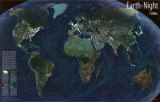
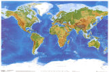
WORLD GEOGRAPHY | geographers < landforms < Earth from Space < social studies
|
|
Geography is the scientific study of the Earth's physical features, resources, climate, and human interventions. The word geography derives from the Greek words “geo” (Earth) and “graphy” (“to write,” as in “to describe”).
Knowing that three fourths of the Earth's surface is covered by oceans and half the land area is inhospitable due to mountains or deserts, underscores the importance of georgraphic study for understanding how “place” affects our world outlook and actions.
Geography study is an essential part of conscious ‘in-forming’ of individuals about place and time in relation to one another for the creative process and survival of humankind on Earth.
The Creative Process Geography pages juxtapose allegorical and scientific images and illustrations to prompt learning across disciplines and provide access to supplemental and enrichment materials for the geography, history, the Earth sciences and social studies classrooms.
|
|
|
 |
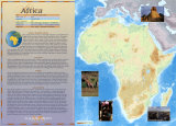
Africa Posters
Africa is the second largest continent, and the third most populous, on Earth.
|
|
 |
Antarctica Posters
Antarctica is the name for the landmass surrounding the Earth's South Pole. The name indicates the opposite of arctic, or the North Pole.
|
|
 |
Asia Posters
Asia, the largest continent on Earth, is defined by subtracting Europe and Africa from the great land mass of Africa-Eurasia.
|
|
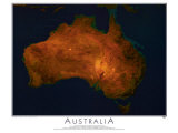 |
Australia Posters
Australia, both Earth's smallest continent and the 6th largest nation, is in the Southern Hemisphere.
|
|
 |
Europe Posters
Europe, usually considered the Earth's second smallest continent, is physically (geology and geography) a peninsula forming the western most part of Eurasia.
|
|
 |
The Living Americas -
The Americas, often referred to as the "New World", are the continents occupying the western hemisphere of Earth.
|
|
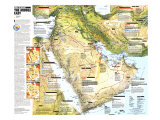 |
Middle East Posters
The term Middle East defines a cultural area and is a subregion of Africa-Eurasia comprising the lands around the southern and eastern parts of the Mediterranean Sea and extending from the eastern Mediterranean Sea to the Persian Gulf.
|
|
|
|
World Cities Posters
A city is defined as “an urban area of high population density with some degree of self-government”, differentiated from towns, villages, and hamlets by size, importance or legal status.
|
|
|
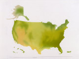
Map United States
National Park System
|
National Parks
Reserves of land and/or sea set aside for “public use, resort, and recreation”.
|
|
|
|
|
|
|
|
|
|
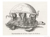
According to Hindu mythology Vishnu, in his second incarnation, becomes a tortoise supporting Mount Mandara so the gods can churn the cosmic ocean for the drink of immortality.
• see Wikipedia for “Turtles all the way down”.
|
|
|
|
|
|
previous page | top | WORLD GEOGRAPHY | geographers
|
|
I have searched the web for visual, text, and manipulative curriculum support materials - teaching posters, art prints, maps, charts, calendars, books and educational toys featuring famous people, places and events - to help teachers optimize their valuable time and budget.
Browsing the subject areas at NetPosterWorks.com is a learning experience where educators can plan context rich environments while comparing prices, special discounts, framing options and shipping from educational resources.
Thank you for starting your search for inspirational, motivational, and educational posters and learning materials at NetPosterWorks.com. If you need help please contact us.
|
|
|