|
|
|
|
|
|
|
|
|
|
|
|
|
|
|
|
|
BOOKS ABOUT
CENTRAL AMERICA
|
|
|
|
|
|
|
|
|
|
|
|
|
|
|
|
|
|
|
|
|
|
|
|
|
|
|
|
|
|
|
|
|
|
|
|
|
 |
|
|
|
|
Central America Posters, Art Prints, Charts, & Maps Index
|
geography > North America > CENTRAL AMERICA < Hispanics and Latinos < Native Americans < social studies
|
|

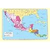
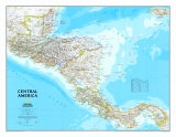
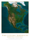
Central America Map Poster,
Political 1986
|
|
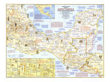
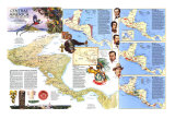
Central America is generally understood to be a geographic region between the Pacific Ocean and the Caribbean Sea consisting of an isthmus connecting the larger land masses of North and South America; and a political-economic region consisting of the countries of Belize, Guatemala, El Salvador, Honduras, Nicaragua, Costa Rica, and Panama.
In the early 19th century the present day El Salvador, Guatemala, Honduras, Nicaragua, and Costa Rica (and a part of the Mexican state of Chiapas) formed The United States of Central America. In 1991 the seven nations of Central America, plus the Caribbean island nation of the Domincan Republic formed SICA (Sistema para la Integracion Centroamericana).
Central America is a geologically active region with earthquakes and volcanic eruptions due to the Pacific Plate steadily subducting under the relatively stable Caribbean Plate. The entire isthmus is a “biodiversity hotspot” with multiplicity of biological resources and indigenous cultures.
|
|
|
|
|
|
|
|
|
|
|
|
|
|
|
|
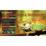
Biosphere: Adaptations & Biodiversity
Poster Text: An adaption is a change in the structure or function of an organism which allows it to thrive within its environment. It may take physical adaptation such as the size or shape of the organism or it way in whch its body works. It may also be a change in an animals behavior. Adaptation is produced through the process of natural selection. As the environment changes, organisms that cannot adapt eventually die. Individuals with the ability to adapt produce more successful offspring. These offspring may carry the adaption forward until the whole species contains organisms which are adapted to the new environment.
An organism's environment consists of many important element whcih can influence adaption. Whether the climate is hot, cold, dry or wet will have an effect on all creatures that live in that environment. The presence of predators will also have an effect. Prey animals must learn to defend themselves or become adept at escaping predators.
• more Eco-sphere posters
• Biodiversity in Belize
|
|
|
previous page | top
|
|
I have searched the web for visual, text, and manipulative curriculum support materials - teaching posters, art prints, maps, charts, calendars, books and educational toys featuring famous people, places and events - to help teachers optimize their valuable time and budget.
Browsing the subject areas at NetPosterWorks.com is a learning experience where educators can plan context rich environments while comparing prices, special discounts, framing options and shipping from educational resources.
Thank you for starting your search for inspirational, motivational, and educational posters and learning materials at NetPosterWorks.com. If you need help please contact us.
|
|
|