|
|
|
|
|
|
|
|
|
|
|
|
BOOKS ABOUT MAPS & MAPMAKING
|
|
|
|
|
|
|
|
|
|
|
|
|
|
|
|
|
|
|
|
|
|
|
|
|
|
|
|
|
|
|
 |
|
|
|
Maps Educational Posters & Charts, pg 1 of 5
for the social studies and science classroom, home schoolers, theme decor for home and office.
|
social studies > MAPS & CHARTS pg 1 | 2 | 3 | 4 | US maps | NG Maps | ocean maps < geography
|
|
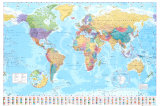
Maps are 2-dimensional representations of 3-dimensional space. The art and science of map making is called cartography (Greek chartis = map, graphein = write).
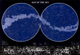
Posters include ‘The Globe’, Oceans and Seas, the Ocean Floor, World Maps, Universe Map, Sky Map, European Political map, Underground Railroad map, maps of the internet, satellite maps and a template for creating a huge USA mural map.
|
|
|
|
|
|
Ancient Civilizations Map and Timeline showing location and time relationships of Mesopotamia, Ancient Egypt, Indus Valley, Huang Ho Valley, Ancient Greece, Ancient Rome, Maya, Inca, Aztec.
• Ancient Civilizations Posters
|
|
|
|
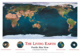
The Living Earth - Pacific Rim View
The Pacific Ring of Fire is the zone of frequent earthquakes and volcanic eruptions partially surrounding the Pacific Basin. This Dynamic Earth, USGS
|
|
|
|
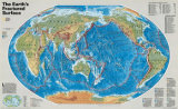
The Earth's Fractured Surface Map
National Geographic map shows the tectonic plates in their current configuration, and describes how landforms are reshaped over millions of years. It is printed at a scale of 1 inch to every 757 miles.
|
|
|
|
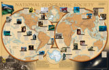
World of National Geographic Map
Learn about the events and cutting-edge research that National Geographic supports around the globe with this fascinating map. It is printed at a scale of 1 inch to every 749 miles.
|
|
|
|
|
|
|
|
|
|
|
|
|
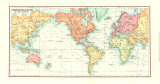
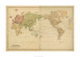
The World on Mercator's Projection
Gerardus Mercator created a map that could represent line of true course, making the Mercator projection very useful to explorers and navigators.
|
|
|
|
Our Spaceship Earth
Fuller Projection from Space -
(“Dymaxion” map by Buckminster Fuller, projection onto a polyhedron net which can be unfolded in many ways as a 2-dimensional map retaining most of the relative proportions.)
|
|
|
|
|
|
Maps 1 | 2 | 3 | 4 | US maps | Lewis & Clark | ocean maps | previous page | top
|
|
I have searched the web for visual, text, and manipulative curriculum support materials - teaching posters, art prints, maps, charts, calendars, books and educational toys featuring famous people, places and events - to help teachers optimize their valuable time and budget.
Browsing the subject areas at NetPosterWorks.com is a learning experience where educators can plan context rich environments while comparing prices, special discounts, framing options and shipping from educational resources.
Thank you for starting your search for inspirational, motivational, and educational posters and learning materials at NetPosterWorks.com. If you need help please contact us.
|
|
|