|
|
Middle East Geography Posters, Prints, Charts, Photographs & Maps Index
for the social studies and arts classrooms, and home schoolers.
|
geography > MIDDLE EAST < social studies
|
The term Middle East defines a cultural area, so does not have precise borders. It is a subregion of Africa-Eurasia comprising the lands around the southern and eastern parts of the Mediterranean Sea and extending from the eastern Mediterranean Sea to the Persian Gulf (Indian Ocean). North African nations are frequently called North Africa to differentiate from the Middle Eastern Asia - Iran to Egypt - by international media. The three major cultures of the Middle East are Persian, Arabic and Turkish.
|
|
|
|
|
|
|
|
|
|
|
|
|
|
|
|
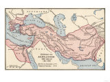
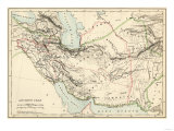
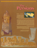
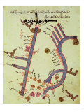
The Persians
(550 B.C. — 331 B.C.)
At its peak, the Persian Empire was one of the largest in history. The Persians controlled an area roughly the size of the present day United States. The empire they created lasted a little more than 200 years. But in that short time, they made many important contributions to world civilization. The ruins of some of their great cities can still be seen today in the nation of Iran, whch was once called "Persia."... <more>
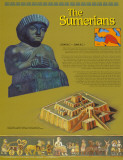
Artwork in poster depicts a Sumerian ziggurat, a decorative panel from a wooden box found at Ur, and a statue of the Sumerian king Gudea.
|
|
|
|
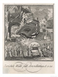
Ancient Sumerians —
(3500 B.C. — 2000 B.C.)
Most experts agree that the Sumerians built the world's first civilization. The Sumerians lived in a region of the world known as Mesopotamia, or the Fertile Cresent. This area runs along two rivers, called the Tigris and the Euphrates, and along the eastern coast of the Mediterranean Sea. it is now a part of the nations of Iraq, Syria, Lebanon, Jordan, and Israel. ... <more>
Artwork in poster depicts a Sumerian ziggurat, a decorative panel from a wooden box found at Ur, and a statue of the Sumerian king Gudea.
|
|
|
|
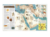
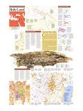
The Tigres (eastern) and the Euphrates (western) are the two rivers that define the area of Mesopotamia, the “cradle of civilization”. The Greeks called the area Mesopotamia, meso+potamos, literally “between the rivers”. (Do you see hippo+potamus = river horse?).
The Tigres and Euphrates Rivers are part of the “Fertile Crescent”, an historic Middle East region that corresponds to present-day Egypt, Israel, West Bank, Gaza strip, and Lebanon and parts of Jordan, Syria, Iraq, south-eastern Turkey and south-western Iran.
Both the Tigris and Euphrates rise in eastern Turkey, flowing nearly parallel to one another before merging shortly before flowing into the Persian Gulf.
|
|
|
|
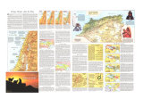
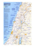
Jericho, located on the West Bank near the Dead Sea, is one of the oldest continuosusly-inhabited cities in the world, dating back to 9000 BC.
The name Jericho may be derived from the Hebrew word meaning “moon” as the city was an early center of worship for lunar deities.
The Biblical account of the destruction of Jericho is found in the Book of Joshua.
• Middle East posters
|
|
|
|
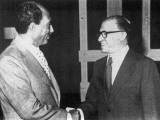
Anwar Sadat & Menachem Begin Poster
Poster Text: Anwar Sadat and Menachem Begin shared the 1978 Nobel Peace Prize for their efforts to solve one of the oldest and most difficult problems in the world: the conflict between Arabs and Jews in the Middle East. Tensions between these groups grew worse when at separate state for the Jewish people, the nation of Israel, was created in 1948 from the Arab state of Palestine. The Arabs immediately attacked the new nation of Israel. And Israel and the Arab nations, including Egypt, became bitter enemies. In the years that followed, Israelis and Arabs fought several brief but violent wars. The Arab countries were determined to destroy Israel, and the Israelis fought back aggressively.
Anwar Sadat was on Egyptian military office who took part in efforts to overthrow hsi nations government in the 1940s. Later he became Egypt's Vice President under Egyptian President Gamal Abdel Nasser. When Mr. Nasser died in 1970, Mr. Sadat took over. He called for Israel to return land it had taken from Egypt in a 1967 war. But in 1977, President Sadat began discussions with Israeli leader Menachem Begin about ways to end the conflict between their two nations.
Mr. Begin was one of many people who fought during the 1930s and 1940s for the creation of Israel. After Israel was formed, Mr. Begin served in the Israeli Parliament which is called the Knesset. He became the Prime Minister of Israel in 1977.
Together with U.S. President Jimmy Carter, Mr. Sadat and Mr. Begin met for peace talks. The talks resulted in an agreement that called for Israel to withdraw from the Sinai Peninsula and the Gaza Strip. It als called for a formal peace treaty between Israel and Egypt. And it said Israel must take steps to give Palestinian Arabs in the West region their own government. The agreement, which became known as the Camp David Accords, won Mr. Sadat and Mr. Begin the Nobel Peace Prize.
Sadly President Sadat was killed in 1981 by Arabs opposed to peace with Israel. And after Mr. Begin resigned as Prime Minister in 1983, he took little part in Israeli politics. He died in 1992.
Even though some parts of the Egyptian-Israeli peace treaty have not been fulfilled, the agreement was an important first step toward peace in the Middle East.
• more Nobel Peace Prize Winner posters
• Anwar Sadat & Menachem Begin at Amazon.com
|
|
|
|

America: A Nation of Immigrants: South Asia and the Middle East poster
poster series
no longer available
|
South Asia and the Middle East-
The silk industry around Mount Lebanon in Syria prospered for many years. This region, which is now Lebanon, is rugged and mountainous. Many Lebanese people earned a living by cultivation silkworms and weaving the delicate threads into cloth. The Lebanese were also potters, craftsmen, and farmers. Then in 1869, the Suez Canal in Egypt opened, proving a shorter route between Europe and the Far East. Europeans started to buy their silk from China instead of Lebanon. The loss of the silk trade was only one problem the Lebanonese faced at that time. By the last half of the 19th century, the population of Syria had greatly increased, and the amount of arable land had decreased. Lebanese people looked to the United States as a land of opportunities. Lebanese families often combined their resources to send promising young people to America. These immigrants, in turn, sent part of their earnings back to their families. Lebanese immigrants did not want to work in factories or mines. So many took up a completely new profession. Both men and women became peddlars. For a small investment or for credit, peddlars filled backpacks and suitcases with small items, such as laces, tools, and kitchenwares. Each day, they trampled many miles carrying their heavy packs. They sold their products to housewives and people who worked all day in factories and could not always get to stores. Lebanese peddlers met many other Americans every day. They quickly learned English and American culture.
Some immigrants from Iraq, Palestine, and other countries did find jobs on farms and in factories here. A large number settled in Detroit to work in the automobile industry. In the 1960s and '70s, Iran experienced a "brain drain" when thousands of Iranian students and professionals took up permanent residence in the United States. Iranians immigrated for better jobs and education, and to escape political turmoil. Most of the immigrants from Turkey were Armenians who came to America to escape horrible conditions in their native land. Some were professionals or merchants, but in the United States, most had to start as unskilled laborers. Later, they opened shops and restaurants.
In the early 1900s, a drought in the Punjab region in India hurt many farm families. Some Indian families then sent their sons to America to earn mony to send back home. In America, some of these East Indian immigrants became successful farmers and business owners. When U.S. immigration restrictions were relaxed in 1965, many highly trained Indians and their families came to America. The new law also opened the door to immigrants from Pakistan, Bangladesh, and Sri Lanka. In America, some East Indians have worked hard to retain their culture. Sikh Indians still wear distinctive turbans. Young East Indian girls attend schools where they learn traditional dances. And East Indians philosophy, music – which features the sitar and the tabla – and religions principles of nonviolence have made their way into American culture.
|
|
|
|
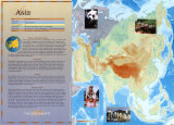
Continent of Asia
Poster Text:
PHYSICAL FEATURES/CLIMATE
Asia is a huge contient with an incredible variety of climates and land features, ranging from tropical jungles to the frozen Arctic. ... Southwest Asia is mainly desert and some mountains.
RESOURCES: ... Minerals are also an important Asian resource. Southwest Asia provide a large portion of the world's oil, and Southeast Asia produces much of the world's tin. ...
WILDLIFE: The wildlife in Asia is as diverse as its many climates. ... to palm trees in the southwest to poppies and bamboo in the southeast.
HISTORY/PEOPLE: Civilization began in Asia more than 5,000 years ago. Ancient Asian civilizations made huge advances to science, technology, and culture. Asia is home to the world's first cities, and the first systems of law, writing, and literature were invented there. The world's major religions – Judaism, Christianity, Islam, Hindusim, and Buddhism, among others – started in Asia. The people of Asia differ greatly in their cultures, languages, religions beliefs, and ways of life. They can be classified into three main groups. One group includes Arabs, Jews, and most of the peple west of India. Another group includes the people of Pakistan and India. A third group includes the people of China, Japan, and most of the people of Southeast Asia. More Asians practice Hinduism than any other religions. The second most popular religion is Islam. Buddhism is prevalent in Sutheast Asia. Arabic, Hebrew, Russian, Chinese, Japanese and the dialects of India and Southeast Asia are among the many languages spoken by the people of Asia.
• more Asia posters
• more continents posters
|
|
|
|
Plate Tectonics / Plate Boundaries and Movement
The theory of plate tectonics describes the Earth's crust (the lithosphere) as segmented into several plates, which float and move on a soft layer (the asthenosphere) ... illustration of the the Arabian Plate and the African Plate pulling away from one another.
• more Earth Processes posters
|
|
|
|
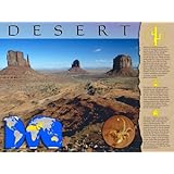
Desert Biome
Poster Text: Deserts are harsh environemnts found all around the world, covering about one-fifth of the planet. Characterized by low rainfall, deserts receive less than 25 centimeters of rain per year. While most are swelteringly hot, such as the Australian Desert, a few, like the Gobi Desert in Asia can get very cold. Desert temperatures might also drop at night, and can plunge below freezing during the winter season. Despite the lack of water and other extreme conditions, most deserts are home to many species of plants and animals.
Life native to the desert is highly specialized and well-adapted to the extreme climate. Sagebrush, short grasses, creosote bushes and cacti are just a few of the plants found there. Desert plants have root and water storage systems ideal for minimizing moisture loss. Within hours of rainfall, desert plants bloom, reproduce, and store water needed for the coming drought.
The desert is home to many reptiles, insects, birds and some small mammals, such as the kangaroo mice in North America. The animals surviving in the desert have evolved perfectly to suit the climate. Most desert animals are nocturnal, sheltering themselves from the sun during the day, either in shade or burrows. A unique physical adaptation is the storage of fat in humps or tails, rather than throughout the body, as fat causes heat to intensify. The absence of sweat glands, and the concentration of urine are other physical adaptations.
• Biomes poster series
|
|
previous page | top
|
|
I have searched the web for visual, text, and manipulative curriculum support materials - teaching posters, art prints, maps, charts, calendars, books and educational toys featuring famous people, places and events - to help teachers optimize their valuable time and budget.
Browsing the subject areas at NetPosterWorks.com is a learning experience where educators can plan context rich environments while comparing prices, special discounts, framing options and shipping from educational resources.
Thank you for starting your search for inspirational, motivational, and educational posters and learning materials at NetPosterWorks.com. If you need help please contact us.
|
|
|