|
|
Bays, Gulfs and Headlands of the World Posters, Prints, Charts
for oceanography and marine environment, ecology, and geography educators & classrooms.
|
science > aquatic/marine > water > BAYS, GULFS & HEADLANDS < oceans < landforms < geography < social studies
|
A bay is a body of water that is partly enclosed by land and is usually smaller than a gulf. Bays are formed when the coastline has varying degrees of resistance to the eroding effect of water.
The terms gulf and sea refer to very large bays formed by tectonic movement of the Earth's crust.
A bight is a bend or curve where land and water meet, a large bay with a very gradual curve. The Bight of Benin and the Bight of Bonny are features western African coast, the Great Australian Bight is the southern coast of Australia, the Mid-Atlantic Bight is the slight curve in the east coast of North America from Massachusetts to North Carolina, and the coast of Southern California is a bight
A sound is an ocean or sea inlet that is larger than a bay, deeper than a bight, and /or wider than a fjord. A sound can also be a channel between two bodies of land, i.e. Long Island Sound, Puget Sound, and also the definition of a strait.
A headland is land surrounded by water on three sides: a large headland is a peninsula; promontories are long, narrow and high headlands; a cape is a headland that signicantly affects ocean currents.
FYI - To describe the features of a gulf or bay will envolved describing the headland that borders the water. The water and land share the “same edge”.
|
|
|
|
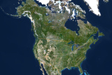
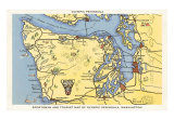
Hudson, James and Baffin Bay
• Baffin Bay - between Atlantic & Arctic Ocean, usually filled with ice, Greenland to the east;
• Hudson Bay - NE Canada,
• James Bay is a southern offshoot;
• the Saint Lawrence River drains the Great Lakes into the Atlantic Ocean at the Gulf of Saint Lawrence.
On the west coast of North America is the Gulf of Alaska, and the Alaska and Kenai Peninsula.
|
|
|
|
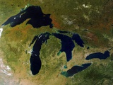
The Great Lakes of North America show examples of bays and and peninsulas - in fact the state of Michigan is two non-contiguous peninsulas referred to as the upper and lower, and the one of the state mottos is, “If you seek a pleasant peninsula, look about you.” The upper and lower peninsulas of Michigan are connected by the five mile long Straits of Mackinaw Bridge.
The five lakes are Superior, Michigan, Huron, Erie, and Ontario. Lake St. Clair is part of the lake system.
Freshwater from Lake Superior passes through the St. Marys River into Lake Huron (boat traffic bypasses the rapids with the five locks of the Soo Canals), Lake Huron to Lake Erie via the St. Clair River, Lake St. Clair, and the Detroit River, then the water flows from Erie to Ontario on the Welland Canal, who eight locks bypassing the Niagara escarpment, from there the St. Lawrence River leads out to sea.
Lake Michigan has Green Bay on the Wisconsin side and Grand Traverse Bay on the Michigan side. Saginaw Bay on the Michigan side (the “thumb”), and Georgian Bay, on the Canadian Ontario side, are the largest bays in Lake Huron.
• lake posters
|
|
|
|
The Chesapeake Bay, the ria or drowned valley of the Susquehanna River, is the largest estuary in the United States. The bay, lying off the Atlantic Ocean, is surrounded by the Delmarva Peninsula to east of the bay and the mainland to the west.
The peninsula's name is the portmanteau (a constructed word that combines both sounds and meanings) formed from the names of the states: Delaware (located entirely on the peninsula), Maryland, and Virginia.
More than 150 rivers and streams drain the Chesapeake Bay watershed which covers the District of Columbia and parts of six states.
|
|
|
|
The Gulf of Mexico, at approximately 810 nautical miles wide, is the 9th largest body of water on Earth. The Gulf is an extension of the Atlantic Ocean bounded by the North American Continent from the peninsulas of Florida, on the east, and the Yucatan (Maya posters), on the west. The gulf is connected to the Atlantic through the narrow strait between Florida and the island of Cuba, and to the Caribbean Sea through the Yucatan Channel.
Notable cities on the Gulf include Tallahassee, FL; Mobile, AL; New Orleans, LA; Houston and Corpus Christi, TX; Coatzacoalocos and Cancun, Mexico; and Havana, Cuba.
The southern coast of the Gulf of Mexico is called the Bay of Campeche, which is a bight.
FYI - The Gulf of Mexico and the Caribbean Sea combined are called the American Mediterranean Sea.
DYI? Christopher Columbus never entered the Gulf of Mexico, he salied into the Caribbean. The first European explorer into the Gulf was Amerigo Vespucci in 1497.
|
|
|
|
Bay of Bengal, the largest bay in the world, forms the northeastern part of the Indian Ocean. The bay, resembling a triangle pointing north, is bordered by Bangladesh, India, and Sri Lanka to the west and Burma (Myanmar) and the Andaman and Nicobar Islands to the east.
The word Bengal comes from the Sanskrit Banga or Vanga which refers to the delta waters of the river Ganges.
|
|
|
|
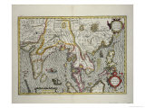
Malay Peninsula extends from the Indochina Peninsula of Southeast Asia with the Bay of Bengal is on the west and the Gulf of Thailand on the east.
The area contains the southernmost tip of Burma, Peninsular Malaysia, Singapore, and Southern Thailand.
|
|
|
|
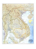
The Gulf of Tonkin, an arm of the North China Sea, borders the east coast of the Indochina Peninsula of Southeast Asia.
The Gulf of Tonkin was the site of open conflict between the United States and North Vietnam which resulted in the “‘Gulf of Tonkin Resolution’ (August 1962), which granted President Lyndon B. Johnson the authority to assist any Southeast Asian country whose government was considered to be jeopardized by ‘communist aggression’”, and on to the Vietnam War.
The Gulf of Thailand (Siam), a shallow arm of the South China Sea, lies to the west of the Indochina Peninsula.
|
|
|
|
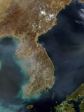
The Korean Peninsula extends southwards from continental Asia into the Pacific Ocean and is surrounded by the Sea of Japan (East Sea) to the south, and the Yellow Sea to the west, the Korea Strait connecting the first two bodies of water.
The largest cities on the Korean Peninsula are Seoul, South Korea and Pyongyang, North Korea.
|
|
|
|
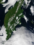
Kamchatka Peninsula is in the Russian Far East between the Pacific Ocean and the Sea of Okhotsk. The peninsula is made up of many sizable volcanoes.
|
|
|
|
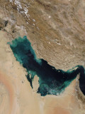
The Persian Gulf in Southwest Asia is an extension of the Indian Ocean through the very narrow Strait of Hormuz to the Gulf of Oman to the east. Its western end is marked by the major river delta of the Shatt al-Arab, which carries the waters of the Euphrates and the Tigris, and the Arabian Peninsula.
The Persian Gulf takes its name from Persia, which is known as Iran today.
The Persian Gulf was the site of the 1980-1988 Iran-Iraq War and the 1991 “Gulf War” with the invasion of Kuwait by Iraq.
FYI - The Persian Gulf and its coastal areas are the world's largest single source of crude oil and related industries dominate the region.
|
|
|
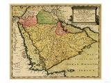
Arabian Peninsula is the world's largest peninsula, and is considered a subcontinent. It is surrounded by the Red Sea to the west, the Gulf of Aqaba to the northwest, to the northeast by the Persian Gulf and the Gulf of Oman, and the Arabian Sea (part of the Indian Ocean) to the southeast. The Gulf of Aden connects the Red Sea to the Arabian Sea as part of the southern coast of Arabian Peninsula.
|
|
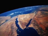
The Egyptian Sinai Peninsula splits the northern Red Sea into two arms - the Gulf of Suez on the left and the Gulf of Aqaba on the right. The area is between the continents of Africa on the west and Asia on the east. At the northern end of Gulf of Suez is the Isthmus of Suez which has been cut by the Suez Canal, an artificial sea-level waterway, connecting the Mediterranean and the Red Seas, and eliminating the need to sail around the Cape of Good Hope.
|
|
|
|
|
|
|
|
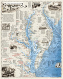
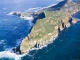
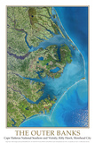
Cape Hatteras, the southeastern point of long shoals or sandbars (promontory) on Hatteras Island, is part of the Outer Banks, a 200-mile (320-km) long string of narrow barrier islands off the coast of North Carolina.
Roanoke Island, which was the site of the English Roanoke Colony that disappeared c. 1587, and Kill Devil Hills near Kitty Hawk where the Wright Brothers were the first to fly a powered, heavier than air vehicle in 1903, are part of the Outer Banks. Albemarle-Pamlico Sounds are a part of the interconnected network of lagoon estuaries.
The Outer Banks, known as the “Graveyard of the Atlantic” were also hiding places for pirates like Edward Teach, aka “Blackbeard.”
• Shipwrecks of the Outerbanks Map
|
|
|
|
|
|
|
|
|
|
|
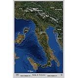
Three Peninsulas of Southern Europe
• Italian Peninsula, also known as the Apennine Peninsula,
• Iberian Peninsula of Spain, and Portugal (northern coast Bay of Biscay), and
• Balkan Peninsula with Albania, Bosnia & Herzegovina, Bulgaria, Greece, Kosovo, Macedonia and Montenegro.
|
|
|
|
|
|
|
|
|
|
|
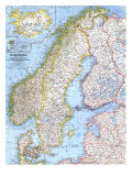
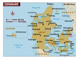
The Bay and Gulf of Bothnia are arms of the Baltic Sea between the east coast of Sweden and the west coast of Finland; the Gulf of Finland extends from the Baltic between Finland and Estonia. Denmark consists of a large peninsula and many islands often referred to as the Danish Archipelago.
• Scandinavia posters
|
|
|
|
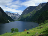
Fjords are a long, narrow inlets with steep sides or cliffs, carved by glacial activity. The word fjord is from the Norwegian. Sognefjord is one of the longest and deepest fjords in the world.
In Scotland, similar landforms are called firths.
There are long deep freshwater lakes that are formed by glacial activity
|
|
|
|
Island, Peninsula, and Cape
Poster text:
Cape: A point or head of land, projecting beyond the adjacent coast into a body of water.
Island: Any piece of land, smaller than a continent and larger than a rock, which is completely surround by water. Very small islands are called islets. Groups of related islands are called archipelagos.
Atoll: A ring of coral islands or reefs usually surrounding an interior body of water called a lagoon. Atolls often mark the location of submerged mountain ranges or extinct volcanic islands.
Peninsula: A narrow extension of land surrounded on three sides by water, but connected to a larger land mass. Usually more extensive than a cape.
• Landform poster series -
|
|
|
previous page | top
|
|
I have searched the web for visual, text, and manipulative curriculum support materials - teaching posters, art prints, maps, charts, calendars, books and educational toys featuring famous people, places and events - to help teachers optimize their valuable time and budget.
Browsing the subject areas at NetPosterWorks.com is a learning experience where educators can plan context rich environments while comparing prices, special discounts, framing options and shipping from educational resources.
Thank you for starting your search for inspirational, motivational, and educational posters and learning materials at NetPosterWorks.com. If you need help please contact us.
|
|
|
|