GEOGRAPHY INDEX
................

Africa
Antarctica
Asia
Australia
Caribbean/West Indies
Central America
Cities
Europe
Explorers
Geographers
Landforms -
bays, gulfs, headlands
biomes
continents
deserts
Earth from Space
islands
isthmus & straits
lakes
mesa, plateau, butte
monolith
mountains
oceans & seas
river & stream
volcanoes
wetlands
Maps
Middle East
National Parks
North America
South America


WETLANDS BOOKS

Wetlands
Wetlands


A Wetland Habitat
A Wetland Habitat


Explore Aquatic Ecosystems - Wetlands (Set of 5)
Explore Aquatic Ecosystems -
Wetlands (Set of 5)


National Wetlands Newsletter


World Wetlands Day
February 2


FREE
Wetlands Education Posters
online pdfs from USGS


America's Wetlands:
Our Vital Link Between
Land and Water: EPA


SCIENCE KITS

Landform Discovery Pack


WATER CALENDARS

Water Calendars
Water Calendars


Teacher's Best - The Creative Process


Wetlands of the World, “A...-”
for geography and social studies classrooms, home schools.


world geography > landforms > wetlands | A | b | c | d | e-f | g-l | m-n | o-p | q-s | t-z < social studies


Albemarle-Pamlico Sounds
Atchafalaya

Assateague

Azraq


A Windsurfer Skims the Silver Surface of Pamlico Sound at Twilight, Photographic Print

(36º3'55"N 76º3'52"W)

Albemarle - Pamlico Sounds, in North Carolina, are part of a large, interconnected network of lagoon estuaries. The Outer Banks islands form the protective barrier from the Atlantic Ocean.


Atchafalaya River Delta, Only Louisiana Area Where Land is Increasing, Photographic Print

(29º26'30"N 91º25'0"W)

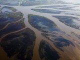
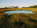
Atchafalaya Basin, in Louisiana, is the largest swamp in the United States, is a combination bayous, bald cypress swamps, marshes and brackish estuarine conditions of a river delta where the Atchafalaya River meets the Gulf of Mexico.


Salt Marsh, Assateague Island, Virginia, Photographic Print

(37º58'35"N 75º18'17"W)

Assateague Island, a 37 long barrier island off the eastern coast of Maryland and Virginia, has numerous marshes, bays and coves. It is best known for its herds of feral ponies that were the subject of Marguerite Henry's story Misty of Chicoteague.


Raised Walkway Through Marshlands, Azraq Wetlands Reserve, Amman, Jordan, Photographic Print
Raised Walkway Through Marshlands, Azraq Wetlands Reserve, Amman, Jordan,
Photographic Print

(31º50'0"N 36º49'0"E)

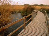
The Azraq Wetland Reserve is located in the eastern desert of Jordan at the site of an ancient oasis, the only permanent source of fresh water in approximately 12,000 square kilometres of desert.

The natural springs dried up in 1992, the aquifer drained by urban growth. 10% of wetlands are now kept moist with artifical springs, competing for water in a water short nation.


previous page | top | next
wetlands | A | b | c | d | e-f | g-l | m-n | o-p | q-s | t-z


I have searched the web for visual, text, and manipulative curriculum support materials - teaching posters, art prints, maps, charts, calendars, books and educational toys featuring famous people, places and events - to help teachers optimize their valuable time and budget.

Browsing the subject areas at NetPosterWorks.com is a learning experience where educators can plan context rich environments while comparing prices, special discounts, framing options and shipping from educational resources.

Thank you for starting your search for inspirational, motivational, and educational posters and learning materials at NetPosterWorks.com. If you need help please contact us.


NetPosterWorks.com ©2007-2015 The Creative Process, LLC All Rights Reserved.

NetPosterWorks.com ©2007-2015 The Creative Process, LLC All Rights Reserved.

last updated 12/27/13