|
|
|
|
|
|
|
|
|
|
|
|
|
|
|
|
| BOOKS ABOUT SOUTH AMERICA |
|
|
|
|
|
|
|
|
|
|
|
|
|
|
|
|
|
|
|
|
|
|
|
|
|
|
|
|
|
|
|
|
|
|
|
|
|
|
|
 |
|
|
|
|
South America Posters, Art Print, Charts, Photographs & Maps
for social studies, history, geography, and language arts educators and home schoolers.
|
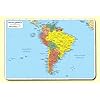
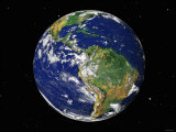
geography > continents > SOUTH AMERICA < social studies
|
|
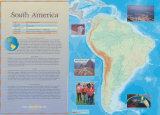
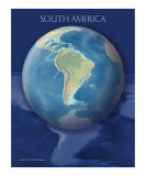
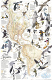
Continent of South America
Poster Text:
PHYSICAL FEATURES/CLIMATE
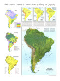
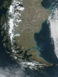
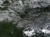
South America is almost completely surrounded by water. Inland, the Amazon River is about 4,000 miles long, making it second only to the Nile in length. The Amazon carries one-fifth of the world's river water. The Amazon River Basin supports the world's largest tropical rain forest. The Andes Mountains, along the west coast, run the entire length of the continent. At 4,500 miles long, the Andes is the world's longest mountain range. Lake Titicaca, located 12,507 feet above sea level on the largest plateau in the Andes, is the world's highest navigable lake. The climate in South America ranges from tropical in the rain forest, to ... and wet in the highlands of the Andes. The Atacama Desert in Chile is one of the driest places on Earth.
RESOURCES: Mining is a large industry in South America, rich deposits of copper, gold, iron ore, bauxite, and petroleum. ...are also inland in South America. Coffee, bananas, and beef are the continent's chief agricultural products. The forest industry produces hardwoods such as mahogany, as well as latex from rubber trees. Clear cutting of the tropical rain forests of South America has created serious environmental problems for the continent, and the world.
WILDLIFE: The greatest variety of animals in South America can be found in the Amazon River Basin. This region supports thousand os species. Manatees, which are large water mammals, live in the Amazon River, as do piranha, a type of carnivorous fish. Many kinds of monkeys can be found in the rain forest. The anaconda, one of the world's largest snakes, is native to the region. So are flamingos, parrots, and toucans. Alpacas, llamas, and guinea pigs were all domesticated in South America. The rain forest also has more plant varieties than anywhere else in the world, including 2,500 types of trees and many exotic orchids.
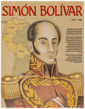
HISTORY/PEOPLE: Many people in South America have mixed Indian, European, and African heritage. The Inca Empire was the first major civilization in South America. the Inca were skilled architects who also built a network of roads in their huge empire. Spanish and Portuguese explorers began arriving on the continent in the late 1400s. Much of South America was claimed by Spanish conquistadors like Francisco Pizarro, who conquered the Inca empire by killing the Inca leader Atahualpa. Africans were brought to the continent as slaves to work on Europeans plantations. Blacks now make up about 12 percent of South America's population. Today, most of the people of South America speak Spanish or Portugese. The majority live in large cities. A few native tribes still live in locations deep in the Amazon Rain Forest.
|
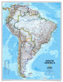
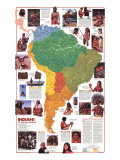
| South America posters, art prints, charts photographs, and maps include Ancient Civilizations: The Inca, satellite image of South America, Rio de Janiero, flags of South America, Patagonia, Machu Picchu, Lake Titicaca, famous explorers, political leaders and writers. |
| The countries of Argentina, Brazil, Paraguay, Uruguay, and Venezuela have formed Mercosur, the Southern Common Market; Bolivia, Chile, Colombia, Ecuador and Peru are in assoicate member status. |
|
|
|
|
|
|
|
|
|
|
|
|
|
|
|
|
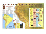
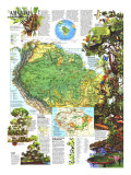
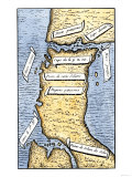
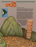
The Incas
(A.D. 1200 — A.D. 1533)
The Inca Indians ruled one of the largest and richest empires in the Western world. The Inca empire at its height stretched for 2,500 miles along the western coast of South America. And it included parts of the present-day countries of Peru, Bolivia, Colombia, Ecuador, Argentina and Chile. The empire was centered around the capital city of Cuzco, located high in the Andes mountains. From there the Inca ruler controlled the lives of his 6 million subjects.
The Inca began their rise to power in the year 1200. At that time, there had already been civilizations in the highlands of Peru for more than 1,000 years. It was from these earlier civilizations that the Incas learned to build fortress walls made from huge blocks of carefully carved stone. The Incas did not use mortar to hold the stones together. Instead, they carved the stones so precisely that they fit perfectly. And many of their walls still stand, despite the many earthquakes that have struck Peru. The Inca were farmers, and they found ways to grow corn and potatoes at elevations of 11,000 feet and higher. They build terraced fields along the steep mountainsides in order to increase the amount of land they could use for growing food. The Inca were also known for their fine cloth and beautiful jewelry. The vast Inca empire was held together by a system of stone highways. Swift runners used these highways to carry messages from the Inca ruler to all parts of the empire. Religion was very important to the Inca. Their most important god was Inti —the sun god. The Inca never developed a system of writing. But special officials kept detailed records with a device called a quipu (key-poo), which was a length of cord with knotted strings of different sizes and colors. Each color or knot stood for a different item.
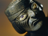
In 1532, the Spanish explorer Francisco Pizarro arrived in South America. Within months, Pizarro and his army had slaughtered most of the Incas and taken the Inca ruler, Atahualpa, prisoner. And even though he paid a huge ransom of gold and silver, Atahaulpa was killed. The Spanish tried to destroy all traces of the Inca empire. But fortunately many Inca objects and ruins have survived the centuries — including the famous city of Machu Picchu, shown here, which attracts thousnds of tourists every year.
Artwork depicts the ruins of Machu Picchu, and a carved stone figure.
• The Ancient Inca (People of the Ancient World)
• more Ancient Civilizations Posters
• more Native Americans Posters -
|
|
|
|
|
|
|
|
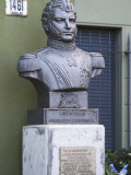
Bernardo O’Higgins
b. 8-20-1778; Chillán, Chile
d. 10-24-1842; Lima, Peru
Bernardo O'Higgins, of Irish and Basque descent, is considered one of Chile's founding fathers.
|
|
|
|
|
|
previous page | top
|
|
I have searched the web for visual, text, and manipulative curriculum support materials - teaching posters, art prints, maps, charts, calendars, books and educational toys featuring famous people, places and events - to help teachers optimize their valuable time and budget.
Browsing the subject areas at NetPosterWorks.com is a learning experience where educators can plan context rich environments while comparing prices, special discounts, framing options and shipping from educational resources.
Thank you for starting your search for inspirational, motivational, and educational posters and learning materials at NetPosterWorks.com. If you need help please contact us.
|
|
|