|
|
|
|
|
|
|
|
|
|
|
|
BOOKS ABOUT EQUADOR & SOUTH AMERICA
|
|
|
|
|
|
|
|
|
|
|
|
|
|
|
|
|
|
|
 |
|
|
|
Ecuador & The Galapagos Posters, Charts, Photographs & Maps
for social studies classrooms, home schoolers, offices.
|
geography > South America > ECUADOR < social studies
|
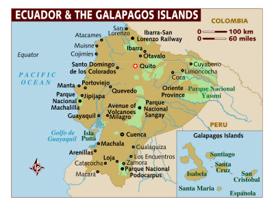
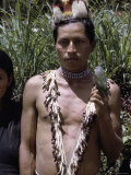
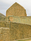
The Republic of Ecuador, which straddles the equator, is located in northwestern South America, bordering the Pacific Ocean on the west (and including the Galapagos Islands), Colombia on the north, Peru on the east and south, and Chile on the south. The west of Ecuador consists of a coastal plain, moving inland to the east are the Andes Mountains and the Amazon rainforest.
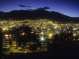
At an altitude of 9,200 feet Ecuador's capital city, Quito, is one of the highest capital cities in the world.
|
|
|
|
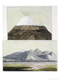
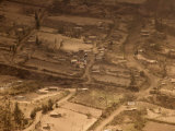
Quito, the capital city of Ecuador, is located on the eastern slopes of Pichincha, an active stratovolcano in the Andes Mountains. In October of 1999, the volcano erupted and covered the city with several inches of ash.
Quito is the second largest city in Ecuador and derives its name from the original Native American inhabitants, the Quitu tribe.
• more world cities
|
|
|
|
Guayaquil, Ecuador's largest city and center of business and manufacturing industries, is located on the western bank of the Guayas River, where it flows into the Pacific Ocean at the Gulf of Guayaquil.
The area was inhabited by Native peoples before the Spanish founded a city in 1538. It has been attacked by English and French pirates, ravaged by yellow fever, and in 1822 José de San Martín and Simón Bolívar held a conference there to plan for South America's independence from Spain.
FYI ~ Guayaquil was founded by Francisco de Orelanna, the first to navigate the length of the Amazon (1541-42).
|
|
|
|
|
|
|
|
|
|
|
|
|
|
|
|
|
|
|
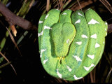
The Emerald Tree Boa, Corallus caninus, is a non-venomous boa species found in the rainforests of South America.
The boa spends the day coiled over a tree branch with its head perched at the center, at night it extends its head downward in order to strike prey that may pass directly below.
The white markings are called “lightning bolts”.
|
|
|
|
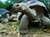
The Galapagos Islands are a Pacific Island archipelago of volcanic islands distributed around the equator about 600 miles west of continental South America. The Galapagos are a province of Ecuador and part of their national park system.
The islands are famed for their vast number of species unique to the location (endemic), and the studies by Charles Darwin during the voyage of the 'Beagle' that contributed to his theory of evolution by natural selection.
The word galapagos from the Spanish “galápago”, “saddle”— after the shells of giant tortoises found only there.
|
|
|
|
|
|
|
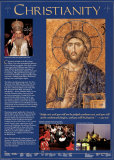
World Religions -
Christianity Wall Poster
“Judge not, and you will not be judged; condemn not and you will not be condemned; forgive, and you will be forgiven.”
Luke 6:37
• more World Religions posters
|
|
|
|
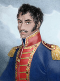
Simón Bolivar
b. 7-24-1783; Caracas, Venezuela
d. 12-17-1830; Santa Marta, Colombia (tuberculosis)
(Text from a poster that is no longer available) Simón Bolivar is often called “the George Washington of South America.” His heroic deeds helped many South American nations win their independence. During his lifetime, he helped millions of Latin Americans realize the dream of freedom. But he died without ever seeing his own fondest dream come true.
Simón Bolivar was born to a wealthy family in Caracas, Venezuela. His parents died when he was just a child, and he inherited a fortune. While on a trip to Europe, he met and married a young Spanish girl. But she died a short time after they returned to Caracas. Returning to Europe, Bolivar vowed that he would one day liberate Venezuela from the Spanish. He fulfilled this promise in 1811 when he captured Caracas and proclaimed Venezuela independent. The Spanish fought back, and soon forced Bolivar to flee to Jamaica and then to Haiti. But Bolivar gathered a force of fighting men and returned to South America. There, his victories over the Spanish led to independence for Bolivia, Colombia, Peru, and Ecuador.
Bolivar's dream was to unite all the countries of South America into one large and powerful nation. But one by one, the countries withdrew from the Colombian Union, as Bolivar called his union. By 1828, Simón Bolivar ruled only what is now Colombia. In 1830 health problems forced him to resign as Colombia's President, and he died in December of that year.
• Hispanic Heritage posters
• Panama
|
|
|
previous page | top
|
|
I have searched the web for visual, text, and manipulative curriculum support materials - teaching posters, art prints, maps, charts, calendars, books and educational toys featuring famous people, places and events - to help teachers optimize their valuable time and budget.
Browsing the subject areas at NetPosterWorks.com is a learning experience where educators can plan context rich environments while comparing prices, special discounts, framing options and shipping from educational resources.
Thank you for starting your search for inspirational, motivational, and educational posters and learning materials at NetPosterWorks.com. If you need help please contact us.
|
|
|