|
|
|
|
|
|
|
|
|
|
|
|
BOOKS ABOUT
NATIVE AMERICANS,
FIRST NATIONS
|
|
|
|
|
|
|
|
|
|
|
|
|
|
|
|
|
|
|
|
|
|
|
|
|
 |
|
|
|
|
|
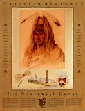
Native Americans Educational Posters, Prints & Charts
for the social studies classroom and home schoolers.
|
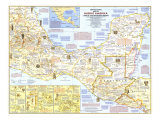
social studies > anthropology > NATIVE AMERICANS POSTERS < List Notable Native Americans < geography/North America < maps
|
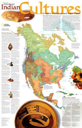
The “new” world wasn't novel to its early human occupants. it wasn't even a separate landmass, for low sea levels during the Ice Age had exposed the continental shelf between Siberia and Alaska. Asian hunters in pursuit of woolly mammoths and smaller quarry such as caribou simply pressed eastward n the world they knew, arriving in North America between 12,000 and 40,000 years ago.
Eventually their world was new: warmer, separated from Asia, and devoid of their giant prey.
Native Americans survived, and thrived, by adaptation. They hunted smaller animals; they foraged, tapping the resources of each region. Ultimately, many of them farmed. Varied environments sustained varied cultures: By the 1500s two million people lived north of Mesoamerica, speaking some 300 languages. Out of this vivid cultural mosiac we highlight five broad regions. Strikingly different and internally diverse, they were often linked by far-flung trade networks.
• North America posters
• Central America
• South America
• Caribbean/West Indies
|
|
|
|
|
|
|
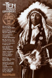
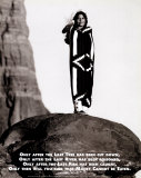
THE TEN INDIAN COMMANDMENTS
- Treat the Earth and all that dwell thereon with respect
- Remain close to the Great Spirit
- Show great repect for your fellow beings
- Work together for the benefit of all Mankind
- Give assistance and kindness wherever needed
- Do what you know to be right
- Look after the well-being of mind and body
- Dedicate a share of your efforts to the greater good
- Be truthful and honest at all times
- Take full responsibility for your actions
• more Prose posters
• Ten Commandments
|
|
|
|
|
|
|
Indian Prophecy
“Only after the last tree has been cut down, Only after the last river has been poisoned, Only after the last fish has been caught... only then will you realize that money cannot be eaten.”
|
|
|
|
|
|
|
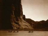
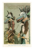
Dancing to Restore an Eclipsed Moon,
Edward S. Curtis
• dance posters
|
|
|
|
|
|
|
|
|
|
|
|
|
Explaining the Markings Used by the Indians on their Handicrafts such as Silver, Rugs, Pottery, etc.
• more alphabet posters
|
|
|
|
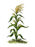
Corn - The precursor plant to what we know as corn today is believed to be a wild grass called teosinte, indiginous to central Mexico, and first cultivated (made part of the culture) about 7,000 years ago.
The wild grass, which has relatively few, small seeds that easily scatter when the plant is touched, was domesticated for traits of larger, easier to harvest seeds. The domesticated plant and seeds came to be known as maize by the indiginous peoples throughout North and South America, and a major food source.
• food posters
|
|
|
|
|
|
|
|
|
|
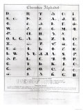
There are 85/6 characters in the Cherokee Alphabet devised by the Cherokee silversmith Sequoyah (c 1775-1843) who saw the advantages of the white peoples "talking leaves" and wanted the Cherokee to have the same ability to communicate. While some symbols in the Cherokee Alphabet resemble Latin alphabet letters the sounds are much different; the characters represent syllables. Sequoyah's writing system was made official by the Cherokee Nation in 1825.
• alphabet posters
|
|
|
|
|
|
|
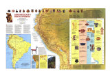
The Incas
(A.D. 1200 — A.D. 1533)
The Inca Indians ruled one of the largest and richest empires in the Western world. The Inca empire at its height stretched for 2,500 miles along the western coast of South America. And it included parts of the present-day countries of Peru, Bolivia, Colombia, Ecuador, Argentina and Chile. The empire was centered around the capital city of Cuzco, located high in the Andes mountains. From there the Inca ruler controlled the lives of his 6 million subjects.
The Inca began their rise to power in the year 1200. At that time, there had already been civilizations in the highlands of Peru for more than 1,000 years. It was from these earlier civilizations that the Incas learned to build fortress walls made from huge blocks of carefully carved stone. The Incas did not use mortar to hold the stones together. Instead, they carved the stones so precisely that they fit perfectly. And many of their walls still stand, despite the many earthquakes that have struck Peru. The Inca were farmers, and they found ways to grow corn and potatoes at elevations of 11,000 feet and higher. They build terraced fields along the steep mountainsides in order to increase the amount of land they could use for growing food. The Inca were also known for their fine cloth and beautiful jewelry. The vast Inca empire was held together by a system of stone highways. Swift runners used these highways to carry messages from the Inca ruler to all parts of the empire. Religion was very important to the Inca. Their most important god was Inti —the sun god. The Inca never developed a system of writing. But special officials kept detailed records with a device called a quipu (key-poo), which was a length of cord with knotted strings of different sizes and colors. Each color or knot stood for a different item.
In 1532, the Spanish explorer Francisco Pizarro arrived in South America. Within months, Pizarro and his army had slaughtered most of the Incas and taken the Inca ruler, Atahualpa, prisoner. And even though he paid a huge ransom of gold and silver, Atahaulpa was killed. The Spanish tried to destroy all traces of the Inca empire. But fortunately many Inca objects and ruins have survived the centuries — including the famous city of Machu Picchu ... (Text from a no longer available poster.)
• South America posters
• more Ancient Civilizations posters
• The Ancient Inca (People of the Ancient World)
|
|
|
|
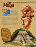
The Maya
(500 B.C. – 900 A.D.)
The Maya Indians built one of the world's most remarkable civilizations in the jungles of Central America. Like the ancient Greeks, who civilization was nearing its peak just as the Maya appeared, the Maya are known for their fabulous temples, and for their amazing knowledge of math and science. The Maya were the only Indians in America to develop a written language. Today, people come from all over the world to view the crumbling ruins of their once-great cities.
The Maya lived throughout Central America's Yucatan Peninsula in what are now the nations of Mexico, Guatemala, and Belize. They were a short, stocky people, with dark skin and black hair. They greatly admired sloping foreheads, and would frequently strap boards to babies' heads in order to flatten them. Maya life centered around the great cities, which were used for festivals, markets, and religious ceremonies. Strangely enough, almost no one lived in the cities. Only priests were allowed to live there for short periods of time. All other people lived in smaller communities around the cities, or on farms scattered throughout the countryside. The Maya grew crops such as corn, beans, squash, and tomatoes. They liked to dance, and they played a difficult game in which players had to hit a ball through a stone ring with their knees or hips.
Like the Greeks, the Maya worshipped many gods. They had rain gods, a sun god, a corn god, and gods of death and the underworld. The Maya were very interested in measuring and studying time. They invented a highly accurate calendar, which they used to help them track the movements of the sun, stars, and planets. Maya civilization began to decline around 800, as the Maya abandoned their cities one by one. Even today, no one really knows why this remarkable civilization suddenly ended.
Artwork depicts the Temple of the Inscriptions at Palenque, statue of the Maya leader Lord Pacal, and the Mayan calendar.
• more Ancient Civilizations posters
• more Maya posters
• Honduras posters
• Your Travel Guide to Ancient Mayan Civilization
|
|
|
|
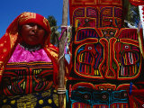
Kuna Indian Woman and Hand-Stitched Applique Textile (Mola), Panama
• more Panama posters
|
|
|
|
|
|
|
Francis La Flesche
b. 1857
d. 1932
Francis La Flesche, Omaha Indian and antropologist worked with the Bureau of American Ethnology.
|
|
|
|
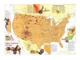
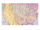
Indian removal was a nineteenth century policy of the government of the United States to relocate Native American tribes living east of the Mississippi River to lands west of the river.
The Indian Removal Act was signed into law by President Andrew Jackson on May 26, 1830.
The Five Civilized Tribes were the five Native American nations: the Cherokee, Chickasaw, Choctaw, Creek, and Seminole, which were considered civilized by Anglo-European settlers during the colonial and early federal period because they adopted many of the colonists' customs and had generally good relations with their neighbors.
• more Native American Cultures posters
|
|
|
previous page | top
|
|
I have searched the web for visual, text, and manipulative curriculum support materials - teaching posters, art prints, maps, charts, calendars, books and educational toys featuring famous people, places and events - to help teachers optimize their valuable time and budget.
Browsing the subject areas at NetPosterWorks.com is a learning experience where educators can plan context rich environments while comparing prices, special discounts, framing options and shipping from educational resources.
Thank you for starting your search for inspirational, motivational, and educational posters and learning materials at NetPosterWorks.com. If you need help please contact us.
|
|
|
|