|
|
|
|
|
|
|
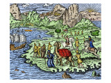
Navigation, the process of planning and executing a journey between a departure and destination point, is both an art and a science. The words navigate and navy, come from the Latin navigare, meaning “to sail”.
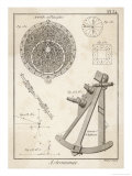
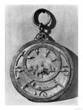
The tools of navigation include the astrolabe, an astronomical instrument that was the chief navigation tool until the compass in the 12th century, and the invention of the sextant, in the 18th century.
The astrolabe was used to locate and predict the positions of the Sun, Moon, planets and stars, determine local time given local longitude and vice-versa, surveying, and triangulation. Astrolabes were also used by astrologers to construct horoscopes.
A magnetic or mariner's compass is a navigational instrument for determining direction relative to the Earth's magnetic poles.
The quatrant, octant, and later the sextant, were generally used to measure the altitude of a celestial object above the horizon.
• Time and Astrolabe in the Canterbury Tales
• Bowditch Online
|
|
|
|
To circumnavigate means to travel (navigate) in a circle. The word is from geometry, a mathematical study of measurement, and usually is used to describe making a “great circle” around the Earth, or a continent.
The great circle distance on Earth's equatorial circumference is roughly 24,902 miles (40,000 km). The polar circumcumference is 24,860 miles which means the Earth “spreads out” around at the equator as it spins on its polar axis.
|
|
|
|
The Silk Road, or Route, is the network of trade routes across the Asian continent that connected Europe and the Mediterranean including North Africa with Asia.
The term “Silk Road” emphasizes the importance of silk fiber and fabric from China though other luxuries such as spices, perfume, and medicines as well as ideas, technologies and diseases were also traded.
|
|
|
|
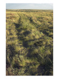
The Santa Fe Trail ran 1,200 miles from Franklin, Missouri to Santa Fe, New Mexico. It was active between 1822 to 1860s, when the opening of a southwest railroad route ended the economic viability of wagon and pack animal caravans. Ruts in the prairie can still be seen at the Santa Fe Trail Remains National Historic Landmark, near Dodge City, Kansas.
FYI - The Santa Fe, the Oregon Trail and the California Trails either passed through or originated in Jackson County, Missouri (Kansas City), jumping off from Westport - (if you order a Global PathMarker image it will be shipped from the Westport PO).
|
|
|
|
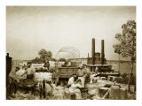
On May 22, 1843, a massive wagon train of 1,000 settlers and 1,000 head of cattle, set off on the Oregon Trail from Independence, Missouri on a 2,000 miles journey that was to take five months. Known as the “Great Emigration,” the expedition came two years after the first much smaller party of settlers made the long, overland journey to Oregon.
The giant wagon train followed the Sante Fe Trail for some 40 miles out of Independence and then turned northwest to the Platte River in the Nebraska Territory, following the Platte along its northern route to Fort Laramie, Wyoming. The wagon train passed through the Rocky Mountains at the broad, level South Pass to the basin of the Colorado River, southwest to Fort Bridger, northwest across a divide to Fort Hall on the Snake River, then to Fort Boise and finally cutting a trail through the heavily wooded Blue Mountains into Oregon.
An estimated 400,000 people used the Oregon Trail and its three destination offshoots (California, Bozeman and Mormon Trails) until the railroads brought its end in the 1870s.
|
|
|
|
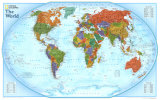
National Geographic’s decorative and educational “World Explorer Map” depicts nations in sharp, rich colors, and mountains in shaded relief. The precise, up-to-date political map is artistically detailed with charts describing world land masses and populations. Using the Winkel Tripel projection technique, which reduces the distortion of land masses near the poles, cartographers created an accurate rendering of a sphere on a flat surface. Inset charts list the largest cities and countries, printed at a scale of 1 inch to every 820 miles.
|
|
|
|
Discovering the Potato -
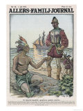
The first Europeans to see the potato was Pedro de Cieza de Leon (1518–1560) Spanish Conquistador and historian, in 1540. Sir Walter Raleigh introduced the potato, a food that was considered fit only for the poor, to Ireland in 1589.
• more food posters
• potato clay & potato stamps for crafts
|
|
|
|
Moon Landing, July 20, 1969
"Houston, Tranquility Base here. The Eagle has landed." Buzz Aldrin
“That’s one small step for a man,
one giant leap for mankind.” Neil Armstrong
• Astronaut posters
• moon posters
|
|
|
|
|
|
previous page | top
history > EXPLORING | explorers list > a | b | c | d | e | f | g |
h | i-j-k | l | m | n-o | p | q-r | s | t-u | v | w-x-y-z < social studies
|
|
I have searched the web for visual, text, and manipulative curriculum support materials - teaching posters, art prints, maps, charts, calendars, books and educational toys featuring famous people, places and events - to help teachers optimize their valuable time and budget.
Browsing the subject areas at NetPosterWorks.com is a learning experience where educators can plan context rich environments while comparing prices, special discounts, framing options and shipping from educational resources.
Thank you for starting your search for inspirational, motivational, and educational posters and learning materials at NetPosterWorks.com. If you need help please contact us.
|
|
|