|
|
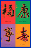
China and Chinese Culture Posters, Prints, Maps & Charts, pg 1/2
curriculum resources for social studies classroom, home schoolers and themed decor.
|
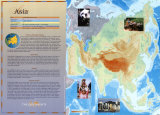
geography > Asia > CHINA & CHINESE CULTURE 1 | 2 < China Cities < social studies
|
|

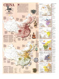
China Map
(35º0'0"N 103º0'0"E)
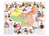
Not only is China the third largest country in the world today - almost 3.7 million square miles, and has the largest population - more than 1.3 billion people, it is the world's oldest contiuous civilization with over five thousand years of art, philosophy, and inventions. China as a geographic and cultural entity located in continental East Asia with some outer territories in Central Asia and offshore islands in the Pacific Ocean.
Since 1949 “China” has been divided de facto between the People's Republic of China governing mainland China and numerous islands; Hong Kong since 1997 and Macao since 1999; and the Republic of China, governing Taiwan Province and several outlying islands of Fukien Province.
The 2008 Summer Olympics were hosted by China in Beijing.
|
|
|
|
|
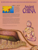
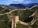
Ancient China –
(2000 B.C. — A.D. 220)
Like the civilizations of the Fertile Crescent, Chinese civilizations grew up in the valleys surrounding two great rivers — the Yellow River and the Yangtze River. The rich, fertile plain that lies between these two rivers contains about 90 percent of China's land that is usable for farming. And it was here that China's first cities appeared, around 2000 B.C. . . .
• more Ancient Civilizations posters
|
|
|
|
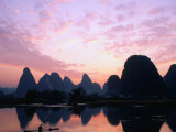
The landscape along the Li River in China is called ‘karst’, a term for a landscape shaped by the dissolution of bedrock layer(s), resulting in distinctive surface features and underground drainages.
FYI ~ Karst topography is visible in the Kras Plateau border area of Italy and Slovinia, and in southern Missouri and northern Arkansas Ozark region of the United States.
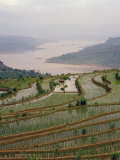
China's Yangtze, the longest river in Asia, has seen human activity in the Three Gorges area as far back as 27,000 years ago. The Yangtze experiences major flooding and is very polluted.
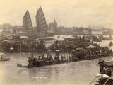
Shanghai, the most populous city in China, sits at the mouth of the Yangtze River. Other cities on the Yangtze are Chongqing, Wuhan, and Nanjing.
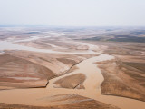
China's Yellow River, the 6th longest river in Asia, is called the “the cradle of Chinese civilization”. The Yellow River has frequent devastating flooding, and has earned the name “China's Sorrow”.
The Yellow River rises in western China and flows into the Bohai Sea. Major cities along the Yellow River are Lanzhou, Yinchuan, Wuhai, Baotou, Luoyang, Zhengzhou, Kaifeng, and Jinan.
|
|
|
|
The Pearl River is an extensive river system in southeastern China that share a common delta, the Pearl River Delta. The mouth of the Pearl River forms the Zhujiang Kou bay in the delta separating Macau and Zhuhai from Hong Kong and Shenzhen.
The Pearl River gained its name for the pearl coloured shells that lie at the bottom of the river where it flows through the city of Guangzhou (Canton). Today the Pearl River is considered one of the world's most polluted waterway.
|
|
|
|
|
|
|
|
|
|
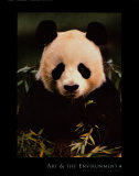
Only an estimated 3,000 Giant Pandas, a bear native to China, survive into the 21st Century. There are approximately 250 pandas in captivity; the numbers in the wild appear to be rising due to intensive conservation efforts. Even though giant pandas are classified as carnivors, 99% of their diet is bamboo, a woody perennial evergreen in the grass family.
• animal posters
• environment posters
|
|
|
|
|
|
|
Long cultivated in China, some ginkgo trees planted at temples are believed to be over 1,500 years old.
|
|
|
|
|
|
|
|
|
|
|
|
I have searched the web for visual, text, and manipulative curriculum support materials - teaching posters, art prints, maps, charts, calendars, books and educational toys featuring famous people, places and events - to help teachers optimize their valuable time and budget.
Browsing the subject areas at NetPosterWorks.com is a learning experience where educators can plan context rich environments while comparing prices, special discounts, framing options and shipping from educational resources.
Thank you for starting your search for inspirational, motivational, and educational posters and learning materials at NetPosterWorks.com. If you need help please contact us.
|
|
|