|
|
|
|
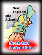
| North East States |
|
|
GEOGRAPHY TEACHING RESOURCES
|
|
|
|
|
|
|
|
|
|
|
|
|
|
|
|
|
|
|
|
|
|
|
|
|
|
|
|
|
|
|
|
|
|
 |
|
| The US Census Bureau describes the Northeast states as the New England and Mid Atlantic regions. Geographically the northeastern United States includes Delaware, Maryland, Virginia, and West Virginia, however they are in the South Atlantic region of the southern states for enumeration purposes. An * denotes the original 13 colonies. |
|
|
|
|
Midwest States
|
|
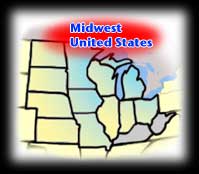 |
The north central states of the United States are referred to as the Midwest. The US Census Bureau delineates the the East North Central region (the Great Lakes States) and the West North Central region (the Great Plains States). |
|
|
|
|
Southern States Posters *original 13 colonies
|
|
South Atlantic
*Delaware,
Florida,
*Georgia,
*Maryland,
*North Carolina,
*South Carolina,
*Virginia,
West Virginia |
East South Central
Alabama,
Kentucky,
Mississippi,
Tennessee
West South Central
Arkansas,
Louisana,
Oklahoma,
Texas
|
|
|
|
|
Western States Posters
(**coming) |
|
Mountain
**Arizona,
**Colorado,
**Idaho,
**Montana,
**Nevada,
**New Mexico,
**Utah,
**Wyoming |
Pacific
**Alaska,
**California,
**Hawaii,
**Oregon,
**Washington |
|
|
|
|
|
United States Maps
Maps of the United States colonial period, themes of territorial growth, battlegrounds, geology, political, physical, biggest cities, Native American, national parks, federal lands, food, election results.
|
|
|
|
|
|
United States Cities
New Orleans and more...
A city is defined as “an urban area of high population density with some degree of self-government”, differentiated from towns, villages, and hamlets by size, importance or legal status. The word urban originally described the view of life from Rome - smooth, literate and non-barbaric. The opposite of the Latin Urbanus is Rusticus, or rural.
|
|
|
|
|
|
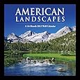
National Parks Posters
A selection of posters and art prints celebrating the natural wonders and preserving history around the world.
The first U.S. national park was Yellowstone in the state of Wyoming, established in 1872.
|
|
|
|
|
|
|
|
|
previous page | top
|
|
I have searched the web for visual, text, and manipulative curriculum support materials - teaching posters, art prints, maps, charts, calendars, books and educational toys featuring famous people, places and events - to help teachers optimize their valuable time and budget.
Browsing the subject areas at NetPosterWorks.com is a learning experience where educators can plan context rich environments while comparing prices, special discounts, framing options and shipping from educational resources.
Thank you for starting your search for inspirational, motivational, and educational posters and learning materials at NetPosterWorks.com. If you need help please contact us.
|
|
|