|
|
|
|
|
|
|
|
|
|
|
|
BOOKS ABOUT MAPS & MAPMAKING
|
|
|
|
|
|
|
|
|
|
|
|
|
|
|
|
|
|
|
|
|
|
|
|
|
|
|
|
|
|
|
 |
|
|
|
United States Maps, Posters & Charts
for the social studies & geography classrooms, home schoolers, theme decor.
|
social studies > maps 1 | 2 | 3 | 4 | US MAPS < US region/state | NG Maps | ocean maps < geography
Maps of the United States colonial period, themes of territorial growth, battlegrounds, geology, political, physical, biggest cities, Native American, national parks, federal lands, food, election results.
|
|
|
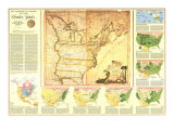
Territorial Growth Map from National Geographic reproduces a 1784 map. It is an excellent overview describing the issues that were at the center of how land was acquired, usurped, and annexed as the United States took form.
|
|
|
|
The United States in 1792
Legend: The Mississippi was then the western boundary of the United States, but we had a claim on the Oregon country. England, Spain and Russia also claimed Oregon.
• more Revolutionary War posters
|
|
|
|
|
|
|
|
|
|
United States Physical Map from National Geographic is printed at a scale of 1 inch to every 89 miles.
|
|
|
|
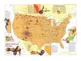
United States Map featuring state capitals and icons illustrating a state's notable features (Michigan- cars, Montana- grizzly bear).
|
|
|
|
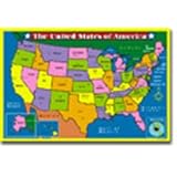
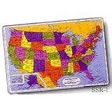
USA Map in crayon-bright blocks of color, state names and borders, international borders, state capitals, secondary cities, and an inset map of Alaska and Hawaii.
|
|
|
|
|
|
|
|
|
|
United States Political Map from National Geographic, printed at a scale of 1 inch to every 71 miles.
|
|
|
|
U.S. Map Floor Puzzle
3' x 2' floor puzzle with 58 large, easy-to-manage pieces. Matching poster/work mat included, durable storage box.
|
|
|
U.S. Map Wood Puzzle -
Learn states' names and their capitals with puzzle pieces marked with names of states and the state capitals printed on puzzle board.
|
|
|
|
U.S. Map Learning Placemat
• U.S. placemat features all fifty states, their capitals, major cities, prominent rivers, etc.
• These placemats offer a delightful way for children of all ages to master new subjects and for adults to brush up on old ones.
• Each is brightly colored, measures a full 12 x 17.5" and is custom laminated with a non-glare laminate on the front and a write-on/wipe-off laminate on the back.
• The back of each placemat features learning exercises based on the front.
|
|
|
Easy to use product allows you to create a huge USA mural map measuring 27' wide by 16' tall (Continental US). Ideally suited for schools, the eight section stencil has holes which define detailed borders of the 50 states and the five Great Lakes. Playground tested.
|
|
|
previous page | top
maps 1 | 2 | 3 | 4 | US maps < US regions |
|
|
I have searched the web for visual, text, and manipulative curriculum support materials - teaching posters, art prints, maps, charts, calendars, books and educational toys featuring famous people, places and events - to help teachers optimize their valuable time and budget.
Browsing the subject areas at NetPosterWorks.com is a learning experience where educators can plan context rich environments while comparing prices, special discounts, framing options and shipping from educational resources.
Thank you for starting your search for inspirational, motivational, and educational posters and learning materials at NetPosterWorks.com. If you need help please contact us.
|
|
|