|
|
United States Cities Educational Posters & Art Prints
for social studies classroom, home schoolers, and as theme decor for office and studio.
|
geography> Cities of the World | US CITIES | Americas Cities < social studies
|
|
A city is defined as "an urban area of high population density with some degree of self-government", differentiated from towns, villages, and hamlets by size, importance or legal status. The word urban originally described the view of life from Rome - smooth, literate and non-barbaric. The opposite of the Latin Urbanus is Rusticus, or rural. The early US had a primarily rural population of nearly 90%, in the first decade of the third millenium the urban population of the US is 80% of the total.
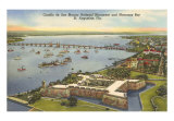
The first permanent European settlements in the "New World" now governed by the United States are San Juan, PR (1512), St. Augustine, FL (1565), Santa Fe, NM (1607), and Jamestown, VA (1607). All except Santa Fe, which was established after the Roman custom of building the capital in the center of the territory you intended to govern, were founded where there was safe anchorage for ships from Europe.
Other early American cities: Boston (1630), New Amsterdam (1653) which became New York in 1665, Charleston, SC (1670-80), Philadelphia (1682), Detroit (1701), New Orleans (1718), and Los Angeles (1777), mostly followed the formula of having water access for transportation.
Gradually these settlements changed from being the storehouses and distribution points of imported goods for colonists and the marketplace where produce from the surrounding areas were brought for export, to manufacturing centers that produced and redistributed durable goods. New cities of importance after the Revolutionary War grew with the development of canals, improved roads, and then railroads include Pittsburg, PA (Allegheny, Ohio and Monongahela rivers), Cincinnati, OH (Ohio River), Buffalo, NY (Erie Canal) and St. Louis, MO (Mississippi River).
Successful cities depended not only on good connections to distant places but also a concentration of talented people with initiative and enough capital to generate commerce which draws more talent, more initiative and more money.
US Geological Survey - Urban Growth in American Cities
|
|
|
|
|
|
 |
Atlanta, Georgia - 4th of July Poster
available at-
Art.com
AllPosters.com
• Georgia posters
|
|
|
|
|
 |
Sailing in Boston Poster
available at-
Art.com
• Massachuesetts posters
|
|
 |
Chicago Panorama Poster
available at-
Art.com
AllPosters.com
barewalls.com
• more Illinois posters
|
|
 |
Dallas, Texas Art Print
available at-
Art.com
AllPosters.com
barewalls.com
• more Texas posters
|
|
|
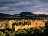
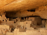
Mesa Verde, cliff dwellings which are structures built within caves and under outcropping in cliffs, in the southwest corner of US state of Colorado.
The dwellings were built and inhabited by the Anasazi between 550 and 1300 AD. They are thought to be the largest cliff dwellings in North America.
The site was discovered in the latter half of the 19th century; President Teddy Roosevelt placed Mesa Verde under protection of a national park due to vandalism. Mesa Verde is also designated as a UNESCO World Heritage site.
The name Mesa Verde is Spanish for “green table”.
• more Native America posters
|
|
|
 |
Detroit, Michigan from Space Poster
available at-
Art.com
AllPosters.com
barewalls.com
• Michigan posters
|
|
 |
Kansas City from Space Poster
available at-
AllPosters.com
Art.com
barewalls.com
• Missouri posters
|
|
 |
Los Angeles Panorama Poster
available at-
Art.com
AllPosters.com
barewalls.com
|
|
 |
Miami Beach Florida Poster
available at-
Art.com
AllPosters.com
• Florida posters
|
|
 |
New Orleans, Louisiana Art Print
available at-
barewalls.com
AllPosters.com
• Louisiana posters
|
|
 |
New York Panorama Poster
available at-
Art.com
AllPosters.com
• as a puzzle from barewalls.com
|
|
|
|
|
|
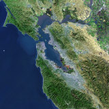
San Francisco, located on the northern end of the San Francisco Peninsula, separating the San Francisco Bay from the Pacific Ocean, is the fourth most populous city in California (LA, San Diego, San Jose) and the 12th most populous city in the United States.
The Spanish established a fort, the Presidio of San Francisco, followed by a mission, Mission San Francisco de Asís, in the spring of 1776. By 1821 the settlement, called Yerba Buena, was part of Mexico. In 1847 the name was changed to San Francisco, shortly after the first American flag was raised.
San Francisco became the entry port for the California Gold Rush in 1848 and suffered a devestating earthquake in 1906. Symbolic of San Francisco is the Golden Gate Bridge (1937) spanning the opening to the bay and the ocean.
|
|
|
|
|
|
 |
Washington, D.C Poster
available at-
AllPosters.com
Art.com
barewalls.com
• Political Process poster series
|
|
|
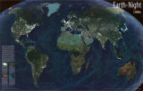
Earth at Night
Satellite based image highlights the glowing lights cities generate at night
• more Earth from Space posters
|
|
|
previous page | top
|
|
I have searched the web for visual, text, and manipulative curriculum support materials - teaching posters, art prints, maps, charts, calendars, books and educational toys featuring famous people, places and events - to help teachers optimize their valuable time and budget.
Browsing the subject areas at NetPosterWorks.com is a learning experience where educators can plan context rich environments while comparing prices, special discounts, framing options and shipping from educational resources.
Thank you for starting your search for inspirational, motivational, and educational posters and learning materials at NetPosterWorks.com. If you need help please contact us.
|
|
|