|
|
Canada & Canadian Culture Geography Posters & Prints
for geography, social studies classrooms; home schoolers.
|
geography > North America > CANADA & CANADIAN CULTURE | Provinces < social studies
|
|
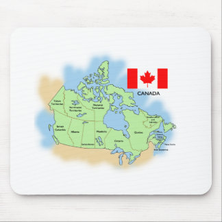
Canada, as the world's second-largest country by total area, occupies most of northern North America. Canada extends from the Atlantic Ocean to the Pacific Ocean and northward into the Arctic Ocean. Canada's land borders are with the United States along the south and to the northwest with Alaska. The name Canada comes from a Iroquoian word for “village” or “settlement” and was adopted by Jacques Cartier for the land he was exploring for France in 1535.
Passage along the northern Canadian coastline is ground for international dispute. The search for a northern commerical sea route, the goal of explorers between the end of the 15th century and the 20th century, were thwarted because of the pack ice blocking a clear water passage. One of the results of climate change and the rising global temperatures is that as of September 2007 the Northwest Passage pack ice has melted and opened the sea route through the Arctic Ocean along the northern coast of North America for the “first time since records began in 1978” according to the European Space Agency.
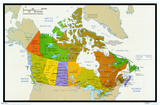
Canada is divided into ten provinces - Newfoundland and Labrador, New Brunswick, Nova Scotia, Prince Edward Island, Quebec, Ontario, Manitoba, Saskatchewan, Alberta, British Columbia; and three territories - Nunavut, Northwest Territories, and Yukon Territory.
The federal capital of Canada is Ottawa; Toronto is the largest city (also the fifth largest city in North America after Mexico City, NYC, Los Angeles, Chicago), and Montreal is one of the largest French speaking cities in the world.
The federal constitutional monarchy of Canada was founded as a union of British and former French colonies in 1841. Beginning in 1867, gradual independence from the United Kingdom was achieved in 1982. Queen Elizabeth II of the United Kingdom, is also the Canadian Head of State. Canada Day is celebrated July 1. Canada uses both English and French as official languages.
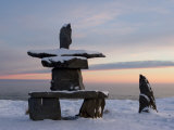
There is evidence of Aboriginal peoples habitation from more than 25,000 years ago in the Yukon area and 9,500 years in the Ontario area. Above the Arctic Circle the stone landmarks called inuksuk were built in an environment with few natural features.
The first European settlers were Vikings c.1000 AD at L'Anse aux Meadows on the island of Newfoundland; the British and French explorers lead to permanent settlements between 1605 and 1610 in Nova Scotia and Quebec.
|
|
|
|
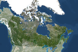
Satellite image of Canada shows Hudson Bay and its southern offshoot James Bay; Baffin Bay, between Atlantic & Arctic Ocean, usually filled with ice (Greenland is to the east); the Saint Lawrence River drains the Great Lakes into the Atlantic Ocean at the Gulf of Saint Lawrence. Sixty percent of the world's freshwater lakes are in Canada, many in the area of rock known as the Canadian Shield that had been scoured clean by the last ice age.
|
|
|
|
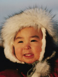
Inuit is a general term for culturally similar indigenous peoples inhabiting the Arctic regions of Alaska, Greenland, and Canada. Nunavut is the territory whose name means "the land of the Inuit".
• igloo poster
• National Film Board of Canada
• Native Americans Posters
|
|
Shanawdithit
b. c. 1801
d. 6-6-1829; St. Johns, Newfoundland (tuberculosis)
Shanawdithit was the last recorded surviving member of the Beothuk people who lived throughout the island of Newfoundland.
|
|
|
|
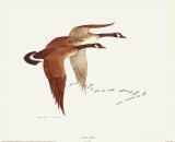
Canada Geese flying in V-shaped formation are a familiar signal of the seasonal transitions into spring and autumn.
• bird posters
|
|
|
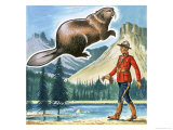
Beaver, the largest rodent in North America (and the third largest rodent in the world, after the South American capybara and the Eurasian beaver) is also an emblem of Canada. The beaver fur was prized in Europe and brought trappers and traders to North America.
|
|
|
|
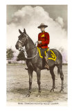
Royal Canadian Mounted Police are famous for “always getting their man” and the distinctive scarlet ceremonial uniform and Stetson hat.
• horse posters
|
|
|
|
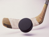
The modern game of ice hockey was first organized by McGill University students in 1875.
The 2010 Winter Olympics were hosted by Vancouver, BC.
|
|
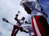
The game of la crosse (the stick), a team sport of Native American origin, is considered the national summer sport of Canada.
FYI- Zebulon Pike saw Indians playing a game like la crosse in an area of current day Wisconsin and called the place Prairie La Crosse. And Chief Pontiac set up a la crosse game outside Fort Michilimackinac to celebrate the King George III's birthday - the players gradually played their way close to the open gates and then rushed in to massacre the British soldiers and traders.
|
|
|
|
Up to 5000 Acadians were deported from Acadia, present day Canadian Maritime provinces of Nova Scotia (renamed in honor of Scotland by the British), New Brunswick, and Prince Edward Island, and some of the American state of Maine, by the British in 1755.
The Acadians were the descendants of 17th-century French colonists; many settled in Louisiana where they became known as “Cajuns”.
American author Henry Wadsworth Longfellow's poem Evangeline (1847) is a fictional account of the expulsion.
|
|
|
|
Jacques Cartier
b. 12-31-1491; St. Malo, Brittany, France
d. 9-1-1557; St. Malo
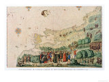
France based its claims to the rich lands of Canada on the exploration of Jacques Cartier. He lead the first European expedition up the St. Lawrence River, which became an important passageway into the interior of North America. He detailed accounts of his geographical discoveries, the Indians, and the plants and animals of the New World were published in French, English, and Italian. They stimulated many later voyages to North America.
In 1534, King Francis I sent Cartier to North America to search for the fabled Northwest Passage to China. Many Europeans hoped they could reach the Orient by sailing north of North America. Cartier's expedition landed on the Gaspé Peninsula in Canada. He claimed the peninsula for France. There he met a group of Iroquois Indians who told him of precious jewels and metals farther northwest, which whetted his appetite for exploration. Cartier established friendly relations with the Indians on this expedition, finding natives who would later serve as interpreters.
Cartier returned to Canada the next year. Sailing along the northern coast of the Gaspé Peninsula, he entered a bay, which he named for St. Lawrence because the expedition arrived there on the saint's feast day. From the bay, he sailed up the great river to the foot of a mountain he called Mont Réal, or “Mount Royal.” The city of Montreal was founded on this site. Because Cartier claimed the region for France, Montreal grew into the second-largest French-speaking city in the world. .... Winter stopped Cartier's exploration on this second expedition. He and his crew returnd down the river to what is now Quebec City, where their ships were trapped by ice and they had to spend the winter. The Frenchmen suffered greatly from cold and hunger during the long Canadian winter. Most of them became ill with scurvy, a disease caused by lack of vitamin C. Before Cartier learned that a brew of white cedar bark would cure the disease, 25 men died.
On his third voyage ot America, Cartier searchd for gold and spices that Indians said existed to the west. The Indians became hostile when they realized the French intended to stay in Canada. They killed many of Cartier's men, and he returned to France after spending another hard winter in Canada. (text from no longer available poster in series)
• North American Continent poster
|
|
|
|
|
|
|
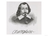
Samuel de Champlain
b. 1567; Brouage or La Rochelle, Aunis, France
d. 12-25-1635; Quebec City
Samuel de Champlain, the “father of New France,” founder of Quebec City, opened North America to French fur trade. Champlain was born in the seaport town of Brouage on France's west coast and naturally became a salior, progressing to navigator and mapmaker. Champlain would spend several months or years exploring North America in the area of present day Quebec and the area of the US where Lake Champlain, named for him, in 1609; and then return to France to find investors for more exploration.
|
|
|
|
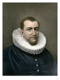
David Thompson
b. 4-30-1770; London, England
d. 2-10-1857; Montreal, Canada
Fur trader, surveyor, and map-maker, David Thompson explored North America west of Hudson Bay and Lake Superior, across the Rocky Mountains to the source of the Columbia River, and followed the length of the Columbia to the Pacific Ocean. He has been described as the “greatest land geographer who ever lived” and known to some native peoples as “Koo-Koo-Sint” or “the Stargazer”.
FYI ~ Thompson apprenticed to the Hudson Bay Company at age 14, clerking in present day Manitoba; Thompson was the creator of maps used by Lewis and Clark.
|
|
|
|
Jean Paul Lemieux (1904–1990) is one of the foremost painters of twentieth century Québec.
• winter posters
|
|
|
previous page | top
CANADA & CANADIAN CULTURE | Provinces
|
|
I have searched the web for visual, text, and manipulative curriculum support materials - teaching posters, art prints, maps, charts, calendars, books and educational toys featuring famous people, places and events - to help teachers optimize their valuable time and budget.
Browsing the subject areas at NetPosterWorks.com is a learning experience where educators can plan context rich environments while comparing prices, special discounts, framing options and shipping from educational resources.
Thank you for starting your search for inspirational, motivational, and educational posters and learning materials at NetPosterWorks.com. If you need help please contact us.
|
|
|