|
|
|
|
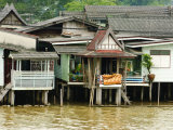
The Chao Phraya is a major river in Thailand. The river begins at the confluence of the Ping and Nan rivers then flows to Bangkok and out into the Gulf of Thailand.
The name of the river translates as “River of Kings”.
|
|
|
|
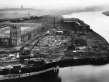
Scotland's River Clyde, flowing through Glasgow, was an important river for shipbuilding, trade, and water power for industry.
David Dale and his son-in-law Robert Owen operated cotton mills on the river.
|
|
|
|
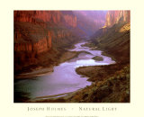
The Colorado River in southwestern United States and northwestern Mexico, is approximately 1,450 miles long and drains a part of the arid regions of the western slope of the Rocky Mountains.
The Colorado River has carved many canyons. The most noted is the Grand Canyon, a steep sided canyon 277 miles long, up to 18 miles wide and to a depth of 6,000 feet, into the Colorado Plateau. The river exposed 2 billion years of geological history by eroding through layers of rock for at least 17 million years.
The Grand Canyon of the Colorado was first seen by Spanish explorers in the Francisco Coronado expedition of 1539-40. In 1869 John Wesley Powell lead the first passage of European-Americans through the Grand Canyon. The area is designated as a national park.
The Hoover Dam (construction 1931-36) was built across the Colorado River at Black Canyon, creating Lake Mead, to control floods, provide irrigation water and produce hydroelectric power. In the 1960 the Glen Canyon Dam created Lake Powell. Other dams also capture the water of the Colorado River for irrigation meaning the river no longer flows to its natural course through its delta into the Gulf of California in Mexico.
FYI ~ the word colorado is from Spanish meaning colored or reddish.
|
|
|
|
The Columbia, the largest river in the Pacific Northwest region of North America, rises in the Rocky Mountains of British Columbia, Canada, eventually flowing through the U.S. state of Washington and then forming most of the border between Washington and the state of Oregon to the south before emptying into the Pacific Ocean.
The Columbia is notable for it steep gradient and has many hydroelectric dams on the main stream and tributaries, producing more hydroelectric power than any other North American river.
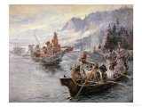
Notable explorers of the Columbia include Robert Gray in 1792 who named the river after his ship the Columbia Rediviva, the American Lewis & Clark Expedition, 1803–05, and David Thompson who travelled from British Columbia in 1811.
The Columbia's watershed has seen human habitation for more than 15,000 years, with salmon fishing starting about 3,500 years ago.
|
|
|
|
Congo River, also known as the Zaire, has the distinction of being the deepest river (750 feet), the 2nd largest in discharge (after the Amazon), its length is the 9th longest. Because the Congo straddles the Equator there is always a rainy season somewhere in its large watershed.
The Congo flows from the highlands and mountains of the East African Rift, through the African rainforest and empties into the Atlantic Ocean. The series of canyons and falls (the Livingstone Falls) block navigation from the Atlantic coast, thwarting easy exploration of the interior of Africa. This section of the river was bypassed in the late 19th century by constructing a railroad.
Near a geological feature called Pool Malebo, a lake-like widening of the Congo River, the cities of Brazzaville, Republic of the Congo, is located on the north side of the river, across from Kinshasa, Democratic Republic of the Congo, on the south side.
The name Congo comes from the Kingdom of Kongo which inhabited the lands at the mouth of the river from 1400-1914.
FYI - The Congo is generally accepted as the setting for Joseph Conrad's 1902 novel Heart of Darkness , which revealed the brutality of European exploration and colonization of the Congo. , which revealed the brutality of European exploration and colonization of the Congo.
|
|
|
|
previous page | top | next
landforms > rivers a-b | C | d | e-f-g-h-i-j | k-l | m | n | o | p | q-r | s | t-u-v | w-x-y-z
|
|
I have searched the web for visual, text, and manipulative curriculum support materials - teaching posters, art prints, maps, charts, calendars, books and educational toys featuring famous people, places and events - to help teachers optimize their valuable time and budget.
Browsing the subject areas at NetPosterWorks.com is a learning experience where educators can plan context rich environments while comparing prices, special discounts, framing options and shipping from educational resources.
Thank you for starting your search for inspirational, motivational, and educational posters and learning materials at NetPosterWorks.com. If you need help please contact us.
|
|
|