|
|
|
|
|
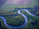
Red River of the North flows northward from the confluence of the Bois de Sioux and Otter Tail rivers forming the border between North Dakota and Minnesota. It continues into Lake Winnipeg (Netley-Libau marsh delta) in Manitoba, Canada and the watershed continues draining from the lake to the Hudson Bay through the Nelson River.
The river is usually slow and small, meandering across the ancient lakebed. However, in the case of heavy snows or rains, high water spreads across the old lakebed in “overland flooding”. There have been a number of catastophic floods, recently 1950, 1997, 2009, and 2011, that are made worse by the snowmelt starting in the warmer south and the northward flowing waters are dammed by ice.
|
|
|
|
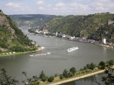
The Rhine River flows northward from the Alps in eastern Switzerland, forming borders with Liechtenstein and then Austria, through Lake Constance, Germany, France and the Netherlands, emptying into the North Sea at the Rhine-Meuse Delta.
Large cities on the Rhine include Basel, Bonn, Cologne, Dusseldorf, Rotterdam, Strasbourg, Utrecht.
Among people associated with the Rhine River are mystic Hildegard von Bingen, composer Richard Wagner and Das Rheingold opera inspired by the Nibelungenlied legends, and Heinrich Heine's Die Lore-Ley poem about Lorelei myth.
American poet Walt Whitman called the Rhine “The most beautiful river in the world.”
|
|
|
|
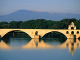
The Rhone River, one of the major rivers of Europe, originates at the Rhone Glacier in Switzerland and flows through Lake Geneva and southeastern France to the Mediterranean. The Rhone follows a north-south cleft separating the Alps from the Massif Central.
The major French city of Lyon is on the Rhone.
At Arles, the river divides into two branches, the Great Rhone (French: Grand Rhône) and the Little Rhone (Petit Rhône). The resulting delta constitutes the Camargue region.
|
|
|
|
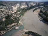
Rio Grande, US & Mexico, (known in Mexico as the Río Bravo del Norte, or simply Río Bravo) flows from southwestern Colorado in the United States to a small sandy delta at the Gulf of Mexico near Brownsville, TX. Along the way it serves as a natural border between the U.S. state of Texas and the Mexican states of Chihuahua, Coahuila, Nuevo León, and Tamaulipas.
The name means “big river” and “fierce river of the north.”
|
|
|
|
previous page | top | next
rivers | a-b | c | d | e-f-g-h-i-j | k-l | m | n | o | p | Q-R | s | t-u-v | w-z-y-z
|
|
I have searched the web for visual, text, and manipulative curriculum support materials - teaching posters, art prints, maps, charts, calendars, books and educational toys featuring famous people, places and events - to help teachers optimize their valuable time and budget.
Browsing the subject areas at NetPosterWorks.com is a learning experience where educators can plan context rich environments while comparing prices, special discounts, framing options and shipping from educational resources.
Thank you for starting your search for inspirational, motivational, and educational posters and learning materials at NetPosterWorks.com. If you need help please contact us.
|
|
|