|
|
|
|
|
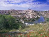
The Tagus, the longest river on the Iberian Peninsula flows from the southwestern end of the Iberian Mountain System through Spain, then forms a small part of the border between Spain and Portugal, before crossing Portugal and flowing into the Atlantic Ocean at Lisbon.
The lower part of the Tagus follows a fault line responsible for many earthquakes with major events in 1309, 1531, and 1755.
FYI - the longest bridge in Europe is the Vasco de Gama bridge near Lisbon.
|
|
|
|
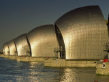
The River Thames, which has supported human activity for milleninia, rises in the west-central Cotswold Hills of Gloucstershire and flows through southern England emptying to the North Sea at the Thames Estuary, the world's second largest tidal movement (first, Bay of Fundy).
Because the Thames is a tidal river, London is under the threat of severe flooding when the conditions of weather and high tide push water up the Thames from the sea. On December 7, 1663 Samuel Pepys wrote in his diary, 'There was last night the greatest tide that was ever was remembered in England to have been in this River, all Whitehall having been drowned.'
The word Thames is from the Middle English “Temese” and derived from the Celtic name for the river; scholars link the word to Sanskrit and Irish words that means “dark”.
The Thames Tunnel, engineered by Marc Brunel, was the world's first underwater tunnel.
|
|
|
|
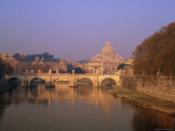
The Tiber River is the third-longest river in Italy. It rises in the Apennine mountains and flows to the Tyrrhenian Sea off the west coast of Italy.
According to legend, the city of Rome was founded in 753 BC on the banks of the Tiber.
|
|
|
|
The Tigris (eastern) and the Euphrates (western) are the two rivers that define the area of Mesopotamia, the “cradle of civilization”. The Greeks called the area Mesopotamia, literally “between the rivers”.
The Tigris and Euphrates Rivers are part of the “Fertile Crescent”, an historic Middle East region that corresponds to present-day Egypt, Israel, West Bank, Gaza strip, and Lebanon and parts of Jordan, Syria, Iraq, south-eastern Turkey and south-western Iran.
Both the Tigris and Euphrates rise in eastern Turkey, flowing nearly parallet to one another before merging shortly before flowing into the Persian Gulf.
|
|
|
|
The Ural River, which rises on the southeastern side of Ural Mountains, flows through Russia and Kazakhstan into the Caspian Sea.
Due to the course of the Ural River, it is arguably a geographic boundary between Asia and Europe.
The vast wetlands delta of the Ural River is called a digitate, a tree like shape that occurs when a slow moving river enters a calm sea.
FYI ~ Catherine the Great decreed the name of the river Ural in 1775; it's original name was Yaik, Ptolemy called it Jajykon on a map from the 2nd century.
|
|
|
|
The Vistula River is the longest river in Poland, rising in the Carpathian Mountains and flowing north into the Gdansk Bay on the Baltic Sea. Scientists predict it is likely most of the Vistula Delta region, which is below sea level, will be flooded due to the sea level rise caused by climate change by 2100.
The Vistula was part the Amber Road, an ancient trade route through Europe and Asia that connected northern Africa with the Baltic Sea.
Kraków and Warsaw are among the important Polish cities on the banks of the Vistula.
|
|
|
|
The Volga is the largest river in Europe in terms of length, discharge, and watershed, is considered the national river of Russia. It rises between Moscow and St. Petersburg, and flowing eastward carves a wide half circle through central Russia before bending toward the Don (“the big bend” where Volgograd, formerly Stalingrad, is located) and on to the Caspian Sea.
The fertile Volga river valley is an important farming area, producing large quantities of wheat, and also has many rich mineral deposits.
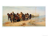
The Song of the Volga Boatmen is a traditional Russian folk song sung by the burlaks, or barge haulers, who needed to work in rhythm to pull the loaded barges along the river.
The wetlands formed where the Volga flows into the Caspian Sea is the fishing grounds for beluga sturgeon, the source of beluga caviar . .
|
|
|
|
The Volta River in western Africa is formed by three rivers known as the Black, White and Red Voltas, rising in Burkina Faso and draining through Ghana into the Gulf of Guinea.
The largest man-made lake in the world, Lake Volta in eastern Ghana, was created by damming the Volta River at Akosombo. The electrical power generated by the dam is used in the smelting of aluminum
|
|
|
|
previous page | top | next
rivers | a-b | c | d | e-f-g-h-i-j | k-l | m | n | o | p | q-r | s | T-U-V | w-x-y-z
|
|
I have searched the web for visual, text, and manipulative curriculum support materials - teaching posters, art prints, maps, charts, calendars, books and educational toys featuring famous people, places and events - to help teachers optimize their valuable time and budget.
Browsing the subject areas at NetPosterWorks.com is a learning experience where educators can plan context rich environments while comparing prices, special discounts, framing options and shipping from educational resources.
Thank you for starting your search for inspirational, motivational, and educational posters and learning materials at NetPosterWorks.com. If you need help please contact us.
|
|
|