GEOGRAPHY INDEX
................

Africa
Antarctica
Asia
Australia
Caribbean/West Indies
Central America
Cities
Europe
Explorers
Geographers
Landforms -
bays, gulfs, headlands
biomes
continents
deserts
Earth from Space
islands
isthmus & straits
lakes
mesa, plateau, butte
monolith
mountains
oceans & seas
river & stream
volcanoes
wetlands
Maps
Middle East
National Parks
North America
South America


CALENDARS

Waterfalls Calendars


Paintings of the Hudson River Calendar
Paintings of the Hudson River School Calendars


RIVERS & WATER BOOKS

Rivers and Streams
Rivers & Streams


Rivers and Lakes
Rivers & Lakes


Rivers and Oceans
Rivers & Oceans


Don't Know Much About Geography: Everything You Need to Know About the World but Never Asked
Don't Know Much About Geography...


Teacher's Best - The Creative Process


Great Rivers of the World “O...-”
for social studies and science educators and home schoolers.


geography > landforms > rivers | a-b | c | d | e-f-g-h-i-j | k-l | m | n | O | p | q-r | s | t-u-v | w-x-y-z < social studies


Rivers of the World ~

Ob
Oder

Ohio
Oise

Okavango
Orinoco


Snowy and Hazy Central Russia Showing the Ob River, Poster

(66º22'02"N 71º23'41"E)

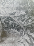
The Ob, a major river in western Siberia, Russia, is the world's fourth longest river. It is the westernmost of the three great Siberian rivers (Lena and Yenisei) that flow into the Arctic Ocean. The Gulf of Ob is the world's longest estuary.


Sunrise over the wetland in the Oder River marsh, Photographic Print
Sunrise over the wetland
in the Oder River Marsh,
Photographic Print

(53º40'19"N 14º31'25"E)

The Oder River of central Europe rises in the Czech Republic, flows through central Poland forming a border with Germany and Poland, finally flowing into the Gulf of Pomerania of the Baltic Sea.


Allegheny and Monongahela Rivers Meet to Become the Ohio River, Photographic Print
Allegheny and Monongahela Rivers Meet to Become the Ohio River,
Photographic Print

(36º59'12"N 89º07'50"W)

The Ohio River, formed by the Allegheny and Monongahela Rivers where the city of Pittsburgh was founded, is the largest tributary of the Mississippi. The Ohio serves the southern border of Ohio, Indiana, and Illinois, joining the Mississippi at Cairo, IL. The city of Cincinnati, Ohio is located on the northside of the Ohio, across from Louisville, Kentucky.

Numerous Native American groups built earthwork mounds in the Ohio Valley, de La Salle was the first European explorer in 1669, and it became a water highway for westward expansion.

Thomas Jefferson said “The Ohio is the most beautiful river on earth. Its current gentle, waters clear, and bosom smooth and unbroken by rocks and rapids, a single instance only excepted,” in fact the name Ohio is from the Seneca, meaning “good river”.

Ohio River Valley Poster Map


Bank of the Oise at Auvers, c.1890, Art Print, Vincent van Gogh
Bank of the Oise at Auvers,
c. 1890, Art Print
Vincent van Gogh

(49º23'0"N 2º25'0"E)

Oise River, a tributary of the Seine River, has been the subject of artists such as Vincent van Gogh, Charles-Francois Daubigny, Camille Pissarro, Theodore Rousseau, Paul Cezanne, and Jean-Baptiste-Camille Corot.


Aerial View of Inland Sea Formed by Okavango Delta, Botswana
Aerial View of Inland Sea Formed by Okavango Delta, Botswana, Photographic Print

(18º57'43"S 22º29'04"E)

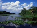
The Okavango River in Botswana has no outlet to the sea, it empties onto the sands of the Kalahari Desert where it forms the world's largest inland delta.

The swamp was once part of an ancient lake that dried up some 10,000 years ago, today it is home to wildlife and attracts thousands of visitors a year.


Orinoco Delta Landscape, Delta Amacuro, Venezuela, Photographic Print
Orinoco Delta Landscape, Venezuela, Photographic Print

(8º37'0"N 62º15'0"W)

The Orinoco, one of the longest rivers in South America, watershed covers Colombia and Venezuela. Christopher Columbus discovered the mouth of the Orinoco on his third voyage (1498), the upper reaches weren't explored until 1951.

Aime Bonpland (1773-1858), a French army surgeon, explorer, botantist and professor of natural history who collected and classified plants in the Amazon and Orinoco River basins.


previous page | top | next
rivers | a-b | c | d | e-f-g-h-i-j | k-l | m | n | O | p | q-r | s | t-u-v | w-x-y-z


I have searched the web for visual, text, and manipulative curriculum support materials - teaching posters, art prints, maps, charts, calendars, books and educational toys featuring famous people, places and events - to help teachers optimize their valuable time and budget.

Browsing the subject areas at NetPosterWorks.com is a learning experience where educators can plan context rich environments while comparing prices, special discounts, framing options and shipping from educational resources.

Thank you for starting your search for inspirational, motivational, and educational posters and learning materials at NetPosterWorks.com. If you need help please contact us.


NPW home | Global PathMarker Collection | APWTW Blog | faqs-about | contact | search | privacy
links for learning & curriculum ideas | bookshelves | toybox | media | ecards | quotes

NetPosterWorks.com ©2007-2015 The Creative Process, LLC All Rights Reserved.

last updated 12/27/13