GEOGRAPHY INDEX
................

Africa
Antarctica
Asia
Australia
Caribbean/West Indies
Central America
Cities
Europe
Explorers
Geographers
Landforms -
bays, gulfs, headlands
biomes
continents
deserts
Earth from Space
islands
isthmus & straits
lakes
mesa, plateau, butte
monolith
mountains
oceans & seas
river & stream
volcanoes
wetlands
Maps
Middle East
National Parks
North America
South America


CALENDARS

Waterfalls Calendars


Paintings of the Hudson River Calendar
Paintings of the Hudson River School Calendars


RIVERS & WATER BOOKS

Rivers and Streams
Rivers & Streams


Rivers and Lakes
Rivers & Lakes


Rivers and Oceans
Rivers & Oceans


Teacher's Best - The Creative Process


Great Rivers of the World “P...-”
for social studies and science educators and home schoolers.


geography > landforms > rivers | a-b | c | d | e-f-g-h-i-j | k-l | m | n | o | P | q-r | s | t-u-v | w-z-y-z < social studies


Rivers of the World ~

Parana - Rio de la Plata
Pearl River

Platte
Po

Potomac


Rio de la Plata, Colonia Del Sacramento, Uruguay, Photographic Print

(35º40'0"S 55º47'0"W)

Paraná - Rio de la Plata

The Paraná River runs through South America (Brazil, Paraguay and Argentina) for over 3,000 miles. The Paraná merges with the Paraguay and Uruguay Rivers to form the Rio de la Plata that empties into the Atlantic Ocean. Its watershed area includes São Paulo, Buenos Aires, Asunción and Brasília.

FYI ~ The Iguazu Falls are also part of the Parana system.
~ Sebastian Cabot explored the Rio de la Plata in 1525.


The River of Pearls in Canton, China, Photographic Print

(22º46'0"N 113º38'0"E)

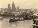
The Pearl River is an extensive river system in southeastern China that share a common delta, the Pearl River Delta. The mouth of the Pearl River forms the Zhujiang Kou bay in the delta separating Macau and Zhuhai from Hong Kong and Shenzhen.

The Pearl River gained its name for the pearl coloured shells that lie at the bottom of the river where it flows through the city of Guangzhou (Canton). Today the Pearl River is considered one of the world's most polluted waterway.


Sandhill Cranes Roost Along the Platte River in Nebraska, Photographic Print

(41º03'14"N 95º52'53"W)

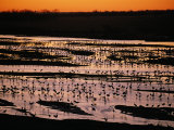
The Platte is an important river that drains a large portion of the central Great Plains in Nebraska and the eastern Rocky Mountains in Colorado and Wyoming.

The Platte is in the middle of the Central Flyway which is a primary North-South Corridor for migratory birds. It also provided a route for several major westward trails such as the Oregon Trail and the Mormon Trail.

FYI - the name Platte comes from the French word for “flat”.


View of an Old Bridge over the River Po, Turin, 1745, Giclee Print
View of an Old Bridge
over the River Po, Turin,
Giclee Print

(44º58'12"N 12º32'49"E)

The Po River, Il grande fiume or ‘great river’, is the longest river in Italy, fed by 141 tributaries draining a catchment basin of 27,000 square miles that includes the cities of Turin and Milan.

The Po flows east to west creating the Val Padana, a plain that stretches across northern Italy from the French border and Alps on the west to the Adriatic Sea on the east, just south of Venice.


Aerial View of D.C. and the Potomac River from Georgetown, Washington, D.C., Photographic Print
Aerial View of D.C. and the Potomac River from Georgetown, Washington, D.C.,
Photographic Print

(37º59'57"N 76º14'59"W)

Potomac River rises in West Virginia and flows into the Chesapeake Bay, forming the border between Maryland and Virginia.

The shores of the Potomac are rich in American history, places and events, with the U.S. national capital, Washington, DC, straddling the river.

Tidewater Poster Map


previous page | top | next
rivers | a-b | c | d | e-f-g-h-i-j | k-l | m | n | o | P | q-r | s | t-u-v | w-x-y-z


I have searched the web for visual, text, and manipulative curriculum support materials - teaching posters, art prints, maps, charts, calendars, books and educational toys featuring famous people, places and events - to help teachers optimize their valuable time and budget.

Browsing the subject areas at NetPosterWorks.com is a learning experience where educators can plan context rich environments while comparing prices, special discounts, framing options and shipping from educational resources.

Thank you for starting your search for inspirational, motivational, and educational posters and learning materials at NetPosterWorks.com. If you need help please contact us.


NPW home | Global PathMarker Collection | APWTW Blog | faqs-about | contact | search | privacy
links for learning & curriculum ideas | bookshelves | toybox | media | ecards | quotes

NetPosterWorks.com ©2007-2015 The Creative Process, LLC All Rights Reserved.

last updated 7/31/13