|
|
|
|
|
|
|
|
|
|
|
|
BOOKS ABOUT FRANCE & FRENCH CULTURE
|
|
|
|
|
|
|
|
|
|
|
|
|
|
|
|
|
|
|
|
|
|
|
|
|
|
|
 |
|
|
|
|
|
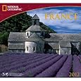
France & French Culture Educational Posters & Prints, pg 1/2
curriculum resources for classrooms and home schoolers.
|
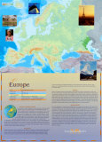
geography > Europe > FRANCE & FRENCH CULTURE pg 1 | pg 2 < social studies
|
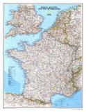
France, a part of the European Union, is a ‘unitary semi-presidental republic’ located in Western Europe and has several overseas islands, territories, and collectivities: French Guiana, French Polynesia, Guadeloupe, Martinique, Mayotte, New Caledonia, Reunion, St Barthelemy, St Martin, Saint Pierre and Miquelon Isl, and Wallis and Fortuna Isl.
The part of France located on the mainland of the European continent (and including the Mediterrean Island of Corsica) is called Metropolitan France, a designation that originated during the 16th century colonial period. The word “metropolitan” is from the Greek: meter=mother+polis=town.
Metropolitan France is often called L’Hexagone (“The Hexagon”) because of the geometric shape of its territory that extends from the Mediterranean Sea on the south to the English Channel and the North Sea, and from the Rhine River on the east to the Atlantic Ocean on the west. The countries bordering France are Spain and Andorra to the south, with Belgium, Luxembourg, Germany, Switzerland, Italy, and Monaco.
Its main ideals are expressed in the Declaration of the Rights of Man and of the Citizen.
|
|
|
|
To Julius Caesar, Gaul was a potential breadbasket that could also buffer Rome's borders from attacking Germanic tribes. Although the Celts who inhabited Gaul outnumberd the Roman invaders, disunity and dissension led to a series of defeats starting in 58 B.C. A young Celtic warrior, Vercingetorix, valiantly rallied a unified army to repel Caesar's legions, but after small victories his troops were besieged in a hilltop fortress in Alesia in 52 B.C. Vercigetorix surrendered and was paraded throught the streets of Rome. Five centuries of Roman rule brought the more primitive Celts a legal system, taxes, wine making, Christianity, and the Latin language. Barbarians ended Rome's rule in A.D. 476.
As king of the Franks from 768 to 814, Charlemagne repelled invaders and united all of present-day France except the stubborn Celts in Brittany. He extended his domain include most Christian lands in western Europe. Crowned Holy Roman Emperor by Pope Leo III in 800, Charlemagne revived Latin culture and gave Europe its governmental traditions. In 842 his grandsons carved his empire in to three parts: a Teutonic nation in the east, later called Germany; a Romanic state in the west, soon to be France; and a precarious, contested state in between.
From 987, when Hugh Capet's accession launched the Capetian dynasty, most kings were crowned at Reims. According to tradition this was the site where Clovis, king of the Franks, was baptized in 496, leading to the spread of Christianty among his people. Charles VII of the contested Valois dynasty gained legitimacy as the king also after being crowned here in 1429.
Between 1337 and 1453 England and France intermittently warred over the legitimacy of the Valois dynasty and over English control of Aquitaine and other provinces. Joan of Arc, a young peasant inspired by devine voices, turned the tide of English victorie by liberating the city of Orleans and persuading Charles VII to claim his throne. Burned as a heretic by the English, she revived France's devotion to monarchy and the loyalty of its contentious provinces.
Acquisitive Louis XIV bought or plundered most of the last few pieces to flesh out France's modern borders in the northeast. His death in 1715 left the country rich in glory but poor in pocketbook, contributing to the grievances that would spark the Revolution of 1789. In the spirit of rationalism, the revolutionary National Assembly redrew the nation into 83 departments of roughly equal size, renaming feudal regions with geographic terms to dilute old loyalties.
Bouyed by military success in Italy, Corsican general Napoleon Bonaparte seized power in 1799. He instituted an enlightened civil code and religious freedom and then, after crowning himself emperor in 1804, conquered mostof Europe. His expansionism stopped in Russia, where a shortage of food and forage forces his troop's retreat in the midst of winter. A brief comback after exile to Elba ended at Waterloo in 1815.
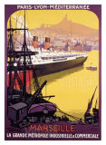
Insurrections in 1830, 1848,1851, and 1871–aftershocks of the 1789 Revolution– rocked France. The nation had lurched from an absolute monarchy to a republic, passing through a constitutional monarchy, a shaky republic, and an empire along the way. A revolution in industry spawned both a rebellious workers movement and a strong middle class. Meanwhile France was rapidy acquiring an empire in Africa, starting with Algerian 1830, as well as in Indochina, the South Pacific, and, by the close of World War I, the Near East. The old royal empire–colonies in North America, the Caribbean, and India–had been largely lost or sold by the 1800s.
In the 1860s artist Edouard Manet broke the rich tradition of realism, in which French painters had excelled for centuries, by concentrationg on technique and design over subject matter. The luminosity of his brushwork inspired the Impressionists, but he refused to exhibit at their unfashionable shows.
Arts and sciences flourished in France during La Belle Epoque. Gustave Eiffel designed his lattice wrought-iron tower for and 1886 competition. Louis Pasteur invented the pasteurization process and a rabies vaccine. Marie Curie earned Nobel Pries in physics and chemistry for her work with radium and polonium, radioactive elements. Novelist Marcel Proust experimentd with a probing stream-of-consciousness technique.
Victory in World War I returned to France the region of Alsace-Lorraine, most of which Bismarck had pried away in 1870. The price was stiff. The war cost France half of its industry and 10 percent of its men. Georges Clemenceau had rallied his country against the last, and toughest, German attacks. In negotiation the Treaty of Versailles, he insisted Germany pay onerous reparation. “Peace,” he said, “is only war pursued by other means.”
After quick surrender to Germany in 1940, France's collaborationist government moved to Vichy in the unoccupied zone, while Gen. Charles de Gaulle formed a Free French government when Hitler attacked Russia in 1941. Allied victory restored France's prewar boundaries; Italy ceded tiny areas for war damages.
|
|
|
|
|
|
|
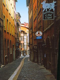
Paris, the capital city of France, was first settled by a Gallic tribe known as the Parisii, on an island in the Seine River, sometime aroung 250 BC.
|
|
|
|
|
Paris is known as the “City of Light”. As a world art and history center, the city is a popular tourist destination with many iconic landmarks such as the Eiffel Tower, designed by Gustave Eiffel for the 1889 Universal Exposition in Paris.
• world tree
|
|
|
|
|
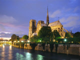
Notre Dame de Paris cathedral is widely considered one of the finest examples of Gothic architecture which flourished in Europe during the high and late medieval period. Gothic is characterized by the light let in by stained glass windows that were possible because of the new building techniques of the pointed arch, ribbed vault and flying buttress.
Notre Dame translates as “Our Lady” from French.
• architecture posters
• Christianity posters
• river posters
|
|
|
|
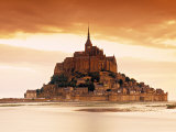
According to legend in 708, St. Michael the Archangel appeared to St. Aubert, bishop of Avranches, instructing him to build a church on the rocky islet just off the coast of Normandy.
It is depicted in the Bayeux Tapestry which commemorates the 1066 Norman conquest of England.
|
|
|
|
|
|
|
|
|
pg 2 France posters | previous page | top
| Picturing France 1830-1900 Lesson Plan |
|
|
I have searched the web for visual, text, and manipulative curriculum support materials - teaching posters, art prints, maps, charts, calendars, books and educational toys featuring famous people, places and events - to help teachers optimize their valuable time and budget.
Browsing the subject areas at NetPosterWorks.com is a learning experience where educators can plan context rich environments while comparing prices, special discounts, framing options and shipping from educational resources.
Thank you for starting your search for inspirational, motivational, and educational posters and learning materials at NetPosterWorks.com. If you need help please contact us.
|
|
|