|
|
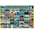
Landforms Geography Posters, Art Print, & Charts Index
for geography and social studies classrooms, home schools.
|
world geography > LANDFORMS < social studies
|
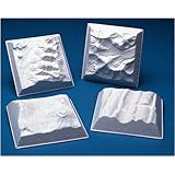
LANDFORMS are topographical (topos = place + graphy = to write) characteristics of the surface of the Earth (and other planets) that have evolved through plate tectonics (earthquakes), volcanoes, erosion due to wind, water, and glaciers.
Terrain describes the vertical dimension (elevation and slope) of topography.
Continents, large continuous landmasses, are the largest landforms. Oceans are the largest water bodies.
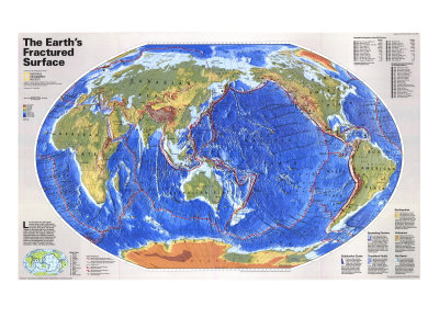
Like the pieces of a giant jigsaw puzzle, slabs of rocky crust known as tectonic plates fit together to form the Earth's outer shell. The puzzle changes as the plates slide over the hotter, softer rocks beneath them. Moving by mere inches annually, they reshape continents and ocean basins over millions of years by colliding, separating, and scraping past one another with relentless force. These interactions set off earthquakes, fire up volcanoes, wrinkle the earth's crust into mountains, valleys, and deep-sea trenches. ... more text
|
|
|
|
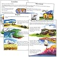
Landforms: A feature of the Earth's surface, such as plains, plateaus, mountains, dunes, seas, swamps, etc. Oceans and continents can be considered the highest order of landforms.
Ocean: The entire body of salt water that covers 70% of the Earth's surface, or any separate parts of the ocean, including the Arctic, Atlantic, Pacific, Indian, and Southern Oceans.
Continent: A large continuous landmass above sea level. The Earth's surface can be divided into seven continents: Africa, Antarctica, Asia, Australia, Europe, North America, and South America.
• Oceans & Seas
• Continents
|
|
|
|
Bay: A body of water partially surrounded by land, with an outlet to a larger body of water such as a gulf or sea. The Hudson Bay is an example.
Gulf: Apart of an ocean or sea extending into the land. A gulf is similar to a bay, but is usually larger and extends farther inland. The Gulf of Mexico is an example.
Sea: A large body of salt water that is partly or completely surrounded by land. A sea usually forms part of, or connets with, an ocean. The Mediterranean Sea is an example.
Sound: A ... of the sea or ocean, usually parallel to the coastline. A sound often separates the mainland and an island. May also be called a strait or channel.
Cove: A small inlet or recess in the shoreline of a larger body of water, such as a sea, lake, or river. A cove is smaller than a bay.
Canal: A man-made or artificial channel constructed to connect two bodies of water.
Harbor or Harbour: A body of water nearly surrounded by land, sea walls, breakwaters or artificial walls, forming a safe anchorage for ships.
• bays, gulfs, headlands
|
|
|
|
Canyon: A deep narrow valley with exceptionally steep side, usually carved by a fast-flowing river that may or may not still be in evidence. Sometimes also referred to as a gorge.
Cliff: A very steep or vertical slope of rock. On a topographic map, a cliff is indicated by contour lines place very close together or merging into a singel line. The closer the contour lines are to each other, the steeper the slope.
Cave: A naturally formed opening beneath the Earth's surface that is large enough for a hua to enter and has an area tha is in perpetual darkness.
|
|
|
|
Glacier: A large, slow-moving river of ice formed by multi-year snow accumulating on sloping terrain. Glaciers move very gradually downslope or outward, carving out valleys along the way. The runoff water creates rivers that further erode the landscape.
Iceberg: A large floating chunk of ice, usually broken off from a glacier and carried out to sea on ocean currents, Typically, around 90% of the volume of an iceberg is under water, so the visible ice above the furface doesn't reveal much about the size and shape of the whole thing this has led to the expression “tip of the iceberg.”
Fjord: A deep, steep-walled inlet of the sea formed by a glacier. May also be known as an inlet or sound.
|
|
|
|
Island: Any piece of land, smaller than a continent and largerthan a rock, which is completely surrounded by water. Very small islands are called islets. Groups of related islands are called archipelagos.
Peninsula: A narrow extension of land surrounded on three sides by water, but connected to a larger land mass. Usually more extensive than a cape.
Cape: A point or head of land projecting beyond the ajacent coast into a body of water.
Atoll: A ring of coral islands or reefs usually surrounding an interior body of water called a lagoon. Atolls often mark the location of submerged mountain ranges or extinct volcanic islands.
• Islands of the World posters
|
|
|
|
Lake: A large body of water, entirely or nearly surrounded by land. Lakes can be naturally occurring or man-made, and are usually fresh water. They are often fed by streams or rivers, although some were formed by glaciers.
Pond: A still body of water, smaller than a lake, often shallow enough for rooted plants to grow throughout. Ponds are often fed by a small stream.
Marsh: An area of soft, wet, or periodically submerged land, usually a transition zone between land and water (wetland). Marshes are generally timeless and usually feature grasses and other low vegetation.
Swamp: A low-lying wetland saturated with water throughout much or all of the year. Similar to a marsh but with more woody plants and trees.
• Lakes of the World posters
|
|
|
|
Mountain: A naturally raised part of Earth's surface. Some mountains look jagged and sharp at the top while others appear more rounded. A mountain is generally much highter and steeper than a hill.
Hill: A natural elevation of the Earth's sruface, rising rather prominently above the surrounding land, usually ofl imite extent and having a well defined outlne (sounded rather than peaked or rugged). Generally considered to be less than 300 meters from base to summit.
Valley: A broad area of low-lying land situated between hills or mountains, often with a river or stream running through it.
• Mountains of the World posters
|
|
|
|
Plain: A large, low-lying area of land with relatively minor elevation changes. A plain is formed by deposition or erosion of soil over a long period of time.
Plateau: A broad, flat-topped, steep-sided area elevated above the land surrounding it. Plateaus, like mesas and buttes, are formed when land has been pushed upward and then eroded by wind or water.
Mesa: An elevated area of land with a flat top and steep sides that often form cliffs. A mesa is similar to a plateau, but less extenive, and similar to but larger than a butte.
Butte: An isolated hill with very steep sides and a small flat top. Buttes are formed when wind and/or water erosion causes mesas to slowly, shrink in size.
|
|
|
|
River: A large, flowing body of water that, usually empties into a larger body of water.
Basin: The entire geographical are drained by a river and its tributaries. (watershed)
Delta: A fan-shaped area formed by deposits of sediment where a river enters a larger body of water such as a sea, fulf or bay.
Estuary: A thin zone along a coastline where freshwater systems such as rivers and streams meet, and mix with bays, gulfs or other bodies of salt water.
• Rivers of the World posters
|
|
|
|
Volcano: An opening in the Earth's crust through which lava, ash, and gases erupt, forming a cone-shaped structure as colled layers build up over time.
Geyser: A hot spring that erupts periodically, sending jets of water and/or steam into the air.
Hot Spring: Water warmed by geothermal energy that seeps to the Earth's surface to form a small pond.
Cinder Cone: A small volcanic cone built of ash and cinders.
• Volcanoes of the World posters
|
|
|
|
|
|
|
|
|
previous page | top
|
|
I have searched the web for visual, text, and manipulative curriculum support materials - teaching posters, art prints, maps, charts, calendars, books and educational toys featuring famous people, places and events - to help teachers optimize their valuable time and budget.
Browsing the subject areas at NetPosterWorks.com is a learning experience where educators can plan context rich environments while comparing prices, special discounts, framing options and shipping from educational resources.
Thank you for starting your search for inspirational, motivational, and educational posters and learning materials at NetPosterWorks.com. If you need help please contact us.
|
|
|