GEOGRAPHY

Africa
Algeria
Angola
Benin
Botswana
Burkina Faso
Burundi
Cameroon
Cape Verdi
Central African Rep
Chad
Comoros
Congo
Cote d'Ivoire
Djibouti
Egypt
Equatorial Guinea
Eritrea
Ethiopia
Gabon
Gambia
Ghana
Guinea
Guinea-Bissaau
Kenya
Lesotho
Liberia
Libya
Madagascar
Malawi
Mali
Mauritania
Mauritius
Morocco
Mozambique
Namibia
Niger
Nigeria
Reunion
Rwanda
Sao Tome
& Principe
Senegal
Seychelles
Sierra Leone
Somalia
South Africa
Sudan
Swaziland
Tanzania
Togo
Tunisia
Uganda
Western Sahara
Zambia
Zimbabwe
Antarctica
Asia
Australia
Caribbean/West Indies
Central America
Cities
Europe
Explorers
Geographers
Landforms
Maps
Middle East
National Parks
North America
South America


AFRICA
CALENDARS

Women of the African Ark Calendars
Women of the
African Ark
Calendars


Africa Calendars
Africa Calendars


BOOKS ABOUT ALGERIA

Algeria - Modern Nations of the World

Michelin Algeria/Tunisia Map

Sahara: A Natural History
Sahara:
A Natural History

Into Africa
Into Africa:
A Journey Through
the Ancient Empires

Africa: Biography of the Continent

Hands-On Africa
Hands-On Africa: Art Activities for All Ages...

Tales from Africa
Tales from Africa

Eyewitness Africa
Eyewitness: Africa


Teacher's Best - The Creative Process


Algeria & Algerian Culture Posters, Prints, Charts, Maps
for social studies classrooms, home schoolers, theme decor.


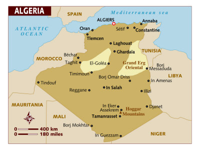
geography > Africa > ALGERIA < social studies


Algeria Map
Algeria Map

(36º42'0"N 3º13'0"E)

Algeria Flag
Algeria Flag

Africa, Its Political Development Map 1980, Giclee Print
Africa, Its Political Development Map 1980,
Giclee Print

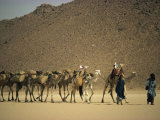
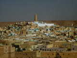
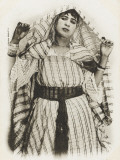
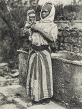
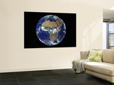
The People's Democratic Republic of Algeria is in north Africa on the Mediterranean coast. Algeria, the second largest nation on the African continent, is bordered on the northeast by Tunisia, the east by Libya, Niger on the southeast, Mali and Mauritania on the southwest and Morocco on the west. Algeria is constitutionally an Islamic, Arab and Berber nation, and included in descriptions of Middle Eastern countries.

View of the Terraced White City, Algiers from the Busy Waterfront, Photographic Print
View of the Terraced White City,
Algiers from the Busy Waterfront,
Photographic Print

(36º42'0"N 3º13'0"E)

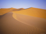
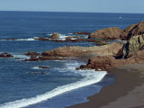
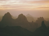
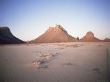
The coastline is mountainous, just inland is a fertile belt called the Tell, further south are the Atlas Mountains and then the Sahara Desert.

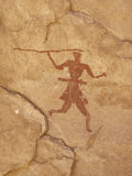
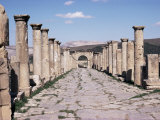
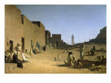
Algeria has been inhabited for millenia, first by Berbers, then ruled by the Carthaginians, Rome, the Vandals, Byzantium, Arabs, invasion attempts by Spain, the Ottoman Empire, gaining independence from the French in 1962.

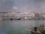
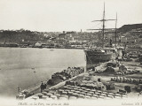
Algiers, the capital and largest city is located on the Mediterrean coast. The name is from an Arabic word which means “the islands”, for the islands that became part of the mainland in 1525.


Sand Dunes, Grand Erg Occidental, Sahara Desert, Algeria, Africa, Photographic Print

Coastline Near Cherchell, Algeria, North Africa, Africa, Photographic Print
Coastline near Cherchell, Algeria, North Africa, Africa,
Photographic Print

Ancient Rock Art at Tassili-N-Ajjer, Photographic Print
Ancient Rock Art
at Tassili-N-Ajjer,
Photographic Print

(25º10'0"N 8º10'0"E)

Sahara Desert, Hoggar Mountains, Sunrise Over Assekrem, Algeria, North Africa, Photographic Print
Sahara Desert, Hoggar Mountains,
Sunrise Over Assekrem, Algeria, North Africa,
Photographic Print
Tidikmat Mountains, Algeria, North Africa, Africa, Photographic Print
Tuareg People Leading Camel Train across Desert, Algeria, North Africa, Africa, Photographic Print

landforms posters
desert posters
national parks posters


Main Street and Arch from the Capitol, Roman Site of Djemila, UNESCO World Heritage Site, Algeria, Photographic Print
Main Street and Arch from the Capitol, Roman Site of Djemila,
UNESCO World Heritage Site, Algeria,
Photographic Print
The Port at Oran, Algeria, Photographic Print
Cityscape Ghardaia, Algeria, Photographic Print
Laghouat in the Algerian Sahara, 1879, Giclee Print
Jewish Concert, Tiemcen, Algeria, Giclee Print
Algerian Children from the Region of Annaba, Late 19th Century, Giclee Print
Algerian Children from the Region
of Annaba, Late 19th Century,
Giclee Print


An Algerian Woman Doing the Handkerchief Dance - Algeria, Photographic Print
An Algerian Woman Doing the Handkerchief Dance - Algeria,
Photographic Print
Black African Mother and Child from Southern Algeria, Photographic Print
Black African Mother and Child
from Southern Algeria,
Photographic Print


Stomping Grapes to Make Wine on a Collective Farm in Algeria, Photographic Print
Stomping Grapes to Make Wine on a Collective Farm in Algeria,
Photographic Print
Flowering Field in Algeria, North Africa, Photographic Print
A Cake and Date Seller in Biskra, Southern Algeria, Photographic Print
A Cake and Date Seller
in Biskra, Southern Algeria,
Photographic Print
A Moorish Couscous Maker, Algeria, Photographic Print
A Moorish Couscous Maker, Algeria,
Photographic Print

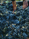
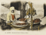
Couscous is a Berber pasta dish of semolina traditionally served with a meat or vegetable stew spooned over it. Couscous, which is among the healthiest grain-based products, is a staple food throughout Algeria, Morocco and Tunisia. Couscous is very labor-intensive to produce.


Full Earth Showing Africa, During Day, 8/7/2001, Wall Mural
Full Earth Showing Africa,
During Day, 8/7/2001,
Wall Mural

• more Earth from Satellite Posters
Black History Posters


Augustine of Hippo, Apuleius, Albert Camus, Isabelle Eberhardt


previous page | top

I have searched the web for visual, text, and manipulative curriculum support materials - teaching posters, art prints, maps, charts, calendars, books and educational toys featuring famous people, places and events - to help teachers optimize their valuable time and budget.

Browsing the subject areas at NetPosterWorks.com is a learning experience where educators can plan context rich environments while comparing prices, special discounts, framing options and shipping from educational resources.

Thank you for starting your search for inspirational, motivational, and educational posters and learning materials at NetPosterWorks.com. If you need help please contact us.


NPW home | Global PathMarker Collection | APWTW Blog | faqs-about | contact | search | privacy
links for learning & curriculum ideas | bookshelves | toybox | media | ecards | quotes

NetPosterWorks.com ©2007-2015 The Creative Process, LLC All Rights Reserved.

last updated 12/2/13