GEOGRAPHY

Africa
Algeria
Angola
Benin
Botswana
Burkina Faso
Burundi
Cameroon
Cape Verdi
Central African Rep
Chad
Comoros
Congo
Cote d'Ivoire
Djibouti
Egypt
Equatorial Guinea
Eritrea
Ethiopia
Gabon
Gambia
Ghana
Guinea
Guinea-Bissaau
Kenya
Lesotho
Liberia
Libya
Madagascar
Malawi
Mali
Mauritania
Mauritius
Morocco
Mozambique
Namibia
Niger
Nigeria
Reunion
Rwanda
Sao Tome
& Principe
Senegal
Seychelles
Sierra Leone
Somalia
South Africa
Sudan
Swaziland
Tanzania
Togo
Tunisia
Uganda
Western Sahara
Zambia
Zimbabwe
Antarctica
Asia
Australia
Caribbean/West Indies
Central America
Cities
Europe
Explorers
Geographers
Landforms
Maps
Middle East
National Parks
North America
South America


AFRICA
CALENDARS

Women of the African Ark Calendars
Women of the
African Ark
Calendars


Africa Calendars
Africa Calendars


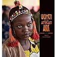
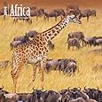
BOOKS ABOUT AFRICA & LIBYA

Libya Map
Libya Map

Libya: The Lost Cities of the Roman Empire
Libya:
The Lost Cities
of the Roman Empire

Sahara: A Natural History
Sahara:
A Natural History

Into Africa
Into Africa:
A Journey Through
the Ancient Empires

Dark Star Safari
Dark Star Safari: Overland from Cairo to Cape Town

Africa: Biography of the Continent

Hands-On Africa
Hands-On Africa: Art Activities for All Ages...

Tales from Africa
Tales from Africa


Eyewitness Africa
Eyewitness: Africa


Teacher's Best - The Creative Process


Libya Posters, Prints, Charts, & Maps
for social studies classrooms, homeschoolers and scholars.


geography > Africa > LIBYA < Middle East < social studies


Libya Maps
Libya Map

(27º24'0"N 17º36'0"E)

Libyan National Flag


Africa, Its Political Development Map 1980, Giclee Print
Africa, Its Political Development Map 1980,
Giclee Print

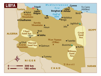
Libya, the fourth largest country in Africa, and the 17th largest in the world, is on the northern Mediterranean Sea coast between Egypt to the east, Sudan on the southeast, Chad on the south, Niger on southwest, and Tunisia and Algeria on the west.

The word Libya is Greek from the Egyptian word “Lebu” which referred to the Berber nomadic tribes who lived west of the Nile River. The three traditional parts of Libya are Tripolitania in the northwest, Fezzan in the south, and Cyrenaica in the northeast.

Libya is considered part of Maghreb, an Arabic word meaning “place of sunset”, and describing the western areas of their world. The Europeans called the Maghreb the Barbary Coast from the 16th to the 19th century, a name taken from the word Berber.

Dust Blows Off the Coast of Libya Heading over the Mediterranean Sea, Photographic Print
Dust Blows Off the Coast
of Libya Heading over the Mediterranean Sea,
Photographic Print

Phoenicians, Carthaginians, Greeks, Romans, Vandals and Byzantines all ruled at one time, the Arabs took over in the 6th Century AD, the name Libya was given to the country in 1934 by the Italian invaders.

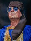
Libya was the first country to achieve independence (as a constitutional monarachy) through the United Nations, but in 1969 coup over King Idris I put Col. Muammar Abu Minyar al-Qadhafi, in place. Qadhafi's rule ended in revolution during the summer of 2011.

In September of 2012 the American diplomatic mission at Benghazi was attacked by a heavily armed group, resulting in the deaths of US Ambassador J. Christopher Stevens and three others.


A Sand Dune Rises Out of the Sahara Desert, Ghadhames, Libya, Giclee Print

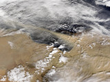
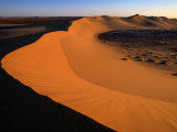
The Libyan Desert, a part of the Sahara, covers most of Libya. The northern coastline has a milder Mediterranean climate.

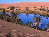
Ghadhames is in western Libya, very near the borders of Tunisia and Algeria.


Umm Al-Miah- One of the Oasis Pools Part of the Dawada Lakes, Awbari, Libya, Photographic Print

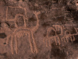
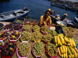
The Dawada are an ethnic group in the southern Fezzan region of Libya. They harvest brine shrimp from the salty lakes and sell them to caravans. The name Dawada means “worm-folk” in Arabic.

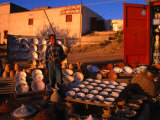
The nomadic Tuareg people, probably descended from ancient Saharan peoples described by Herodotus, are in southern Libya.


Souk, Tripoli, Tripolitania, Libya, North Africa, Africa, Photographic Print
Souk, Tripoli, Tripolitania, Libya,
North Africa, Africa,
Photographic Print

(32º54'8"N 13º11'9"E)

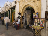
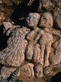
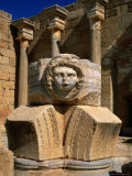
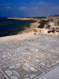
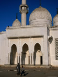
Tripoli, located on the Mediterranean coast, is the largest city and capital of Libya.

The city was founded in the 7th century BC by Phoenicians, calling it Oea, who were probably attracted to the natural harbor and easily defended peninsula.

The name “Tripoli”, bestowed by the Romans, is from the Greek and means “three cities” (tri=three, poli=city), and includes reference to the nearby towns of Sabratha and Leptis Magna.


Prehistoric Rock Paintings Depicting Life 10,000 Years Ago, Libya, Giclee Print

mountain posters

Ancient Rock Carvings of People and Animals at Slonta, Al Jabal Al Akhdar, Libya, Giclee Print
Ancient Rock Carvings
of People and Animals at Slonta,
Al Jabal Al Akhdar, Libya,
Giclee Print


Settled during the first millennium BC, Leptis Magna was originally a Phoenician port, Libya, Giclee Print

architecture posters

The Wonderfully Intact Byzantine Mosaics of the Roman Baths at Sabratha, Sabratha, Libya, Giclee Print
The Wonderfully Intact Byzantine Mosaics of the Roman Baths
at Sabratha, Sabratha, Libya,
Giclee Print

Roman culture posters

Umm Al-Miah- One of the Oasis Pools Part of the Dawada Lakes, Awbari, Libya, Photographic Print
The Mosque of Al Bayda, Al Bayda, Libya, Giclee Print

The Mosque of Al Bayda, Al Bayda, Libya

Islam posters


Vendor Selling Fruit at the Fish Market, Tripoli, Tarabulus, Libya, Giclee Print
Vendor Selling Fruit at the Fish Market, Tripoli, Tarabulus, Libya,
Giclee Print

food posters

Boy Selling Ceramic Pottery from Roadside Stall, Tripoli, Libya, Giclee Print
Boy Selling Ceramic Pottery
from Roadside Stall, Tripoli, Libya,
Giclee Print


King Idris I, Art Poster by National Archive
King Idris I, Art Poster
National Archive

Painting of Libyan Leader Colonel Muammar Al-Gaddafi, Tripoli, Tarabulus, Libya, Giclee Print


Burning of the American Ship, Philadelphia, Held by Barbary Pirates in Tripoli Harbor, c.1804, Poster
Burning of the American Ship, Philadelphia, Held by Barbary Pirates in Tripoli Harbor, 2-16-1804, Poster

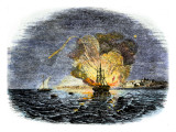
In 1804 the young United States fought with the Barbary Corsairs to stop the piracy of American ships and the enslavement of sailors, such as the USS Philadelphia.

On the night of February 16, 1804, Lieutenant Stephen Decatur led a small contingent of U.S. Marines to storm the captured USS Philadelphia vessel and overpowered the Tripoli sailors standing guard. With support from American ships, the Marines set fire to Philadelphia, denying her use to the enemy.


previous page | top

I have searched the web for visual, text, and manipulative curriculum support materials - teaching posters, art prints, maps, charts, calendars, books and educational toys featuring famous people, places and events - to help teachers optimize their valuable time and budget.

Browsing the subject areas at NetPosterWorks.com is a learning experience where educators can plan context rich environments while comparing prices, special discounts, framing options and shipping from educational resources.

Thank you for starting your search for inspirational, motivational, and educational posters and learning materials at NetPosterWorks.com. If you need help please contact us.


NPW home | Global PathMarker Collection | APWTW Blog | faqs-about | contact | search | privacy
links for learning & curriculum ideas | bookshelves | toybox | media | ecards | quotes

NetPosterWorks.com ©2007-2015 The Creative Process, LLC All Rights Reserved.

last updated 12/27/13