|
|
Mountains & Mountain Ranges Posters & Art Prints
for social studies and geography educators, and home schoolers.
|
social studies > geography > MOUNTAINS POSTERS 1 | 2 | volcanoes | Seven Summits < geology < science
|
|
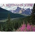
Mountains are land masses that project well above the surroundings.
Mountains are formed by volcanic activity where -
- molten rock either erupts through the surface as lava or pushs up and cools beneath the surface as domes,
- as rocks push against each other either creating “folds” or faults,
- or as wind and rain wear away softer rock and leave hard rock formations.
• “I have found a dream of beauty at which one might look all one's life and sigh.” ~ Isabella Bird Bishop, Adventures in the Rocky Mountains
• “Creative people who can't help but explore other mental territories are at greater risk, just as someone who climbs a mountain is more at risk than someone who just walks along a village lane.” ~ R. D. Laing
|
|
|
|
|
|
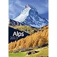
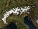
Alps Mountains
The Alps are one of the great mountain ranges of Europe, stretching from France and Germany on the west, through Liechtenstein, Switzerland, and Italy, to Solvenia and Austria on the east. Mont Blanc is the highest mountain in western Europe.
|
|
|
|
Andes Mountains is the longest mountain range in the world, stretching over 4,400 miles (7,000 km) along the western Pacific Coast of South America. The Andes are part of the Pacific Ring of Fire, the zone of frequent earthquakes and volcanic eruptions partially surrounding the Pacific Basin.
The word Andes means “high crest” and comes from "anti" in the Inca language of Quechua. Aconcagua, in the Argentinian Andes, is the highest peak outside of Asia (22,841 ft/6,962 m) and one of the Seven Summits.
|
|
|
|
The Appalachian are made up of “elongated belts of folded and thrust faulted marine sedimentary rocks, and volcanic rocks”.
Appalachian ranges include (north-south) Long, Annieopsquotch, Shickshock, Notre Dame, Longfellow, White (NH), Green (VT), Taconic (NY), Berkshire (MA), Allegheny (PA, MD, WV), Poconos (PA), Blue Ridge (Carolinas to NY).
The flora and fauna of the Appalachians vary by environmental conditions proscribed by the geology, latitude, and elevation of a particular area.
The Appalachians formed a natural western boundary to the expansion of the British colonies from the east coast of North America; both a protection for the settlers and the Native Americans from each other.
The name Appalachian appears to be connected to the name a 16th century Spanish expedition transcribed for a Native American village near a river that is known today as the Apalachicola.
FYI ~ Supreme Court Justice William O. Douglas hiked the entire Appalachian Trail from Springer Mountain, Georgia to the terminus at Mount Katahdin in Maine, approximately 2,000 miles.
|
|
|
|
The Atlas Mountains in NW Africa extend through Morocco, Algeria, and Tunisia, and include the Rock of Gibraltar and separate the Mediterranean and Atlantic coastlines from the Sahara Desert. They are generally divided into four regions, west to east: Middle, High and Anti-Atlas, the Saharan Atlas, the Tell Atlas and the Aures Mountains.
Today's Atlas and Allegheny/Appalachian ranges are thought to have first formed when the continents now known as Europe, Africa and North America collided to form the supercontinent of Pangaea, and then drifted apart.
|
|
|
|
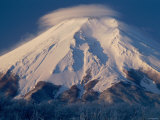
Mount Fuji, an active volcano with a low risk of eruption, is the highest point in Japan and a national symbol.
The high altitude cloud in this image is called lenticular; they are characteristized by their lens appearance and smooth saucer-like shape.
|
|
|
|
|
|
|
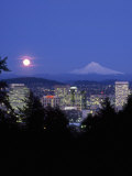
Mount Hood, a stratovolcano in the Cascade Volcanic Arc is the highest point in Oregon and the fourth-highest in the Cascade Range. The peak is a prominent landmark visible up to a hundred miles away. The United States Geological Service characterizes Mount Hood as “potentially active”.
The peak is home to twelve glaciers.
•more National Parks posters
|
|
|
|
|
|
|
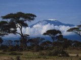
Mount Kilimanjaro, Tanzania, Africa
Kilimanjaro (Kilima Njaro - Swahili for “shining mountain”), the tallest free-standing mountain rise in the world, is a currently inactive stratovolcano. There are concerns about magma build-up and rapidly retreating glaciers near the summit.
In 1934 early film journalists Martin and Osa Johnson were the first to fly over Mount Kilimanjaro, and filmed the adventure.
Author Ernest Hemingway wrote a short story titled The Snows of Kilimanjaro , first published in 1936. , first published in 1936.
|
|
|
|
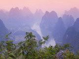
The landscape along the Li River in China is called ‘karst’, a term for a landscape shaped by the “dissolution of bedrock layer(s), resulting in distinctive surface features and underground drainages”.
Karst topography is visible in the Kras Plateau border area of Italy and Slovinia, and in southern Missouri and northern Arkansas Ozark region of the United States.
|
|
|
|
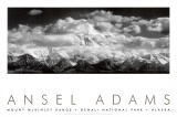
The Mt. McKinley Range or the Denali, which means “the great one”, has the highest mountain peak in North America at 20,320 feet (6,194 m). It is part of the Alaska Range, which is in the Pacific Ring of Fire.
The mountain is referred to both as Denali and McKinley after beiing renamed to honor US President William McKinley in 1897.
|
|
|
|
|
|
|
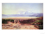
Parnassus, a limestone mountain located in central Greece, is said to be sacred to Apollo, the Corycian nymphs, and a home to the Muses, making the area renown for poetry, music, and learning.
According to Ovid, who recounted the Greek flood myth in his Metamorphoses, the ark of Ducalion came to rest on the slopes of Parnassus.
|
|
|
|
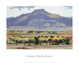
Pedernal (9,862 ft) is a flat topped butte in the Jemez Mountains of northern New Mexico.
Noted American artist Georgia O’Keeffe lived nearby and painted the peak numerous times.
The word ‘pedernal’ means ‘flint’ in Spanish, the name recognizing the local Native American's source of stone to make arrowheads, knives, spearpoints and and scrapers.
|
|
|
previous page | top | MOUNTAINS posters pg 1 | 2 | Seven Summits
|
|
I have searched the web for visual, text, and manipulative curriculum support materials - teaching posters, art prints, maps, charts, calendars, books and educational toys featuring famous people, places and events - to help teachers optimize their valuable time and budget.
Browsing the subject areas at NetPosterWorks.com is a learning experience where educators can plan context rich environments while comparing prices, special discounts, framing options and shipping from educational resources.
Thank you for starting your search for inspirational, motivational, and educational posters and learning materials at NetPosterWorks.com. If you need help please contact us.
|
|
|