|
|
Lakes of the World Posters, Prints, Charts
for social studies classrooms, home schoolers, travelers
|
social studies > geography > landforms > LAKES < water < aquatic/marine > science
|
|
Lakes are bodies of water surrounded by land.
Very large bodies of water surrounded by land are sometimes called “seas”, as in the inland Caspian and Dead Seas, which incidently have salt water.
Lakes generally are freshwater, and the majority of lakes on Earth are in the Northern Hemisphere at high latitudes. Canada has 60% of the worlds lakes and the state of Minnesota in the northern US, is known as the ‘Land of 10,000 Lakes’.
Naturally occurring lakes are either fed by rivers or streams, or the collection of water in depressions formed by glaciers, or craters in the calderas of volcanoes. The Great Salt Lake in Utah and the Dead Sea in Israel are examples of how water accumulating in a basin or depression with no outlet, evaporates and concentrates the salt levels. Man-made lakes, or reservoirs, are the result of blocking a stream with a dam (Lake Mead), or carving a depression in the ground, as in a farm pond.
Small bodies of water surrounded by land are generally described as ponds and pools, however the famous Walden Pond in Massachusetts meets all the suggested characteristic of a ‘lake’.
|
|
|
|
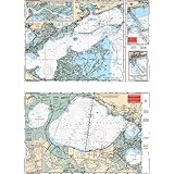
Great Lakes Basin
The Great Lakes of North America, Lakes Superior, Michigan, Huron, Erie and Ontario, originated in the Ice Age. Lake Superior is the largest freshwater lake by surface area and third largest by volume. Lake Huron and Lake Michigan form a single hydrological system.
The largest freshwater lake island is Manitoulin Isl. in Lake Huron. Lake Manitou, located on Manitoulin Island, is the largest lake on a freshwater-lake island. The largest lake on an island is Nettilling Lake on Baffin Island.
Freshwater from Lake Superior passes through the St. Marys River into Lake Huron (boat traffic bypasses the rapids with the five locks of the Soo Canals), Lake Huron into Lake Erie via the St. Clair River, Lake St. Clair, and the Detroit River, then the water flows from Erie to Ontario over the Niagara escarpment (boat traffic bypasses on the Welland Canal with eight locks), from there the St. Lawrence River leads out to sea.
GREAT LAKES DEAD ZONE - A dead zone is a colloquial term for a hypoxic zone, which is defined as an area of bottom water in a lake, estuary, or ocean where the concentration of oxygen drops below levels needed to support life. Dead zones form when nutrients — usually from fertilizer run-off or sewage treatment plants — stimulate excessive amounts of algae that sink to the bottom and decay, using up bottom-layer oxygen because it cannot get replenished from the atmosphere. Specific areas of Great Lakes that are critcal - Green Bay, Saginaw Bay, and the central basin of Lake Erie. The Gulf of Mexico and Chesapeake Bay are also showing increased dead zones.
Notable explorers of the Great Lakes region include Robert de la Salle, Father Louis Hennepin, Louis Joliet, Jean Nicolet, and Pere Marquette.
The largest cities
• Michigan posters
• Great Lakes States Poster Map
FYI - The Erie Canal is a man made river in New York State from the Hudson River at Albany to Buffalo on Lake Erie.
• more Earth from Space posters
|
|
|
|
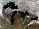
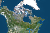
60% of the world's freshwater lakes are in Canada. This satellite photograph of Canada shows the Saint Lawrence River draining the Great Lakes into the Atlantic Ocean at the Gulf of Saint Lawrence.
|
|
|
|
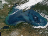
The Caspian Sea is the largest lake in the world by surface area. The Romans called it a sea because it was salty.
The Volga River drains into the Caspian Sea, forming a delta that is the fishing ground for beluga sturgeon, the source of beluga caviar.
The Black Sea is actually a distant arm of the Atlantic Ocean through the Mediterrean Sea and the Bosporus, the strait between European and the Asian parts of Turkey. The land area, an isthmus, between the Black and Caspian Seas, is the site of Mount Elbrus of the Caucacus Mountains.
The Black Sea resort of Yalta was the site of the Yalta Conference, and the port city of Odessa's great stone staircase, now popularly known as the “Potemkin Steps”, the setting of one of the most famous scenes in motion picture history.
|
|
|
|
Russia's Lake Baikal, the world's largest freshwater lake by volume (it contains 20% of the world's fresh surface water, as much as the N.A. Great Lakes combined), and the world's oldest lake, is a World Heritage Site.
Baikal is an example of a “rift” lake, a place where tectonic activity created the depression that allowed water accumulated.
Lake Tanganyika in Africa is also a rift lake. It is thought rift lakes can eventually evolve into oceans and that the Red Sea, an inlet of the Indian Ocean, began as a rift lake.
|
|
|
|
|
|
|
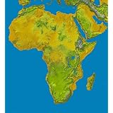
The Great Lakes of Africa - Tanganyika, Victoria, Albert, Edward, Kivu, and Malawi
are a series of lakes in and around the Great Rift Valley in eastern Africa.
Lake Tanganyika is considered the second oldest lake in the world and also the second largest in terms of volume and depth (after Lake Baikal).
Lake Victoria, the source of the White Nile River, is the second largest freshwater lake by surface area (after Lake Superior in the Great Lakes of North America).
• more Earth from Satellite Posters
|
|
|
|
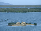
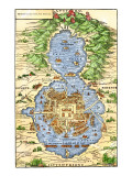
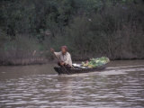
Lake Texcoco (Spanish: Lago de Texcoco) was a shallow natural lake in the Valley of Mexico where the Aztecs built their capital city of Tenochtitlan on a small island surrounded by “floating gardens” or artificial islands (chinampas) made of soil piled on reed mats anchored to the shallow lake bed.
|
|
|
|
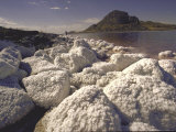
Salt lakes are bodies of water that have water flowing in but do not have an outflow. Water evaporation causes a high concentration of salts. A salt lake an excellent place for salt production, and high salinity will also lead to a unique flora and fauna in the lake.
The nearby Bonneville Salt Flats are the results of the ancient Lake Bonneville.
The Don Juan Pond in Antarctica has such a high salinity that it does not freeze; and crater lake Lac Assal in Djibouti has the world's largest salt reserves.
|
|
|
|
Louisiana's Lake Pontchartrain is an example of an estuary - a semi enclosed coastal body of water where fresh and salt water mix.
Lake Pontchartrain, the second largest salt water lake in the United States (after Utah's Great Salt Lake) is fed fresh water by five rivers, the salt water enters with the tides from the Gulf of Mexico. The city of New Orleans is on the south shore of Lake Pontchartrain.
Lake Maracaibo in Venezuela is another example of an estuary, however it is really a bay.
• Mississippi Delta poster
• Hurricane posters
|
|
|
|
|
|
|
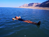
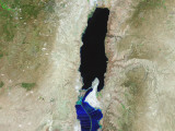
The Dead Sea, on the border between the West Bank, Israel, and Jordan, is the lowest point on Earth (1,371 ft).
Fish cannot live in the Dead Sea due to the high salinity of the water caused by the waters of the Jordan River flowing into the lake and there being no outlet.
The Dead Sea is also a rift lake, part of the Great Rift Valley that stretches form Turkey to southern Africa. The oldest continually occupied town in the world, Jericho, is just north of the Dead Sea.
• Middle East posters
|
|
|
|
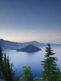
Crater lakes are the accumulation of water within the caldera of a volcano.
Notable crater lakes - Ojos del Salado - Chile (highest crater lake), Lake Taal - Indonesia, Lake Toba - Sumatra.
|
|
|
|
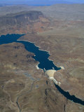
Lake Mead was formed by the Hoover Dam impounding the Colorado River. The dam serves as a source of electrical power, Lake Mead provides water for Southern California and cities such as Las Vegas.
The white edge of the reservoir is caused by the “bathtub ring” effect of high water mark. Since 2000 less than average snow fall in the Western Colorado Rockies is dropping the lake level, threatening both power generation and water for cities.
|
|
|
|
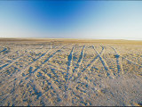
Dry Lake Bed
A large basin most of the time, Lake Eyre is the largest lake in Australia when filled with water during the rainy season. Lake Eyre is named for British explorer Edward John Eyre who was the first European to travel the Great Australian Bight coastline by land.
|
|
|
|
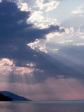
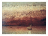
Lake Geneva, (French Lake Léman), is the second largest freshwater lake in Central Europe (after Lake Balaton) and is under both Swiss and French jurisdiction.
Gustave Courbet (1819-1877), whose work eschewed the predominant Romantic & Neoclassical schools of 19th century French painting, coined the term ‘realism’. Courbet chose to work spontaneously, without refinement, which was a visual precursor to the Impressionists.
|
|
|
|
|
|
|
Walden Pond
National Geographic
• Thoreau posters
I haven't found an “official” limitations on size that proscribe what body of water surrounded by land can be called a “lake” although I did find “The Highest Lake“, whose author Carl Drews suggests these working definitions of a lake.
1. A lake surface area must be at least 1 hectare, or 2.471 acres.
2. A lake must be at least 2 meters deep somewhere to allow for swimming.
3. A lake must be mostly open water. If you can hike across it, it's not a lake, it's a marsh. **
4. The lake must lbe able to support an environment for fish that last throughout the entire year. (100 cubic meters of liquid water year-round, 10x10 meters by 1 meter deep). A lake may have permanent surface layer of ice, like Lake Vostok in Antarctica
5. Someone has to visit the lake on the ground to verify and document it (this is most difficult for “highest lake” status).
|
|
|
**On the family farm we have what is referred to as “the swamp”. Geographically and geologically it is the very shallow “seventh” lake in a string of six lakes, appropriately enough called “Six Lakes”. My mother recalled skating on open areas of ice when she was a little girl, but another land owner broke up beaver dams and drained a section to create crop acreage calling it “the muck”, (nothing more descriptive need be offered). “The swamp” I remembered, didn't offer enough clear area to permit skating, very rarely was there ever enough water to even qualify for any part of it to attain “pond” status and my sister and I did walk across its frozen ground once in the winter. Forty years later, when the environmental movement had educated enough people to recognize the value of wetlands, and the economic reality of maintaining drainage were factored into the bottom line, enough water accumulated to float a boat during a wet year.
|
previous page | top
|
|
I have searched the web for visual, text, and manipulative curriculum support materials - teaching posters, art prints, maps, charts, calendars, books and educational toys featuring famous people, places and events - to help teachers optimize their valuable time and budget.
Browsing the subject areas at NetPosterWorks.com is a learning experience where educators can plan context rich environments while comparing prices, special discounts, framing options and shipping from educational resources.
Thank you for starting your search for inspirational, motivational, and educational posters and learning materials at NetPosterWorks.com. If you need help please contact us.
|
|
|