|
|
Islands Posters
for geography and social studies classrooms, home schools.
|
world geography > landforms > ISLANDS < social studies
|
|
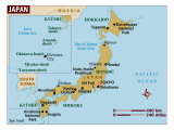
Islands are bodies of land surrounded by water, a chain of islands is called an archipelago. Australia is a continent that is also an island. Madagascar is an island nation; Japan, and the Philippines are nations situated on archipelagos.
The word archipeligo comes from the Greek arkhon “leader” and pelagos “sea” or “ocean”.
Island, Peninsula, and Cape Poster Text
Cape: A point or head of land, projecting beyond the adjacent coast into a body of water.
Island: Any piece of land, smaller than a continent and larger than a rock, which is completely surround by water. Very small islands are called islets. Groups of related islands are called archipelagos.
Atoll: A ring of coral islands or reefs usually surrounding an interior body of water called a lagoon. Atolls often mark the location of submerged mountain ranges or extinct volcanic islands.
Peninsula: A narrow extension of land surrounded on three sides by water, but connected to a larger land mass. Usually more extensive than a cape.
• Landform poster series -
|
|
|
|
|
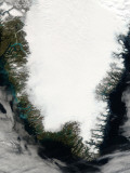
Greenland, located between the Arctic and Atlantic Oceans, east of the Canadian Arctic Archipelago, is the world's largest island that is not a continent (822,706 sq mi / 2,130,800 km2).
Greenland is geophyiscally part of North America, ethnically Arctic, and historically associated with Europe through Viking explorers.
June 2009 marks the recognition of Greenland as a separate country within the Kingdom of Denmark.
|
|
|
|
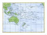
Australia, Tasmania, New Zealand, Malay
|
|
|
|
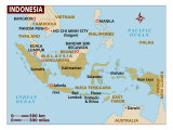
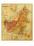
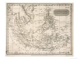
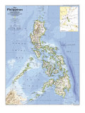
The Malay Archipelago, located between southeastern Asia and Australia has many groups of islands that are considered archipelagos on their own such as the Philippines.
The Malay archipelago includes the countries of Indonesia, the Philippines, Singapore, Brunei, Malaysia, East Timor, and most of Papua, New Guinea.
The biggest islands in the archipelago are New Guinea (the 2nd largest island on Earth), Borneo, Sumatra, Java, and Bali.
The Spice Islands, the source of early global conflict, are part of the archipelago.
|
|
|
|
|
|
|
|
|
|
|
|
|
The Republic of Madagascar is in the Indian Ocean, east of Mozambique. The island is the fourth largest in the world.
|
|
|
|
|
|
|
|
|
|
|
|
|
|
|
|
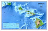
The Hawaiian Islands, the most isolated grouping of islands on Earth, is an archipelago of 137 islands, atools, islets, and undersea seamounts in the North Pacific Ocean.
The archigelago extendes some 1,500 miles from the Island of Hawaii in the south to the northernmost Kure Atoll. The Islands form the U.S. State of Hawaii.
|
|
|
|
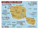
French Polynesia is the governing body of several groups of Polynesian islands in the South Pacific Ocean about half way between South America and Australia. Tahiti is the most populous island and artist Paul Gauguin immortalized the tropical island with his paintings.
|
|
|
|
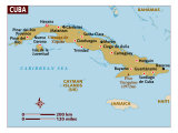
Caribbean Islands of Cuba, Bahamas, Cayman, Jamaica and Haiti
• maps posters
|
|
|
|
|
|
|
Easter Island, part of Chile, is a Polynesian island in the southeastern Pacific Ocean, at the southeastern most point of the Polynesian triangle (Hawaii and New Zealand are the other points of the triangle). Easter Island is famous for its monumental statues, called moai and much of the island is protected as a World Heritage Site. The name “Easter Island” was bestowed because the first European siting was on Easter Sunday, 1722.
|
|
|
|
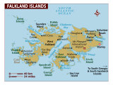
The Falkland Islands are a 776 island archipelago in the South Atlantic Ocean 300 miles east from the coast of Argentina and 584 miles north of Antarctica's Elephant Island. They are on a projection of the Patagonian continental shelf and are classified as part of the Antarctic ecozone.
The islands are a self-governing Overseas Territory of the United Kingdom, but have been the subject of a claim to sovereignty by Argentina since the British invasion of 1833, and an invasion and defeat of the Argentinian forces in 1982.
|
|
|
|
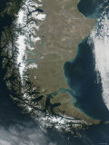
Tierra del Fuego, an archipelago off the southernmost tip of South America, across the Strait of Magellan. The archipelago's main island, Isla Grande de Tierra del Fuego, is divided between Chile and Argentina; one of the smaller islands includes Cape Horn, named after the city Hoorn in the Netherlands and for awhile was thought to be the southernmost point of Tierra del Fuego (Diego Ramírez Islands).
|
|
|
|
Isle Royale, an island located in the northwest of Lake Superior, is considered a part of the state of Michigan.
|
|
|
previous page | top
|
|
I have searched the web for visual, text, and manipulative curriculum support materials - teaching posters, art prints, maps, charts, calendars, books and educational toys featuring famous people, places and events - to help teachers optimize their valuable time and budget.
Browsing the subject areas at NetPosterWorks.com is a learning experience where educators can plan context rich environments while comparing prices, special discounts, framing options and shipping from educational resources.
Thank you for starting your search for inspirational, motivational, and educational posters and learning materials at NetPosterWorks.com. If you need help please contact us.
|
|
|