|
|
|
|
|
|
|
|
|
|
|
|
|
|
|
|
GEOGRAPHY TEACHING RESOURCES
|
|
|
|
|
|
|
|
|
|
|
|
|
|
|
|
|
|
|
|
|
|
|
|
|
 |
|
|
|
Famous & Notable Geographers Posters, Charts, Photographs
with atlas, cartographers, travel ideas, images and illustrations for classrooms and homeschoolers.
|
social studies > world geography | GEOGRAPHERS | explorers < landforms < Earth from Space
A geographer is a scientist who studies the Earth's physical environment and human habitat, as well as the relationships of human and wildlife ecologies, weather and climate patterns, economics, and culture.
Historically a geographer was involved in cartography, or map making. Modern geographers often find employment with government agencies and private environomental firms to resolve environmental problems.
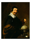
Spanish portrait artist Diego Velazquez (1599-1660) painting The Geographer, illustrates the rising influence and prominence of scientific enquiry in Europe at the time.
|
|
|
|
Atlas Geographique illustrates the art and science of geography as perceived at the beginning of the 20th century. Surrounded by the natural world, representatives of the Americas, Middle East, Asia and Africa, gather about a seated figure of Europe who instructs the other continents and peoples from the book in her lap. Empiricism, anyone?
The Atlas Novus, also known as Atlas Major, was completed in 1665. It was a comprehensive world atlas, conceived by Willem Blaeu and compiled by his son Joan (Johann) Blaeu. The original full title was ‘Theatrum orbis terrarum, sive, Atlas novus’ consisted of eleven volumes, in Latin, and containing 594 maps. • History of Posters
Wonder where the word “atlas” comes from?
Atlas the Titan - In the mythological battle between the Titans and the Olympians, the victor Zeus condemned the defeated Atlas to keep the Earth and Sky separated forever. Atlas is depicted holding up the celestial sphere and standing on the Earth.
Learning this story is a great relief to my childhood question of ‘what was Atlas standing on if he was holding up the Earth?’
And guess what? - this isn't the “Atlas” that lent the name to the “bound collection of maps” that we call an ‘atlas’ today. The use of the word atlas can be traced back to the cartographer Mercator who dedicated his collection of maps to the mythological King Atlas of Libya, though he did not include the name in his title. Oh - and then there are the Atlas Mountains in northwest Africa.
|
|
|
|
Leo Africanus
born al-Hasan ibn Muhammad al-Wazzan al-Fasi
b. c. 1492; Granada, Spain (raised in Fez)
d. c. 1554?; Tunis?
The Moor and diplomat Joannes Leo Africanus is best remembered for his Descrittione dell’Africa (Description of Africa). It has been suggested that Leo Africanus was the inspiration for Shakespeare's Othello.
• Leo Africanus; A Man Between Worlds - BBC video
|
|
|
|
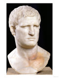
Marcus Vipsanius Agrippa
c. 63 BC - 12 BC, Roman Empire
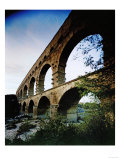
Agrippa, a Roman general, statesman, and architect, was also a geographer, charged with doing a survey of the Roman Republic/Empire by Augustus.
He is also noted as improving the civic infrastructure of Rome which included aquaduct and the sewer system repairs, and the designing first Pantheon (pan = all + theon = gods) which was destroyed by fire in 80 AD.
FYI - Agrippa's legacy includes his grandson Caligula, and great-grandson Nero.
• Augustan Rome |
|
|
|
Jared Diamond
b. 9-10-1937; Boston, MA
Jared Diamond, a professor of geography and physiology, has published more than two hundred articles and several books including the bestseller “Guns, Germs, and Steel,” which was awarded the Pulitzer Prize. Using evidence from ecology, archaeology, genetics, linguistics, and historical case studies, Diamond postulated that “gaps in power and technology in human societies ... originate in environmental differences powerfully amplified by various positive feedback loops.”
|
|
|
|
|
|
|
Richard Hakluyt
b. c. 1552/3; London (?), England
d. 11-23-1616; London
The first serious English geographer William Hakluyt gathered accounts about the wide-ranging travels and discoveries of the sixteenth-century explorers. Intended to assist navigation and trade, Hakluyt's writing also advocated for colonies in North America.
• English Colonization ...“may staye the spanische Kinge from flowinge over all the face” of North America, wrote geographer Richard Hakluyt in 1584 - see the 1988 Nat'l Geog. Tidewater map
|
|
|
|
|
|
|
Cosmas Indicopleustes
b. c. 500 AD; Greece
d. c. ?
Sixth century traveller, merchant and monk, Cosmas Indicopleustes of Alexandria, wrote Topografia Christiana (Christian Topography) which contains some of the earliest and most famous world maps.
His name literally means “who sailed to India”.
|
|
|
|
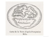
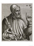
Pomponius Mela
b. c. 1 AD; probably southern Spain
d. c. ?
Pomponius Mela was the earliest Roman geographer and author of De situ orbis libri III.
Pomponius divided the earth into five zones, a northern and southern habitable temperate zones separated by a torrid belt at the equator, and two frozen climates. He also asserted the existence of antichthones (Gk. contra+terra) those peoples who inhabit countries on opposite sides of the Earth.
|
|
|
|
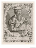
Gerardus Mercator
b. 3-5-1512; Flanders
d. 12-2-1594: Duisburg
Cartographer Mercator made a cylindrical map that was the favorite of navigators and explorers because it could represent lines of true course, today we know that kind of map as a Mercator Projection.
What would you think if you were told Mercator was a precursor to Henry Ford? Mercator developed a technique to mass produce globes with paper mache, which was much faster than hand carving a block of wood or metal. Mercator's mass production technique made a spherical map less expensive and therefore available to more people. Who else was mass producing information?
Mercator was friends with mathematician John Dee.
|
|
|
|
|
|
|
|
|
|
David Thompson
b. 4-30-1770; London, England
d. 2-10-1857; Montreal, Canada
Fur trader, surveyor, and map-maker, David Thompson explored North America west of Hudson Bay and Lake Superior, across the Rocky Mountains to the source of the Columbia River, and followed the length of the Columbia to the Pacific Ocean. He has been described as the “greatest land geographer who ever lived” and known to some native peoples as “Koo-Koo-Sint” or “the Stargazer”.
FYI ~ Thompson apprenticed to the Hudson Bay Company at age 14, clerking in present day Manitoba; Thompson was the creator of maps used by Lewis and Clark.
|
|
|
|
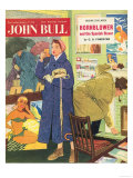
John Bull, Holiday Travel Agents Magazine, UK, 1950
|
|
|
previous page | top | world geography | GEOGRAPHERS
|
|
I have searched the web for visual, text, and manipulative curriculum support materials - teaching posters, art prints, maps, charts, calendars, books and educational toys featuring famous people, places and events - to help teachers optimize their valuable time and budget.
Browsing the subject areas at NetPosterWorks.com is a learning experience where educators can plan context rich environments while comparing prices, special discounts, framing options and shipping from educational resources.
Thank you for starting your search for inspirational, motivational, and educational posters and learning materials at NetPosterWorks.com. If you need help please contact us.
|
|
|