|
|
|
|
|
|
|
|
|
|
|
|
BOOKS ABOUT CITIES & URBAN PLANNING
|
|
|
|
|
|
|
|
|
|
|
|
|
 |
|
|
|
|
|
|
|
|
Ahmedabad, in the Indian state of Gujarat, is the seventh largest city and seventh largest metropolitan area of India, with a city population of approximately 4.0 million and metropolitan population of 5.4 million.
The city was founded in 1411, during the British colonial period it was known as the “Manchester of the East” for being a center of textile industry, and then as a leader in the Indian Independence movement. Today Ahmedabad is a center of culture and commerce.
• India Cities
|
|
|
|
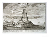
Alexandria, Egypt, was founded by Alexander the Great in 332 BC on the site of a fishing village called Rhakotis, at the mouth of the Nile River.
Hippodamus, the first “city planner”, laid out Alexandria in a grid plan, Dinocrates was the chief architect, and Alexander's general Ptolemy, built the city that was famous for its lighthouse (one the Seven Wonders of the Ancient World) and its library.
As of 2006, Alexandria's population was over 4 million people. Famous citizens of Alexandria include Saint Athanasius, Cleopatra, Cosmas Indicopleustes, Hypatia, Claudius Ptolemaeus, Eratosthenes, Euclid, and Origin.
|
|
|
|
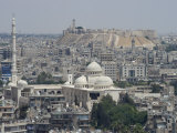
Aleppo, the largest city in Syria, and one of the largest cities in the Levant (Eastern Mediterranean area), is also one of the oldest cities in the world. Aleppo was the terminus of the Silk Road.
Aleppo was first mentioned in cuneiform tablets c. 3,000 BC. With the opening of the Suez Canal in 1869 Aleppo began losing its importance as a trading center and dropped from its previous prominence.
|
|
|
|
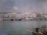
Algiers is the capital and largest city of Algeria. It is located on the Mediterranean coast of Africa. The name is from an Arabic word which means “the islands”, for the islands that became part of the mainland in 1525.
Algiers began as a trading outpost by the Phoenicians, was a Roman outpost, and then came under the control of the Berbers. In 1510 the Moors who had been expelled from Spain, were invited to expel the Spaniards from the islands; the Ottoman Empire was invited to rule and then Algeria became a center for the Barbary (Berber coast) pirates. In 1830 the French colonized Algiers for over 130 years (the French Foreign Legion).
|
|
|
previous page | top | next
Cities of the World | A | AH-AL | Am-An | Ar-Az | b | c | d | e-f | g | h | i | j | k | l |
m | n | o | p | q | r | s | t | u | v | w | x-y-z
|
|
I have searched the web for visual, text, and manipulative curriculum support materials - teaching posters, art prints, maps, charts, calendars, books and educational toys featuring famous people, places and events - to help teachers optimize their valuable time and budget.
Browsing the subject areas at NetPosterWorks.com is a learning experience where educators can plan context rich environments while comparing prices, special discounts, framing options and shipping from educational resources.
Thank you for starting your search for inspirational, motivational, and educational posters and learning materials at NetPosterWorks.com. If you need help please contact us.
|
|
|