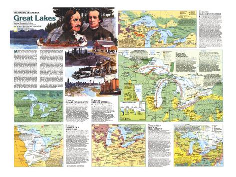
* Lesson plan idea - have your students update the information and latest statistics concerning the Great Lakes of the United States; discuss, contrast and compare the political, economic (employment), and environmental (climate change) situations the Midwest region is dealing with currently. • maps
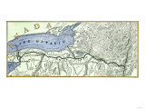
Great Lakes States map text -
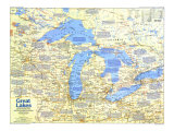
MARITIME WORLD in the heart of a continent, the Great lakes deserve their name. These five inland seas hold a fifth of Earth's fresh surface water. Extending more than 800 miles from east to west, their waters lap at 8,000 miles of shore and cover an area larger than Illinois and Michigan.
In the early 1600s, some 10,000 years after melting ice sheets had begun to fill the lake basins, the French penetrated this forested country. By the 1700s British fur trappers and Iroquois Indians were undermining the lucrative trade between the French and Algonquian tribes. The ensuing French and Indian War of 1754-1763 was the decisive square-off in North America between the European powers. Victorious Britain passed the Quebec Act in 1774, which expanded the predominatly French province into lands claimed by seaboard colonies. Effectively barring settlement beyond the Ohio Valley, the act helped fuel the American Revolution.
Although Britain and the new United States agreed on an international boundary bisecting the Great Lakes in 1782, British fur traders and their Indian partners continued operation on the U.S. side. They gave ground only after 1794, when Gen. Anthony Wayne defeated the Indians at Fallen Timbers (battle site near present day Toledo, Ohio).
Transportation improvements and Indian land cessions allowed Michigan to grow faster than any other territory or state in the 1830s. By 1837–Michigan's year of statehood–the population had risen from 31,600 to 174,500. Indians yielded the last of their Wisconsin land in 1848, and another frontier region joined the Union.
Following the Civil War, the nation demanded wood and minerals. Timber from the northern lakes helped build cities in the Midwest and farmhouses on the treeless Great Plains. In the 1880s an '90s Michigan produced not only more lumber than any other state but also more iron ore and copper.
Logging plunder left a cutover wasteland, which newcomers struggled to farm. But El Dorado lay along the southern lakes in new steel mills and automobile assembly plants. Manufacturing, boosted by two World Wars, expanded westward along the Great Lakes–a liquid conveyor belt for bulk goods. When President Dwight D. Eisenhower dedicated the U.S.-Canadian St. Lawrence Seaway on June 26, 1959, he called it a “magnificent symbol” of the enduring friendship of two nations. The waterway gave large oceangoing vessel access to the lakes. In the 1970s U.S. manufacturing ran afoul of global economic ills, foreign competition, poor management, and extravagant wage pacts. Ten of thousands left the so-called Rust Belt for the Sunbelt.
As the region confronts the future, Lake Erie stands as a symbol of hope. Deadened only a generation ago by industrial pollution, the lake once again sustains life.
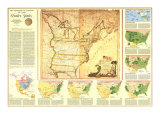
1. 1600-1775, INDIANS, FRENCH, BRITISH - SEEKING the legendary Northwest Passage to the Orient in 1634, the French explorer Jean Nicolet paddled into what is now Green Bay, Wisconsin. Frenchmen also came for furs and to save Indian souls. Voyageurs from Quebec and Montreal canoed to Fort Michelimackinac via the Ottawa River and Georgian Bay. They avoided the southern Great Lakes, guarded by pro-British Iroquois who systematically defeated the French-allied Huron, Petun, and a group called Neutrals.
Although an English colonial governor warned in the 1680s that the French presence could be “very inconvenient,” the French and Indian War did not begin until 1754. In the struggle for the interior, Britain eventually won the pivotal Niagara corridor between Lakes Erie and Ontario. After the war Scots dominated the fur trade, stripping the southern lakes region by the mid-1770s.
CONTEST FOR THE CONTINENT - Although Sieur de Cadillac began building Fort Detroit in 1701, the British did not make a countermove until 1727, when they put up Fort Oswego. In 1759 Britain seized Fort Niagara; Montreal fell soon afterward. The subsequent surrender of the garrisons at Detroit and Michilimakinac signaled the end for France.
PIONEERS FOR GOD - Sault Ste. Marie, the headquarters of New France's western missions, was established in 1668. The Jesuit missionary Father Allouez founded St. Francis Xavier Mission in 1671. That same year at St. Ignace Mission, Father Marquette began work on what he described as the “untutored minds” of the Ottawa and Huron.
2. 1776-1820, CREATION OF A BORDERLAND - AFTER THE REVOLUTION ended in 1783, as many as 10,000 pro-British colonist emigrated north of Lake Erie. In 1791 the colony of Upper Canada was formed to accommodate these and other Loyalists. Upper Canada's governor, John Simcoe, encouraged American immigration, and many “late Loyalists” settled in towns such as Hamilton.
Although Britain surrendered much of future Michigan and Ohio in 1783, the crown retained the crucial Ottawa River route to northwestern fur grounds. Hoping to break the grip of the British North West Company, the U.S. adopted the “factory” system, whereby agents traded goods for furs at government posts, or factories. Most Indians, however, preferred dealing with free-ranging independents who supplied superior products and rum.
The fledgling U.S. had another problem: a territorial map confused by the former colonial claim of five eastern states, among them Connecticut, whose Western Reserve was attracting hordes of farmers. Northwest Territory, organized in 1787, served as the administrative framework for new jurisdictions such as Michigan Territory, organized in 1805. Forts and fur posts were early nuclei for settlement, but the population grew slowly before Indians ceded their lands. In 1800 Detroit contained only 500 people, while Prairie du Chien and Green Bay together counted barely 100. Within two decades this vast frontier would begin to beckon, but for many Easterners the words of a contemporary rhyme said it all:
Don't go to Michigan, that land of ills;
The word means ague, fever, and chills.
INDIAN LAND LOSSES - As whites pressure Great Lakes tribes to sign treaties, land became available for survey, sale, and settlement. A dozen tribes yielded huge areas at Fort Greenville (Indiana) in 1795. In 1807 the Wyandot emerged from the Treaty of Detroit with nothing but a small reservation on the Huron River. At the Treaty of Saginaw in 1819, Indians signed away some six million acres – almost one-sixth of Michigan's area.
THEATER OF WAR - The Great Lakes were a major theater in the two-year-long War of 1812. In 1813 Commodore Oliver Hazard Perry won a turning-point victory off Lake Erie's Put-in-Bay, where he crippled Britain's Great Lakes fleet. After peace was signed 1814, the British Parliament discouraged immigration to Canada by Americans. Canadian nationalism strengthened, making the international boundary a more real dividing line.
3. 1820-1860 INFLUX OF SETTLERS - NEW YORK STATE'S ERIE CANAL, opened in 1825, unlocked the region. The cost of shipping a ton of freight from New York City to Buffalo fell from $100 to less than $25. At Buffalo, newcomers transferred from canalboats to Detroit-bound steamers or sailboats. By the 1830s some 200,000 people were passing through Detroit each year. But Chicago, with railroads to the Mississippi by the 1850s, soon surpassed Detroit as the revolving door of the interior.
Town names such as Portsmouth, Burlington, and Quincy reveal a deep Yankee imprint. Large numbers of German farmers, as well as migrants from New York, Ohio, and Illinois, bought land in southeastern Wisconsin, and miners from Appalachia exploited lead deposits in southwestern Wisconsin. By 1840 the state was producing half the nation's lead.
CROSS-BORDER TRAFFIC - After the War of 1812 the British government encouraged Europeans to settle in Upper Canada. Many immigrants–Irish, Scots, and English–later moved to the U.S. side of the lakes, where jobs were plentiful. A number of former Loyalists and their descendants also abandoned Upper Canada and returned to the United States.
4. 1860-1890 LAKE-COUNTRY LUMBER - BY THE 1840s WORD WAS OUT in the northeastern U.S. that Michigan was a lumberman's dream. In the early 1850s a Wisconsin congressman was promoting his state as being blessed with “interminable forests of pine, sufficient to suplly all the wants of the citizens ... for all time to come.” Lumberjacks from Maine, New York, Ohio, Pennsylvnia, and Canada rushed in, and Michigan was the leading timber state by 1879.
Loggers first cut the softwoods–white pine chiefly–in the watersheds of the Chippewa and other major rivers. Logs were rafted downstream on the spring flood to mill towns within reach of markets such as Chippewa Falls, Wisconsin, accessible by rail, and Muskegon, Michigan, linked by lake steamer. By the 1870s American-owned tugboats were towing mammoth pine rafts from Canada's Georgian Bay rgeion to huge, steampowered sawmills lining Michigan's Lake Huron shore. Proliferation of logging railroads in the 1880s enabled year-round felling of remote pine and hardwood forest. Hardwoods such as maple and oak were in demand as hcarcoal for iron smelting and were coming into vogue as flooring.
Lumber went to Milwaukee–a city of 115,000 by 1880–Detroit, Cleveland, and Buffalo. Much more was hipped to New York City and to Chicago, where settlers bound for the plains bought precut houses. The explosive growth of Chicago derived largely from its location as a railhead at the tip of Lake Michigan.
THE NORTHERN GREAT LAKES - Rich in timber, iron ore, and copper, the northern lakes became a popular destination for Europeans. English, Irish, and German immigrants were followed by Finns, Poles, and Italians. Many of these newcomers worked alongside French Canadians in the lumber camps and mill towns. Milwaukee and other lake ports flourihed as transhippers of the region's minerals and lumber and of the wheat of the northern plains.
SPIN-OFF EFFECT OF LUMBERING - Logging, which entrailed clearing the land, and lumber cmps, which created demand for foodstuffs, stimulated farming. Speculators greatly exaggerated the agriculutral potential of the northern lakes region. By 1890 some 250,000 would-be farmers had abandoned northern Wisconsin in search of better land in such neighboring states as Iowa and Minnesota.
5. 1890-1960 - INDUSTRIAL POWERHOUSE - DURING the nation's industrial takeoff in the late 1800s, both the population and demand for manufactured goods and processed foodstuffs soared. The southern lakes region–near major resources of iron ore and coal and accessible by water and rail to the markets of the interior and eastern seaboard–was a magnet to industry. The lake ports of Hamilton, Cleveland, Detroit, and Gary emerged as steelmaking giants in the heart of one of the world's greatest concentrations of heavy manufacturing. Lakeside mills devoured iron ore shipped south from the Gogebic, Mesabi, and other Lake Superior ranges, as well as coking coal brought by railroad and lake boat from the coalfields of Illinois and Appalachia.
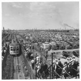
In 1908 Henry Ford's first Model T car rolled off the assembly line near Detroit. Within five years the annual output of these first mass-produced automobiles had jumped to 200,000. Detroit's population almost quintupled between 1890 and 1920 to 994,000, and that of Flint, headquarters of General Mortors, increased nine times, to 91,600. By 1950 U.S. automakers, centered in southeastern Michigan and dominated by Ford, General Motors, and Chrysler, were selling almost seven million cars and more than a million trucks annually. A complex industry that demanded vast amounts of steel and countless accessories, auto manufacturing sent economic waves throughout the nation.
DIVERSE ETHNIC HERITAGE - In 1910, when less than 15 percent of the U.S. population was foreign born, almost one-third of the residents in the northern lakes region had been born abroad. The cities of the southern lakes lured Poles, Italians, Hungarians, Greeks, and Czechs before 1920. Immigrants competed for factory jobs newcomers from Appalachia. Blacks from the Deep South flocked to Detroit and Chicago during the two World Wars. Subsequently, bad times in the copper-and iron-mining industries and farm failures forced thousands – some 225,000 between 1940 and 1950 alone – to leave the north country.
BUILDING A NAVIGABLE SYSTEM - Canals and locks between the lakes and long the St. Lawrence permit interlake travel by large vessels. In 1855 the Soo Canal linked Superior and Huron. Bypassing Niagara Falls, the eight-lock Welland Ship Canal, completed in 1932, permitted “upper lakers”– vessels up to 730 feet long and 75 feet wide and drawing 25.75 feet – to enter Lake Ontario. In 1959 the St. Lawrence Seaway, built to the same specifications, enabled bulk-carrying oceangoing “salties” to reach the lakes. A new lock at Sault Ste. Marie allows passage of 60,000-ton lakers up to 1,100 feet long and 105 feet wide; today about 30 ply (1987 data) the lakes west of Buffalo.
6. 1960 TO PRESENT (1987) - REGION IN READJUSTMENT - IN 1983 A MAMMOTH STEEL PLANT in Lackawanna, New York, shut down its blast furnaces permanently, leaving thousands of people jobless and hundreds of acres of Lake Erie waterfront an industrial graveyard. The nosedive of American manufacturing that began in the 1970s was as steep as its ascent had been following World War II.
Competiton from Europe and later from Japan, Brazil, and South Korea – where steelworkers earn only on-seventh as much as their U.S. counterparts – hit hard. Japan, quick to adopt the latest technology, forged ahead of the U.S. as the world's largest steel producer. The substitution of ligthweight plastics and aluminum for steel hammered the industry harder. Meanwhile U.S. automakers floundered under an invasion of fuel-efficient foreign cars; in Michigan car and truck output halved between 1976 and 1980.
Plant closings throughout the North American manufacturing belt squeezed the life out of the metropolises of the Great Lakes. Detroit's population, for example, shrank from 1,514,000 in 1970 to 1,203,000 a decade later. Although a number of people moved within the region, many migrated to the South and West, where the booming service and high-tech economy required them to learn new skills.
Readjustment has also been difficult for the millions who remain, but there are signs of a renaissance. Industries of a new age–from robotics and medical technology to communications and information processing–hold promise or the years ahead, and offices, recreational complexes, and apartments are rising out of the rust in downtown and waterfront areas.
RECREATION - Improved roads and an expanded network of interstate highways have boosted year-round recreation. Northern Wsconsin and Michigan, with their forests, trout- and salmon-stocked streams, and countless lakes, offer escape for urbanites. About half of all vacationers in northern Wisconsin come from metropolitan Chicago. Many citiies in the Great Lakes region are themselves tourist attractions. Holland, Michigan, for example, holds an annual ethnic-heritage festival that draws thousands.
TRENDS IN AGRICULTURE - Agriculture, the region's third economic cornerstone after manufacturing and recreation, has been eroded by a nationwide farm crisis. Manufacturers of farm equipment, concentrated in Illinois and Wisconsin, have suffered along with the farmers. Michigan leads the nation in the production of blueberries, tart cherries, and navy beans. Wisconsin, who stony glacial moraines are best suited to growing hay and pasture, ranks first in milk output.