|
|
|
|
|
|
|
|
|
|
|
|
BOOKS ABOUT
AFRICA & MALI
|
|
|
|
|
|
|
|
|
|
|
|
|
|
|
|
|
|
|
|
|
|
 |
|
|
|
|
|
|
|
|
|
|
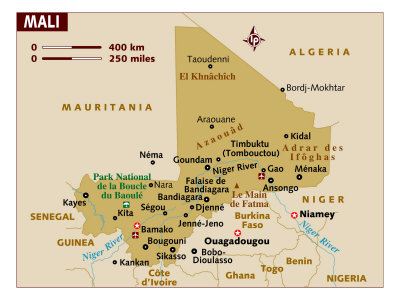
Mali Posters, Art Prints, Charts, Maps
for the geography and social studies classroom and theme decor for office or studio.
|
geography > Africa > MALI < social studies
|
The Republic of Mali is a landlocked western African nation and the seventh largest country in Africa, stretching from the Sahara Desert in the north to the Niger and Senegal rivers in the south.
Mali is bordered by Algeria on the north, Niger on the east, Burkina Faso and the Côte d'Ivoire on the south, Guinea on the south-west, and Senegal and Mauritania on the west.
Known as French Sudan during the African colonial period, Mali is named after the Empire of Mali. The name Mali comes from a native word for hippopotamus, the capital city is Bamako, means "place of crocodiles".
In 2012, a Tuareg rebellion claimed the regions of Timbuktu, Kidal, Gao, and a part of Mopti region, encompassing about 60 percent of Mali's claimed total land area and declared the Islamic Republic of Azawad. Azawad borders Burkina Faso to the south, Mauritania to the west and northwest, Algeria to the north and northeast, and Niger to the east and southeast, with undisputed Mali to its southwest. It straddles a portion of the Sahara and the Sahelian zone. Gao is its largest city and the temporary capital, while Timbuktu is the second largest city, and intended to be the permanent capital.
|
|
|
|
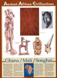
Ghana, Mali, Songhai-
Taken together, Ghana, Mali, and Songhai controlled most of western Africa for nearly 1,000 years. All three empires were fabulously wealthy and powerful, and their influence can still be felt in the culture and arts and sciences of modern West Africa. The civilization of Ghana was established durning the 5th and 6th centuries C.E. This hightly structured empire, which spread over the countries now known as Mauritania, Senegal, and Mali, was fueled by the huge gold reserves in the southern savanna lands. Visitors to Ghana were shocked to see how much gold the king (called “Ghana”) displayed in his royal palace – even the horses and dogs wore gold collars. Important trade routes helped Ghanan merchants to sell their ware all over Africa. But all the gold in Ghana could not save the empire when a group of Berber Muslims known as the Almoravids, invaded in 1076 and burned the capital.
After several centuries of fighting to control the trade routes, the Mandinka prince Sundiata Keita rose to power in the year 1233 and established the empire of Mali. This civilization, which lasted for more than 300 years, incorporated all the trade routes and land west of the Niger River as well as the gold reserves of the south. Timbuktu became the capital and soon earned a reputation as one of the most worldly cities in Africa, as well as one of the richest in the world. Arts and education flourished in the Islamic universities of Timbuktu. Malian sculpture became famous for its strong shapes. Musical storytellers called griots were the royal musicians, and the sound of a guitar-like instruments called the kora was soon heard all over western Africa.
But Mali began to weaken in the 1400s, when the empire became too big to manage. The Songhai people rose to power in 1464, under the leadership of Sonni Ber Ali, who eventually conqured Timbuktu and the leading city of Jenne. Ali and his successors ruled over the Songhai empire for more than 100 years, until it fell to Moroccan invaders.
While no great empire rose up to replace Songhai, the traditions of all three civilizations live on in the art, music, and traditions of modern Africa – and in the vibrant and sophisticated city of Timbuktu.
The Songhai Empire succeeded the declining Mali Empire and from the early 15th to the late 16th century was one of the largest African empires in history. The Songhai Empire was centered in eastern Mali and stretched through parts of present day Niger, Nigeria, Burkina Faso, Benin, Ghana, Senegal, Mauritania, and Guinea.
The first great king of Songhai was Sunni Ali, a Muslim like the Mali kings before him, who had derived great wealth through trade with Arabs. The Songhai Empire continued to be a strong trading economy with the goldfields of the Niger River a primary resource of the Songhai Empire. Gold was sometimes traded one to one for precious salt, a primary ingredient in food preservation.
• more Ancient African Civilizations posters
|
|
|
|
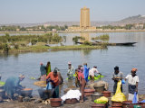
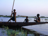
Bamako, the capital and largest city of Mali, is estimated to be the fastest growing city in Africa and sixth fastest in the world.
Bamako is located on the Niger River and the name Bamako comes from the Bambara language word meaning “crocodile river”.
|
|
|
|
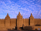
Djenne is located in the inland Niger Delta region of central Mali and the Bani River. Along with neighboring Timbuktu, Djenne was on the trans-Saharan trade route that flourished until the Portuguese opened trading posts on the coast.
Djenne is noted for both its distinctive mud-brick, or adobe, architecture and for the annual flooding of the Niger River that turn the city into an island.
|
|
|
|
Gao, on the banks of the Niger River, has been a commercial center in the trans-Saharan trade since the 9th century.
In late March of 2012 Gao was taken over from Mali by Ancar Dine rebels and the National Movement for the Liberation of Azawad, and declared the capital of the nation of Azawad (not yet recognized internationally).
|
|
|
|
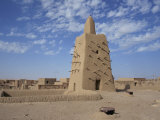
Timbuktu, in the West African nation of Mali, is situated on the southern edge of the Sahara Desert, just north of the Niger River.
Timbuktu began as a temporary settlement in the 12th century that became permanent with a shift in the trade route for salt, gold, ivory and slaves.
Today Timbuktu suffers the consequences of desertification though its name still evokes the aura of mystery that brings tourist dollars.
|
|
|
|
|
|
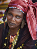
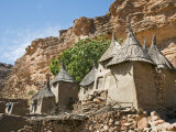
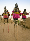
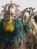
| The Dogon, an ethnic group living in the central plateau region of Mali, are best known for their religious traditions, mask dances, wooden sculpture and architecture.
• more mask making
|
|
|
|
|
|
|
|
|
|
|
|
|
|
|
previous page | top
|
|
I have searched the web for visual, text, and manipulative curriculum support materials - teaching posters, art prints, maps, charts, calendars, books and educational toys featuring famous people, places and events - to help teachers optimize their valuable time and budget.
Browsing the subject areas at NetPosterWorks.com is a learning experience where educators can plan context rich environments while comparing prices, special discounts, framing options and shipping from educational resources.
Thank you for starting your search for inspirational, motivational, and educational posters and learning materials at NetPosterWorks.com. If you need help please contact us.
|
|
|