|
|
|
|
|
|
|
|
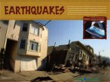
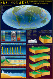
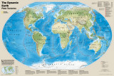
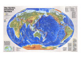
Like the pieces of a giant jigsaw puzzle, slabs of rocky crust known as tectonic plates fit together to form the Earth's outer shell. The puzzle changes as the plates slide over the hotter, softer rocks beneath them. Moving by mere inches annually, they reshape continents and oceans basins over the millions of years by colliding, separating and scraping past one another with relentless force. These interactions set off earthquakes, fire up volcanoes, and wrinkle the Earth's crust into mountains, valleys, and deep-sea trenches.
Most earthquakes occur near plate boundaries, where rock grinds past rock. Friction keeps the plate edges from sliding smoothly. The longer they remain stuck, the more strain builds and the more violent the snap and resulting vibrations – the earthquake.
|
|
|
|
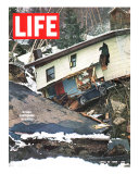
The 150 mile long New Madrid fault system was responsible for the 1811–1812 New Madrid earthquakes, and the 1895 Charleston, Missouri quake.
The fault line threatens southern Illinois and Indiana, Missouri, Arkansas, west Kentucky and west Tennessee, and has the potential for large destructive earthquakes in the future.
|
|
|
|
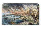
Lisbon, Portugal was nearly destroyed on November 1, 1755 by a earthquake in a 8.5-9.0 range whose epicenter was located 120 miles off shore in the Atlantic Ocean.
Lisbon was also hit by notable earthquakes in the 14th century (8), 16th (5), and 17th (3).
The Pombaline Lower Town (Baixa Pombalina), planned and built after the 1755 earthquake, is an early example of earthquake-resistant construction.
|
|
|
|
Port Royal, Jamaica, was the center of shipping commerce in the Caribbean until destroyed by an earthquake in 1692 (followed by fires, hurricanes, flooding), and then another earthquake in 1907.
The city of Kingston was founded as a refuge for the Port Royal earthquake survivors.
|
|
|
|
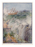
An earthquake with an estimated magnitude of 8.0 to 9.0 struck near Arica, Chile, killing an estimated 25,000 to 70,000 people on August 13, 1868. The earthquake created a tsunami recorded in Hawaii, Japan and New Zealand.
A subduction zone known as the Peru-Chile Trench, where the Nazca plate dives beneath the South American plate, threatens the region with megathrust earthquakes.
|
|
|
|
The San Andreas Fault, one of over 100 active faults in California, is a continental transform fault that runs approximately 810 miles. It is the source of most of the quakes in the state.
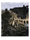
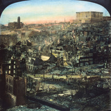
On the early morning of April 18, 1906 a magnitude 7.8 Mw earthquake and resulting fires destroyed 80% of San Francisco, with more than 3,000 deaths.
FYI ~
• Poet Laureate of California Ina Coolbrith's collection of books and papers were lost in the fire.
• The New York Metropolitan Opera with Enrico Caruso and Olive Fremstad performed Carmen at the San Francisco Grand Opera House on the evening of April 17th. The Met's artists survived, but all sets and costumes were lost. Caruso swore he never would return to SF, and he never did.
|
|
|
|
The September 1, 1923 earthquake on Honshu Island, Japan, devastated Tokyo, Yokohama, and moved the Great Buddha statue (93 tons) in Kamakura, nearly two feet.
The 1923 earthquake was the largest recorded in Japan until 2011 Tohoku earthquake.
|
|
|
|
The Great Alaskan Earthquake of Good Friday 1964 (March 27) was a magnitude of 9.2 with the epicenter located in Prince William Sound. The earthquake was in a subduction zone caused by the Aleutian Megathrust fault.
In the city of Anchorage buildings and infrastructure were destroyed by landslides and ground shifting in elevation. At Port Valdez there was a massive underwater landslide, tsunamis destroyed a coastal Alaskan village and damaged property in Hawaii, Japan, British Columbia, Oregon and California. Evidence of tremors – water sloshing in wells, fishing boat sinking in the Gulf of Mexico – were reported worldwide.
The Alaskan Earthquake stands as the most powerful North American earthquake and the 2nd most powerful recorded by seismograph after the 1960 Valdivia earthquake in Chile.
|
|
|
|
Pakistan -2005 earthquake registered a magnitude of 7.6 in the Kashmir area with casualties of 75,000 and injuries of 106,000. Kashmir lies in the area of collision of the Eurasian and Indian tectonic plates.
|
|
|
|
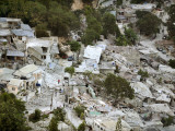
Haiti - 2010 earthquake was a magnitude 7.0 with an epicenter west of Port-au-Prince. An estimated 316,000 people died with 250,000 residences and 30,000 commercial buildings collapsed or severely damaged.
|
|
|
previous page | top
|
|
I have searched the web for visual, text, and manipulative curriculum support materials - teaching posters, art prints, maps, charts, calendars, books and educational toys featuring famous people, places and events - to help teachers optimize their valuable time and budget.
Browsing the subject areas at NetPosterWorks.com is a learning experience where educators can plan context rich environments while comparing prices, special discounts, framing options and shipping from educational resources.
Thank you for starting your search for inspirational, motivational, and educational posters and learning materials at NetPosterWorks.com. If you need help please contact us.
|
|
|