|
|
|
|
|
|
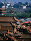
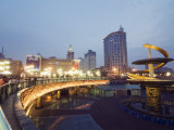
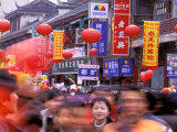
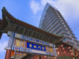
Beijing is the capital of the People's Republic of China. It is the political, educational, and cultural center of the country, Hong Kong and Shanghai predominate in economic fields.
The word “Beijing” means “northern capital”.
|
|
|
|
Chengdu, one of the most important economic, transportation, and communication centers in Western China, has been the site of human habitation for 4,000 years.
|
|
|
|
Chongqing, one of the five national central cities of the People's Republic of China, is possibly the world's largest municipality by population and one of the largest by area.
|
|
|
|
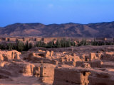
The ruins of Gaochang, an ancient oasis city built on the northern rim of the Taklamakan Desert in China, mark a stopping point for merchant traders traveling on the Silk Road.
|
|
|
|
Guangzhou is one of China's five National Central Cities, is located in the Pearl River Delta in the south China.
It is estimated the population of the Pearl River Delta is 40 millilon people.
The city is historically known as Canton.
Notable people associated with Guangzhou include I. M. Pei.
|
|
|
|
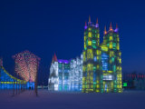
Haerbin is a key political, economic, scientific, cultural and communications hub in Northeast China.
Founded in 1898 as a stop on the Chinese Eastern Railway (an extension of the Trans-Siberian Railway funded by the Russian Empire) Haerbin has an international aura. Notable for its beautiful ice sculptures in winter, it has bitterly cold winters and is often called the “Ice City.”
|
|
|
|
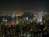
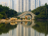
Hong Kong, is a city-state on China's south coast and enclosed by the Pearl River Delta and South China Sea renowned for its expansive skyline and deep natural harbor.
Hong Kong is one of the world's leading international financial centers.
|
|
|
|
Lou-lan was an important oasis city on the Silk Road along the north-eastern edge of the Lop Desert and near the brackish lake known as Lop Nur.
Loulan was rediscovered by Sven Hedin in 1899. His excavations revealed a wooden Kharosthi tablet and many Chinese manuscripts from the Later Han Dynasty (3rd century CE).
|
|
|
|
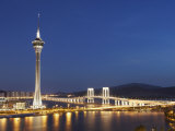
Macau, one of the two special administrative regions of the People's Republic of China, the other being Hong Kong, lies on the western side of the Pearl River Delta across from Hong-Kong.
Macau is a former Portuguese colony that was settled by Portuguese traders in the 16th century. It is both the first and last European colony in China.
|
|
|
|
Nanjing (Nanking), located on lower Yangtze River, served as the capital of China during several historical periods and is recognized as one of the Four Great Ancient Capitals of China (Beijing, Luoyang and Xi'an).
|
|
|
|
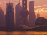
Shanghai, the most populous city in China and the most populous city proper in the world, is located at the middle portion of the Chinese coast, and sits at the mouth of the Yangtze River.
Shanghai began as a fishing village and grew to importance in foreign trade after the 1842 Treaty of Nanking.
Notable people associated with Shanghai include An Wang and Chien-Shiung Wu.
|
|
|
|
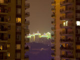
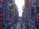
Shenzhen, located in the Pearl River Delta immediately north of Hong Kong, is one of the fastest growing cities in the world today.
|
|
|
|
Taipei is the capital of the island Republic of China (ROC), commonly known as “Taiwan” synonymous for the island.
FYI - the Portugese called the island Ilha Formosa, “Beautiful Island”.
|
|
|
|
Tianjin, in northern China, is one of the five national central cities of the People's Republic of China (Beijing, Shanghai, Guangzhou, and Chongqing).
|
|
|
|
Wuhan, the most populous city in Central China, lies on the Yangtze River. With a 2010 population of nearly ten million, Wuhan is a political, economic, financial, cultural, educational and transportation center, sometimes referred to as the “Chicago of China”.
In 1911, Sun Yat-sen's followers launched the Wuchang (one the three cities that joined to form Wuhan) Uprising that led to the collapse of the Qing Dynasty.
|
|
|
|
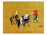
Xanadu - only ruins remain of Kublai Khan's summer capital Xanadu, located in what is now Inner Mongolia. It was destroyed by an invading Ming Dynasty army.
A reconstruction project has been undertaken and the site has been proposed as a UNESCO World Heritage Site.
From Marco Polo's description: “And when you have ridden three days from the city last mentioned, between north-east and north, you come to a city called Chandu, which was built by the Khan now reigning. There is at this place a very fine marble Palace, the rooms of which are all gilt and painted with figures of men and beasts and birds, and with a variety of trees and flowers, all executed with such exquisite art that you regard them with delight and astonishment. ...”
|
|
|
|
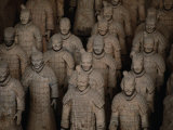
Xi'an, one of the Four Great Ancient Capitals of China and the eastern terminus of the Silk Road, has more than 3,100 years of history.
It is the home to the Terracotta Army, a 6,500 year old neolithic village was found on the outskirts of the city in 1954, and Lantian Man, a subspecies of Homo erectus was discovery nearby in 1963.
|
|
|
|
|
previous page | top
geography > Asia > China & Chinese Culture 1 | 2 | CHINA CITIES < List World Cities < social studies
|
|
I have searched the web for visual, text, and manipulative curriculum support materials - teaching posters, art prints, maps, charts, calendars, books and educational toys featuring famous people, places and events - to help teachers optimize their valuable time and budget.
Browsing the subject areas at NetPosterWorks.com is a learning experience where educators can plan context rich environments while comparing prices, special discounts, framing options and shipping from educational resources.
Thank you for starting your search for inspirational, motivational, and educational posters and learning materials at NetPosterWorks.com. If you need help please contact us.
|
|
|