GEOGRAPHY

Africa
Antarctica
Asia
Australia
Caribbean/West Indies
Central America
Cities
Europe
Explorers
Geographers
Landforms
Maps
Middle East
National Parks
North America
Canada
Mexico
USA
South America


CALENDAR

Vietnam Calendar 2011
Vietnam
Calendar


VIETNAM & VIETNAMESE CULTURE BOOKS

To Asia with Love: A Connoisseurs' Guide to Cambodia, Laos, Thailand and Vietnam

Vietnam: An Illustrated History
Vietnam:
An Illustrated History

Folk Stories of the Hmong Peoples of Laos, Thailand, and Vietnam

Folk Stories of the Hmong Peoples of Laos, Thailand, and Vietnam

Authentic Recipes from Vietnam

Oxford Picture Dictionary: English/Vietnamese


Vietnam Map muralVietnam Map
Wall Murals


Teacher's Best - The Creative Process

Vietnam & Vietnamese Culture Educational Posters & Prints
teaching and curriculum resources for the social studies classroom and home schoolers.

geography > Asia > Vietnam & Vietnamese Culture < Vietnam War Era < history < social studies


Vietnam Maps
Vietnam Maps

Vietnam Flag
Vietnam Flag

Southeast Asia Map, Giclee Print
Southeast Asia Map,
Giclee Print

Vietnam, with a rich 4,000 year history, is a small, s-shaped country located in Southeast Asia on the Indochina peninsula. Bordered on the north by China, the west by Laos and Cambodia, and on the south and east by the North China Sea, Vietnam is divided into the highlands and Red River Delta in the north and a mountainous region known as the Chaine, a coastal plain and the Mekong River Delta in the south. Vietnam has a tropical, monsoonal climate with occasional typhoons (hurricanes in the Western Hemisphere) with temperatures ranges influenced by the elevations.


Peoples of Mainland Southeast Asia Map 1971, Giclee Print

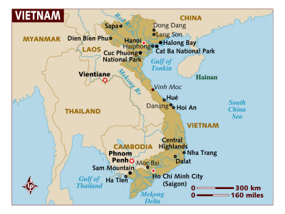
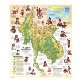
Vietnam - When Allied victory ended Japan's World War II occupation of the Union of Indochina in August 1945, the Communist-controlled Viet Minh created a Vietnamese republic embracing Tonkin, Annam, and Cochin China, with Hanoi as capital. The French re-established themselves in 1946. The fighting that broke out between them and the Viet Minh in December 1946 lasted until 1954. In May, a French force surrendered at Dien Bien Phu, and in July the Geneva agreements established a military demarcation line; the Viet Minh were to withdraw to the north of it, the French and those allied with them to the south. During the following year, the French quite the country, leaving behind the Vietnamese government they had established in Saigon. The demarcation line, never intended as a political or territorial boundary, nevertheless split the country into two parts: the Democratic Republic of Viet Nam – popularly, North Viet Nam; and the Republic of Viet Nam – called South Viet Nam. Each government demanded reunification on its own terms.

HUE - Once the Vietnamese imperial capital and a Cham center ... suffered severly from ground combat and bombing during the 1968 Tet offensive.

HO CHI MINH TRAIL - An extensive network of routes from northern Viet Nam through Laos and Cambodia, over which man and supplies flowed to Communist forces in southern Viet Nam and Cambodia. The trail's name, popularized by the Western press, refers to the late president of North Viet Nam.

TONKIN - From the 15th to 18th century the capital of Dai Viet was Hanoi, at one time called Dong Kinh. Visiting Europeans applied the name Tongking to the surrounding area. The French named the region Tonkin in 1883 and included it in the Union of Indochina.

ANNAM - Seventh-centruy Chinese colonist called this region Annam, meaning “pacified south” The indigenous people referred to it as Nam Viet and, and later, Dai Viet. The French used Annam to designate the region of present-day Viet Nam stretching along the S-shapped coast from Tonkin to cochin China. Until the end of World War II foreigners referred to the people of this area as Annamites or Annamese, but they have always called themselves Vietnamese.

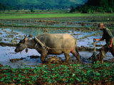
DAI VIET - The Vietnamese gained independence by rebelling against the Chinese in the tenth century. Gradually, they expanded to the south at the expense of the Chams. Though traditionally hostile to Chinese interference, the Vietnamese absorbed much of Chinese character; industrial and agricultural techniques adopted rom the north made them among the best farmers on the Southeast Asian mainland.

The French conquered the southernmost region of Viet Nam and ruled it as a colony. In contrast, tonkin and Annam were French protectorates, etaining some degree of autonomy.

SAIGON - Once called the “Paris of the Orient,” Saigon has traded its leisurely atmosphere for the ailments of a modern metropolis. Refugees from the Vietnamese was have made this one of the most densely populated cities in the world. Cholon, the Chinese section, holds 850,000 people–about a fourth of Saigon's population.

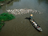
MEKONG RIVER & DELTA - Clled the “River of the Nine Dragons” for its many-mouthed delta, the Mekong rises high in the Asian heartlnd and travels 1,100 miels through Tibet and China before entereing the area of Southeast Asia. For much of its remaining 1,500 miles the river forms the border between Burma, Laos, and Thailand; some 30 million people live in its lower basin. Most traffic in the Mekong Delta moves on tributary canals, a complicated network of man-made waterways that take the place of highways in a nearly roadless land.

MONSOONS are peiodic wind systems that reverse directin during the year. Over mainland Southeast Asia they create two distinct seasons. Usually from October to April or May the northeast monsoon brings cool, dry weather. The southwest monsoon brings heavy rains, high humidity, and high tempertures from about May to September.

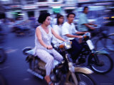
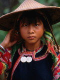
VIETNAMESE - Vietnamese-speaking peoples ... farm Viet Nam's coastal lowlands and the deltas of the Red and Mekong Rivers. They make up 85 percent of Viet Nam's 39 million people. Chinese influence, including the use of Chinese characters and the Confucian respect for ancestors, pervades Vietnamese culture. Women dress up in the traditional high-collared ao dai; conical hats are commonly worn by both men and women.

MNONG GAR - One of many Mnong-speaking groups of southern Viet Nam and Cambodia, the Mnong Gar cultivate dry rice by slash-and-burn agriculture, which they term “eating the forest.” The men wear loincloths and – occasionally – jackets, necklaces, and bracelets. For esthetic reasons they file down their front teeth and insert ivory plugs in their ear lobes. Their villages, made up of communal longhouses each functioning as a separate political unit, closely resemble those of the Rhade.

MONTAGNARDS - Almost two million Mon-Khmer and Cham-speaking tribes men occupy the rugged backbone of Laos, Viet Nam, and Combodia. Known collectively as Montagnards – French for “mountain men” – these isolated hill folk view with suspicion and distrust the lowland Vietnamese, who in turn regard them as savages.

RHADE - Upland rice farmers of southern Viet Nam, the Rhade live in villages notable for their distinctive longhouses built on piles. Partitioned into areas for work, social gatherings, and storage, the structures also include compartments occupied by family unites or older members of the household.

(sample poster text)

anthropology posters


Motor Bike Traffic on Crowded Streets, Ho Chi Minh City, Vietnam, Photographic Print
Motor Bike Traffic on Crowded Streets, Ho Chi Minh City, Vietnam,
Photographic Print

• more city posters

Planting Rice in Paddy with Ox, Sapa, Vietnam, Photographic Print
Planting Rice in Paddy with Ox, Sapa, Vietnam,
Photographic Print

cereals / food posters

Boatperson herding flock of ducks away from boat on Mekong Delta, Vietnam Photographic Print
Boatperson herding flock
of ducks away from boat
on Mekong Delta, Vietnam
Photographic Print

Portrait of Young Woman in Traditional Costume, Vietnam, Photographic Print
Portrait of Young Woman in Traditional Costume, Vietnam,
Photographic Print


Cao Dai Mid-Day Mass, the Cao Dai Temple, Tay Ninh (Near Saigon), Vietnam, Photographic Print
Cao Dai Mid-Day Mass, the Cao Dai Temple, Tay Ninh (Near Saigon), Vietnam,
Photographic Print

Tay Ninh is the holy site of Caodaism, one of Vietnam's indigenous religions.

Statue of the Buddha at Nhu Lai Temple, Vung Tau Peninsula, Vietnam, Indochina, Southeast Asia, Photographic Print
Statue of the Buddha at Nhu Lai Temple, Vung Tau Peninsula, Vietnam, Indochina, Southeast Asia,
Photographic Print

• more Buddhism posters

Cua Qua Hap Voi Bia Va Rua Vi (Steamed Crab in Beer and Herbs), Vietnam
Cua Qua Hap Voi Bia Va Rua Vi
(Steamed Crab in Beer and Herbs), Vietnam, Photographic Print

world cuisines posters

Traditional music, Ho Chi Minh City, Thoi Son Island, Vietnam, Photographic Print
Traditional Music, Ho Chi Minh City, Thoi Son Island, Vietnam,
Photographic Print

• more music posters

Boy Wearing Colourful Mask at Tet Nguyen Dan Celebrating Lunar New Year Holiday, Da Lat, Vietnam, Photographic Print
Boy Wearing Colourful Mask at Tet Nguyen Dan Celebrating Lunar New Year Holiday, Da Lat, Vietnam,
Photographic Print

• more masks posters

Water Puppets for Sale, Hanoi, Vietnam, Photographic Print


13th Hanoi Vietnam Indochina Fair Giclee Print
13th Hanoi Vietnam Indochina Fair
Giclee Print

Ha Long (Ha-Long) Bay, UNESCO World Heritage Site, Vietnam, Indochina, Southeast Asia, Photographic Print
Ha Long (Ha-Long) Bay, UNESCO World Heritage Site, Vietnam, Indochina, Southeast Asia,
Photographic Print


Alexandre Yersin, Giclee Print
Alexander Yersin,
Photogrpahic Print

Alexandre Yersin
b. 9-22-1868; Switzerland
d. 3-1-1943; Vietnam

Yersin, a physician and bacteriologist, was the co-discoverer with Kitasato Shibasabwsezuro, of the bacillus responsible for the bubonic plague.

“Plague” by Wendy Orent
• more health care posters


Afghanistan | Armenia | Azerbaijan | Bahrain | Bangladesh | Bhutan | Brunei | Burma | Cambodia
China | East Timor (Timor Timur) | Georgia | Hong Kong | India | Indonesia | Iran | Iraq | Israel
Japan | Jordan | Kazakhstan | North Korea | South Korea | Kuwait | Kyrgyzstan | Laos | Lebanon
Macau | Malaysia | Maldives | Mongolia | Myanmar | Nepal | Oman | Pakistan | Papua New Guinea
Philippines | Qatar | Russia | Saudi Arabia | Singapore | Sri Lanka | Syria | Taiwan | Tajikistan
Tibet | Thailand | Turkey | Turkmenistan | United Arab Emirates | Uzbekistan | Vietnam | Yemen

previous page | top


I have searched the web for visual, text, and manipulative curriculum support materials - teaching posters, art prints, maps, charts, calendars, books and educational toys featuring famous people, places and events - to help teachers optimize their valuable time and budget.

Browsing the subject areas at NetPosterWorks.com is a learning experience where educators can plan context rich environments while comparing prices, special discounts, framing options and shipping from educational resources.

Thank you for starting your search for inspirational, motivational, and educational posters and learning materials at NetPosterWorks.com. If you need help please contact us.


NPW home | Global PathMarker Collection | APWTW Blog | faqs-about | contact | search | privacy
links for learning & curriculum ideas | bookshelves | toybox | media | ecards | quotes

NetPosterWorks.com ©2007-2015 The Creative Process, LLC All Rights Reserved.

last updated 12/25/13