|
|
|
|
|
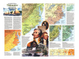
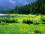
Tidewater, a geographic area, centers on Chesapeake Bay, largest of the submerged valleys between Delaware Bay and Pamlico Sound that began filling up as sea levels rose some 10,000 years ago at the end of the last Ice Age. It is part of the Atlantic Coastal region of North America.
The name is from the effects the changing tides of local rivers, sounds, and oceans has on the generally flat, low landscape of swamps and marshes. The higher areas were used for farming.
|
|
|
|
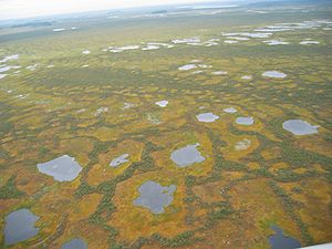
Vasyugan, located along the banks of the Ob River in western Siberia, Russia, is the largest swamp in the northern hemisphere.
It is home to a number of endangered species under threat as oil and gas production has become a major industry in the region.
|
|
|
|
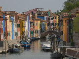
The Venetian Lagoon, an enclosed bay of the Adriatic Sea, is the largest wetland in the Mediterranean Basin.
The city of Venice is noted for its canals.
|
|
|
|
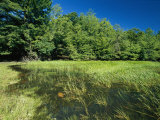
Vernal ponds are temporary pools of water formed when depressions fill with the winter snow melts and spring rains. The word vernal means “relating or occurring in the spring”.
Vernal pools allow for the safe development of amphibians and insects because they usually don't have fish who would feed on eggs and small creatures.
|
|
|
|
The Volga Delta, the largest river delta in Europe, occurs where the distributaries of Europe's largest river, drain into the Caspian Sea. The delta is the fishing grounds for beluga sturgeon, the source of beluga caviar . .
The wetlands formed by the delta, parts of which are designated as the Astrakhanskiy Biosphere Reserve, are important resting points and breeding grounds for migrating water birds.
|
|
|
|
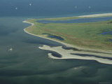
Wadden Sea is an intertidal zone in the southeastern part of the North Sea. It lies between the coast of northwestern continental Europe and the range of Frisian Islands, forming a shallow body of water with tidal flats and wetlands.
The Dutch and German parts of the Wadden Sea were inscribed on UNESCO's World Heritage List in 2009 due to its rich biological diversity.
The Wadden Sea coastline has been extensively modified by humans, via systems of dikes and causeways on the mainland and low lying coastal islands.
|
|
|
|
Wet meadows, once a common feature of Illinois and Michigan, are semi-wetlands that may occur because of poor drainage or the receipt of large amounts of water from rain or melted snow. They may also occur in riparian zones along a stream or river.
Many wet meadows have been drained and claimed for farming. Recent interest in how a wet meadow manages water flow has been integrated into rain gardens in urban setting, to allow stormwater to soak into the ground rather than be drained into sewer systems.
|
|
|
previous page | top
wetlands | a | b | c | d | e-f | g-l | m-n | o-p | q-s | T-Z
|
|
I have searched the web for visual, text, and manipulative curriculum support materials - teaching posters, art prints, maps, charts, calendars, books and educational toys featuring famous people, places and events - to help teachers optimize their valuable time and budget.
Browsing the subject areas at NetPosterWorks.com is a learning experience where educators can plan context rich environments while comparing prices, special discounts, framing options and shipping from educational resources.
Thank you for starting your search for inspirational, motivational, and educational posters and learning materials at NetPosterWorks.com. If you need help please contact us.
|
|
|