|
|
|
|
|
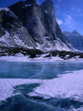
Germany's Jasmund National Park nature reserve in the northeast of Rügen island in the Baltic Sea.
Behind the famous and picturesqe chalk cliffs are many water-filled, undrained dells and hollows, most of which came into existence as ice-age dead ice holes.
|
|
|
|
Kettle lakes are shallow, sediment-filled bodies of water formed by retreating glaciers or draining floodwaters.
|
|
|
|
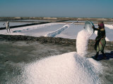
The Great Rann of Kutch is a seasonal salt marsh in the Thar Desert border region of India and Pakistan.
One of the hottest areas of India, the flat desert of salty clay and mudflats fill with standing water during the monsoon season.
The Kutch is the only place where flamingoes breed in Pakistan and India, and the area is famous for the world's last population of Indian Wild Ass.
The salt pans in the above photograph are probably near Dandi, the small village in the Gujarat state where Gandhi lead the Salt March act of civil disobedience, and are not part of the wetlands.
The Hindi word rann means “salt marsh”.
|
|
|
|
The Lena delta is frozen tundra for about 7 months of the year, the spring thaw in May transforms the region into a lush wetland for a few months. The Vasyugan Swamp, the largest swamp in the northern hemisphere, is a tributary of the Ob River.
The Lena River is the easternmost of the three great Siberian rivers that flow into the Arctic Ocean (Ob River and the Yenisei River). The Lena is the 11th longest river in the world and has the 9th largest watershed.
|
|
|
|
Limberlost Swamp is a wetland with mixed vegetation in Indiana; it is the western end of the Great Black Swamp of Ohio.
The Limberlost Swamp was the setting of Gene Stratton-Porter's popular novels A Girl of the Limberlost (1909) and Freckles (1904), as well as her numerous books on the swamp's natural life. The Girl of the Limberlost has been made into several movies.
|
|
|
|
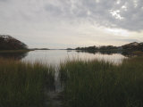
Long Island Sound is a long, narrow, and shallow estuary (a place where fresh and salt water mix) of the Atlantic Ocean, located between Connecticut to the north and Long Island, New York to the south, in the United States.
Long Island Sound is home to more than 1,200 species of invertebrates, 170 species of fish, and dozens of species of migratory birds live at least part of the year. More than 21 million people live within 50 miles of the sound.
|
|
|
previous page | top | next
wetlands | a | b | c | d | e-f | G-L | m-n | o-p | q-s | t-z
|
|
I have searched the web for visual, text, and manipulative curriculum support materials - teaching posters, art prints, maps, charts, calendars, books and educational toys featuring famous people, places and events - to help teachers optimize their valuable time and budget.
Browsing the subject areas at NetPosterWorks.com is a learning experience where educators can plan context rich environments while comparing prices, special discounts, framing options and shipping from educational resources.
Thank you for starting your search for inspirational, motivational, and educational posters and learning materials at NetPosterWorks.com. If you need help please contact us.
|
|
|