|
|
|
|
|
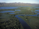
Okavango is an inland delta of the Okavango River, formed in a a basin, or low point, in southwestern African countries of Angola, Botswana, Namibia and Zimbabwe.
The Okavango also has salt pans at the lowest point of the basin.
|
|
|
|
Okefenokee, peat-filled wetland straddling the Georgia–Florida border in the United States, is the largest blackwater swamp in North America and one of the largest in the world.
The name Okefenokee is from an extinct native American language and meant “bubbling water” or “trembling earth”, describing the spongy bogs.
|
|
|
|
The Pantanal is a tropical wetland that lies mostly in Brazil and extends into Bolivia and Paraguay. It is an enormous inland river delta (see Okavango Delta).
|
|
|
|
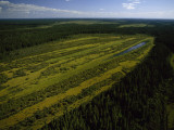
Peace-Athabasca Delta is a freshwater, inland delta in northeastern Alberta, Canada, located where the Peace and Athabasca Rivers join the Slave River at the western end of Lake Athabasca.
The marshes, lakes and mud flats of this area are an important habitat for waterfowl nesting and provides a staging area for migration.
|
|
|
|
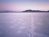
Playa lakes are dry lakes that under United States law, may be considered isolated wetlands, and may be eligible to enroll in the wetlands component of the Conservation Reserve Program (2002 farm bill).
|
|
|
|
Pocosin, a Native American word for “swamp on a hill” are waterlogged areas where dunes along a shoreline have affected the waterflow and created ponds that filled with decomposing plant matter.
|
|
|
|
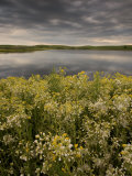
A prairie pothole is a shallow seasonal wetland where water gathers in depressions formed by glacier activity. These depressions were created during the most recent major advance of the North American Laurentide ice sheet (Wisconsin Glacial Episode), 10,000 years ago.
The praire pothole region is 276,000 sq. mi. of the Canadian provinces of Saskatchewan, Manitoba, and Alberta; and the US states of Minnesota, Iowa, North and South Dakota, and Montana. The potholes are important habitates of migratory waterfowl.
Kettle lakes is another name for potholes.
|
|
|
previous page | top | next
wetlands | a | b | c | d | e-f | g-l | m-n | O-P | q-s | t-z
|
|
I have searched the web for visual, text, and manipulative curriculum support materials - teaching posters, art prints, maps, charts, calendars, books and educational toys featuring famous people, places and events - to help teachers optimize their valuable time and budget.
Browsing the subject areas at NetPosterWorks.com is a learning experience where educators can plan context rich environments while comparing prices, special discounts, framing options and shipping from educational resources.
Thank you for starting your search for inspirational, motivational, and educational posters and learning materials at NetPosterWorks.com. If you need help please contact us.
|
|
|