|
|
|
|
|
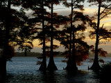
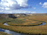
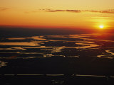
Reelfoot Lake, a shallow natural lake located in northwest Tennessee, was formed when land subsided during the 1811-1812 New Madrid earthquakes and the Mississippi River seemed to flow backwards.
Reelfoot, more of swamp, with bayou-like ditches connecting open bodies of water called basins, is noted for its bald cypress trees and its nesting pairs of bald eagles. It is a National Wildlife Refuge area.
|
|
|
|
Riparian zones are the interface between land and a river or stream. The riparian is an important feature of a wetland because it contributes to the wetland's overall health by filtering water and stabilizing soil while providing a natural habitat and wildlife corridor.
The word “riparian” is derived from Latin ripa, meaning river bank.
|
|
|
|
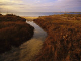
Salt Marshes occur in coastal tidal zones between land and salt/brackish water. A salt marsh is dominated by plants such as herbs, grasses, and /or low shrubs that are salt tolerant (halophytic).
|
|
|
|
A slough (*pronounce slew) can be defined as a muddy marsh in the British Isles; a swamp or shallow lake system with trees in the east and southeast United States, a secondary channel of a river delta (without trees) on the west coast of the US, or a pond on the prairies of North America.
Laura Ingalls Wilder described the Big Slough of South Dakota in her books “By the Shores of Silver Lake” and “The Long Winter”. “... Pa liked the Big Slough. ‘There are acres of hay there, that anyone can have for the cutting,’ he told Ma. ‘No one will ever take up homesteads in the Big Slough. There is only upland hay on our place, but with the Big Slough so near, we can always cut hay there and have all we need’.”
John Bunyan also used a slough in his allegory The Pilgrim's Progress where the character Christian sinks in the mire of the Slough of Despond.
|
|
|
|
Sudd Swamp, in South Sudan, Africa, is one of the world’s largest wetlands and the largest freshwater wetland in the Nile basin.
The word “sudd” is derived from the Arabic word “sadd”, meaning “block”. The Sudd is nearly impassable, either overland or by watercraft, and proved to be a block to the early explorers searching for the source of the Nile.
The long-running civil war in Southern Sudan seriously disrupted conservation efforts in the Sudd, especially as the widespread availability of weapons has encouraged poaching of wildlife, including elephants. There are three game reserves Zeraf Island: between the Zeraf River and the Nile, Shambe Reserve, and Mongalla Game Reserve.
|
|
|
|
The Sacramento Wetlands are part of the San Francisco Bay estuary in northern California, formed by the confluence of the Sacramento and San Joaquin rivers. The wetlands are a combination of marshes and sloughs, provides productive habitat for a diversity of aquatic flora and fauna.
The Suisun Marsh is named for a Patwin sub-tribe, the Suisunes, who inhabited the area around 200 years ago.
|
|
|
|
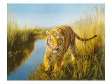
The Sundarbans, the largest single block of tidal halophytic (tolerate salinity) mangrove forest in the world, is located on the Bay of Bengal where the Padma, Brahmaputra and Meghna Rivers converge.
The fertile soils of the delta have been subject to intensive human use for centuries, and the ecoregion has been mostly converted to intensive agriculture, with few enclaves of forest remaining. The remaining forests, together with the Sundarbans mangroves, are important habitat for the endangered Royal Bengal Tiger (Panthera tigris tigris).
Sorry - could not locate a photograph of the Sundarbans mangrove forest.
|
|
|
|
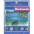
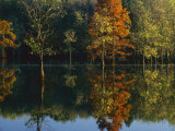
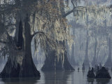
Swamps are wetlands with some flooding of large areas of land by shallow bodies of slow moving water.
A swamp generally has a large number of dry-land protrusions, or hammocks, covered by aquatic vegetation, or vegetation that tolerates periodical inundation.
|
|
|
previous page | top | next
wetlands | a | b | c | d | e-f | g-l | m-n | o-p | Q-S | t-z
|
|
I have searched the web for visual, text, and manipulative curriculum support materials - teaching posters, art prints, maps, charts, calendars, books and educational toys featuring famous people, places and events - to help teachers optimize their valuable time and budget.
Browsing the subject areas at NetPosterWorks.com is a learning experience where educators can plan context rich environments while comparing prices, special discounts, framing options and shipping from educational resources.
Thank you for starting your search for inspirational, motivational, and educational posters and learning materials at NetPosterWorks.com. If you need help please contact us.
|
|
|