|
|
|
|
An estuary is a partly enclosed coastal body of water with one or more rivers or streams flowing into it, and with a free connection to the open sea. Estuaries form the transition zone between marine and terrestial habitats.
Estuaries can be referred to by many different names, such as bays, harbors, lagoons, inlets, or sounds, although sometimes these bodies of water do not meet the definition of an estuary and may be fully saline.
Estuaries are amongst the most heavily populated areas throughout the world, with about 60% of the world’s population living along estuaries and the coast.
The word “estuary” is derived from the Latin word aestuarium meaning tidal inlet of the sea, which in itself is derived from the term aestus, meaning tide.
|
|
|
|
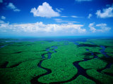
The Everglades are subtropical wetlands in the southern portion of the U.S. state of Florida. Several ecosystems make up the Everglades: sawgrass marsh, sloughs (free flowing channels of water), slightly elevated wet prairie; to the northwest is wet cypress forest protected by the Big Cypress National Perserve.
UNESCO and the Ramsar Convention designated the Everglades as one of only three wetland areas of global importance.
The Seminoles called it Pa-hay-okee that means “Grassy Water”; the name "Everglades" first appeared on a map in 1823.
• “The miracle of light pours over the green and brown expanse of saw grass and of water, shining and slowly moving, the grass and water that is the meaning and the central fact of the Everglades. It is a river of grass.” ~ Marjory Stoneman Douglas
|
|
|
|
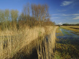
The Fens are a marshy area in eastern England, lying around the area of coast known as the Wash. The fens are similar to the low lands of the Netherlands. The Fens have been drained by pumps and protected from floods by banks for agricultural purposes.
Wetlands known as fens characteristically have neutral or alkaline water (as opposed to acidic bogs).
This area of England is also known for the many cathedrals, such as Ely. The name Ely comes from the Old English El-ge meaning “eel region” as the marshes were a home to eels.
|
|
|
|
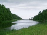
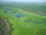
Floodplains, or flood plains, are the area near a river or a stream which floods easily. Floodplains are part of the riparian zone, the area along a river bank, and are important wetland habitats.
A floodplain is flat or nearly flat land stretching from the banks of a river channel to the base of the enclosing valley walls. The“ floodway” carries the main channel, the “flood fringe” are the areas which get covered by water but generally do not experience a strong current.
Floodplains are often important aquifers, the water drawn from them being pre-filtered compared to the water in the stream. Floodplains are particularly valuable to agriculture, for example the Nile River, the Fertile Cresent of the Tigres and Euphrates rivers, the Yellow River of China, the Indus of India, and “bottom land" along the Missouri River.
|
|
|
previous page | top | next
wetlands | a | b | c | d | E-F | g-l | m-n | o-p | q-s | t-z
|
|
I have searched the web for visual, text, and manipulative curriculum support materials - teaching posters, art prints, maps, charts, calendars, books and educational toys featuring famous people, places and events - to help teachers optimize their valuable time and budget.
Browsing the subject areas at NetPosterWorks.com is a learning experience where educators can plan context rich environments while comparing prices, special discounts, framing options and shipping from educational resources.
Thank you for starting your search for inspirational, motivational, and educational posters and learning materials at NetPosterWorks.com. If you need help please contact us.
|
|
|