|
|
|
|
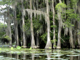
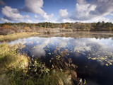
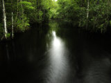
Caddo Lake and wetland, located on the border between Texas and Louisiana, is an internationally protected wetland under the RAMSAR treaty and features the largest cypress forest in the world.
Geologists believe the oxbow lake was formed by a log jam, called the “Great Raft”, damming Louisiana's Red River and filling depressions and basin, possibly caused by the New Madrid earthquake.
FYI ~ The name Caddo comes from the Native Americans called Caddoans or Caddo who lived in the area.
|
|
|
|
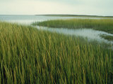
Cape Cod, a headland in the easternmost portion of the state of Massachusetts that extends out into the Atlantic Ocean, is about 25% wetlands. The marshes and bogs of Cape Cod host rare plants and act as a stopover for black ducks and other seabirds on the Atlantic flyway. The freshwater wetlands also filter and restore the Cape aquifer.
Revolutionary War veteran, Captain Henry Hall, became the first to commercially grew cranberries (1816), in the bogs of Cape Cod.
|
|
|
|
|
|
|
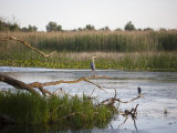
The Chesapeake Bay, the ria or drowned valley of the Susquehanna River, is the largest estuary in the United States. More than 150 rivers and streams drain the Chesapeake Bay watershed which covers the District of Columbia and parts of six states.
The wetlands along the bay, both tidal and non-tidal (palustrine) provide critical habitat for hundreds of species of fish, birds, mammals and invertebrates.
|
|
|
|
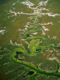
The Cheyenne Bottoms wetland is said to be the largest wetland in the interior United States. Located in central Kansas, the Bottoms have been lakes of varying sizes, a mudflat, or totally dry.
It is estimated that 45 percent of shorebirds in the United States stop at the marsh. At least 320 species of birds have been recorded there including numerous whooping cranes and thousands of sandhill cranes.
Both the Cheyenne Bottoms and the salt marshs to the southeast (protected in the Quivira National Wilflife Refuge) are in the Ramsar list of wetlands of international importance.
|
|
|
|
Chincoteague & Assateague are barrier islands along the Atlantic coast of Maryland and Virginia.
The islands and surrounding wetlands have been desingated as a World Biosphere Reserve and National Natural Landmark.
Assateague Island is notable for its population of feral ponies that were the subject of Marguerite Henry's story Misty of Chicoteague.
|
|
|
|
Congaree National Park of South Carolina preserves the largest tract of old growth bottomland hardwood forest left in the United States.
Most visitors to the park walk along the Boardwalk Loop, an elevated 2.4 mile walkway through the swampy environment that protects delicate fungi and plant life at ground level.
|
|
|
|
Big Cypress National Preserve in Florida is dominated by a wet cypress forest. The swampy area, next to the Everglades, is host to mangroves, orchids, alligators, venomous snakes like the cottonmouth and eastern diamondback rattlesnake, a variety of birds, and the Florida panther, and the Florida Black Bear.
The Big Cypress is also a traditional home of the Miccosukee and Seminole tribes, as well as early settlers who slaughtered herons and egrets to supply feathers to hat-makers in New York and Paris, and poachers who hunted American Alligators and Crocodiles to near extinction.
|
|
|
|
The Danube Delta is a low alluvial plain, mostly covered by wetlands and water. It consists of an intricate pattern of marshes, channels, streamlets and lakes as the Danube River empties into the Black Sea.
FYI ~ The Old Bavarian Donaumoos is a former bog on the southern side of the Danube river.
|
|
|
|
The Deep Bay at Hong Kong an internationally significant wetland that is actually a shallow estuary of several rivers. The Mai Po Marshes on the south shore are protected as a conservation area for mammals, reptiles, insects, and over 350 species of birds. The north shore is a high urban development area.
|
|
|
|
Great Dismal Swamp is a marshy area on the Coastal Plain Region of southeastern Virginia and northeastern North Carolina with Lake Drummond at the center.
In 1805 a canal was completed along the eastern edge of the swamp; it is now a part of the Intercoastal Waterway which shelters boaters from the Atlantic Ocean.
|
|
|
previous page | top | next
wetlands | a | b | C | d | e-f | g-l | m-n | o-p | q-s | t-z
|
|
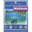
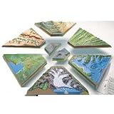
I have searched the web for visual, text, and manipulative curriculum support materials - teaching posters, art prints, maps, charts, calendars, books and educational toys featuring famous people, places and events - to help teachers optimize their valuable time and budget.
Browsing the subject areas at NetPosterWorks.com is a learning experience where educators can plan context rich environments while comparing prices, special discounts, framing options and shipping from educational resources.
Thank you for starting your search for inspirational, motivational, and educational posters and learning materials at NetPosterWorks.com. If you need help please contact us.
|
|
|