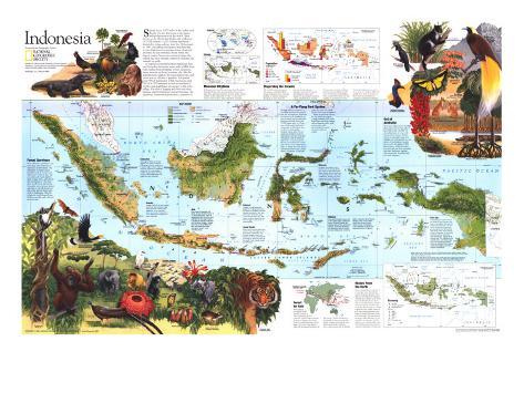
The 1996 Indonesia map side 2 features:
• Inset maps showing climate, rainfall, and population
• Maps and information about the timber industry, oil and gas production, mining, and other economic resources
• Illustrations of the flora and fauna of Indonesia, including some of the most unique animals in the world
• Information on the geography and wildlife of the region
• Wallace's Line which is the break between the Australian and Asian animal kingdoms
• Geographical details: mangrove, rainforests, grasslands, cultivated or inhabited areas, coral reefs, protected areas, volcanoes and more
• Airports
* Lesson plan idea - have your students update the information, discuss the political, economic, and environmental situations at time of publication and at date of their research. • maps
INDONESIA
Spread across 3,000 miles of the Indian and Pacific Oceans, Indonesia is the largest archipelago nation in the world. Once known as the Dutch East Indies, this collection of 17,000 islands – 3,000 of them inhabited – declared its independence from the Netherlands in 1945. Straddling the Equator and drenched in rain, Indonesia is a treasure house of natural diversity. Its vast stretches of rain forest, the largest outside Amazonia, contain perhaps the richest and most unusual collection of plants and animals on Earth.
A tropical crossroads between mainland Asia and Australia, Indonesia teems with wildlife from both realms, from elephants to tree kangaroos. Some animals are found nowhere else, like the giant Komodo dragon, the Javan rhinoceros, and seven species of birds of paradise. Altogether some 430 of Indonesia's 1,500 bird species and 200 of its 500 mammals as well as hundreds of reptiles and amphibians are unique to the archipelago. Decades of logging and slash-and-burn farming imperial Indonesia's natural heritage. An ambitious conservation plan aims to preserve it.
Kalimantan - Covering two-thirds of the biologically rich island of Borneo, Kalimantan remains a wild, thinly settled region, where travel is mostly by riverboat. In 1982-83, at the end of a rare drought, 13,000 square miles of forest burned in East Kalimantan, the largest fire ever recorded.
Sumatra - Though much of its lush lowland forest has been cleared, large areas of forest remain in the highlands. In the mountain parks are some of Indonesia's most significant populations of large mammals.
Java - One of Earth's geologic hot spots, Java is the fiery home of 17 active volcanoes. With its ash-enriched soil, it is the most cultivated of the large islands. It is also the country's political and industrial center. A population of 107 million ranks this New York State-size island among the world's most crowded places.
Sulawesi - Fringed by coral reefs and topped by smoking volcanoes, the island of Sulawesi (formerly Celebes) consists of four long peninsulas. Protected areas in the north contain such Wallacean endemic species as the babirusa pig and the anoa, a dwarf buffalo.
Lesser Sundas - Brush fires have denuded large areas in this island group, the driest part of Indonesia. The Komodo dragon lives in arid savanna on a few small islands. Surviving on Timor are some of the world's last natural sandalwood forests.
Moluccas - European sea powers once warred over the remote Moluccas, known to the world as the Spice Islands. Where cloves and nutmeg proliferated in the past, subsistence farmers not tend cassava and yams. The forest harbors 31 species of parrots.
Wallacea - Asian and Australian fauna mix in the island region called Wallacea. Situated between the shallow seas of two continental shelves, it includes Sulawesi, the Molluccas, and the Lesser Sundas. Wallacea is named for the British naturalist Alfred Russel Wallace, who, in the 1850s, discovered a now famous break–known as Wallace's Line – between the Asian and Australian animal kingdoms.
Irian Jaya - Comprising the western half of the island of New Guinea, irian Jaya is the largest and least developed of Indonesia's 27 provinces. Dense forest and mangrove swamp cover 85 percent of its area. Parts of the interior remain unexplored. In the cloud-drenched central mountains rises Indonesia's highest peak, Puncak Jaya. The highlands also contain Asia's only tropical glaciers. The Indonesian government has targeted Irian Jaya for accelerated logging and transmigrant settlements.
A Far-Flung Park System - With its wilderness habitats increasingly threatened by population and developement, Indonesia has carved out a remarkable system of nature reserves and parks. Existing protected areas cover 73,000 square miles, or 10 percent of Indonesia's land area. Among the world-famous sites are Java's volcano parks, Tanjung Puting park with its orangutan research center in Kalimantan, and the coral reefs of Bunaken park of Sulawesi. Proposed as a national park is Mount Lorentz Reserve in Irian Jaya, which covers 5,800 square miles, or nearly twice the area of Yellowstone Park in the Untied States. Altogether 30 national parks and some 150 nature reserves have been designated.
Many uncertainties remain for this ambitious system. A lack of trained staff, unenforced laws regulating logging and settlements, and a weak conservation ethic nationwide put numerous protected areas at risk.
Forest survivors
Room still exists – just barely – for many large Asian mammals on Indonesia's western islands. The endangered orangutan swings through treetops in Sumatra and Kalimantan. Unlike its East African cousins, the Asian elephant keeps to dense forest, joined by the tiger and rhinoceros. The Asian fauna is rich in cats and primates. Among the most important animals culturally are the high-flying hornbills, which figure in many tribal myth in Kalimantan. Plant life includes the world's largest flower, Rafflesia arnoldii, with a blossom three feet wide.
Out of Australia
Irian Jaya's unique array of wildlife dates back to the Ice Age, when a land bridge made it possible for Australian fauna to cross to the island of New Guinea. The 47 species of marsupials range from wallabies on the grasslands to a new species of tree kangaroo recently discovered in the highlands. With few predators, birdlife flourishes, most famously the birds of paradise with their flamboyant plumage. Also spectacular: butterflies with foot-wide wingspans.
Forest for Sale
With almost two-thirds of the country covered in forest, Indonesia has become the world's largest exporter of plywood. Most comes from Sumatra and Kalimantan, where loggers fvor the lofty dipterocarps, the dominant hardwood in th canopy. Timber production is running far above sustainable levels. Logging and farming strip 4,700 square miles of forest a year, a rate second only to Brazil's.
Riches From the Earth
Since independence, exports of oil and gas have driven Indonesia's economic growth. The richest oil fields lie off Sumatra. Though the collapse of oil prices has forced Indonesia to diversify into manufacturing, natura resources remain crucial to the economy. The country is a major exporter of tin, nickel, and copper. Agriculture dominates the home economy. Because of past food shortages, the government promotes self-sufficiency in rice and plans to turn part of Kalimantan into a giant paddy zone. Poor infrastructure has limited resource exploitation in the east.
Monsoon Rhythms - Indonesia receives its heaviest rains from December through March, when monsoons blow from mainland Asia, gathering moisture over the Indian Ocean and the South China Sea. A “dry”– or less wet – season arrives in June with winds from Australia.
Dispersing the Crowds - The world's fourth most populous nation, with 200 million people, Indonesia faces a chronic problem of uneven population distribution. More than 60 percent of its people are crammed onto Java. To spread development to the outer islands, the government sponsors a huge transmigration program.
Conservation estimates indicate that some three million people, most of them poor and landless, have accepted free house lots and supplies as incentives to move. Unassisted migration accounts for at least two million additional people. Poor land sites and conflicts with local populations continue to plague the program.