TIMELINE:
306 MILLION YEARS AGO: Supercontinent Pangaea dominates the globe. The Appalachian Mountains rise astride the Equator, clue to an older collision between Africa an North America.
237 MILLION YEARS AGO: India is wedged between Antarctica and Africa. Fragments of China and Indochina, having rifted from an early continent, move north.
130 MILLION YEARS AGO: North America has split from Africa. China and Indochina bond with Siberia to form eastern Asia. As the Tethys Sea closes, the Indian Ocean opens.
94 MILLION YEARS AGO: The South Atlantic is open, and vast shallow seas dominate Africa and the interior of North America. A new seaway divides Australia and Antarctica as lates separate.
70 MILLION YEARS AGO: India begins its sprint to the north. Western North America continues a period of expansion, as seamounts and other landforms collide with the continent.
TODAY: A great collision belt extending from Indonesia across the Himalaya into Europe is created as Africa, Arabia, India, and Australia drive northward. The Pacific Ocean grows smaller as the Atlantic widens.
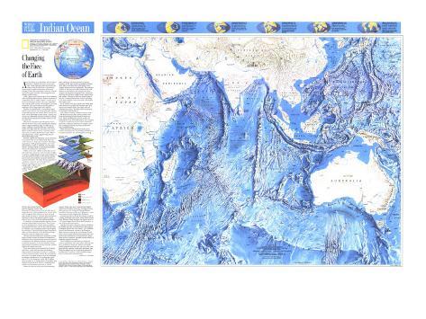
About 50 million years ago India, then an island continent, collided with Asia. At the same time, a new Hawaiian island first broke the waves of the Pacific Ocean, and western North America ripple with pulses of mountain building. These diverse geologic events are all manifestations of plate tectonics, the driving force that changes Earth's surface.
Earth's rocky crust is broken into 20 or so massive slabs called lithospheric plates. Each is composed of continental rocks or seafloor basalt, or both, and portion of the upper mantel. The cold, rigid plates ride atop the partly molten asthenosphere (layer of Earth that lies at a depth 6050 mi (10050 km), shuttling continents and ocean basins around the globe in response to heat rising from Earth's interior.
Seafloor is created at rifts, or spreading centers, where the crust below the ocean pulls apart. Molten basalt wells up from the interior, flows onto the seafloor, cools, and bonds to older bands of crust on either side.
Movement along these spreading zones cracks and tilts blocks of crust, thus shaping and reshaping Earth's longest mountain range, the Mid-Ocean Ridge. Snaking around the globe of 74,000 kilometers, the ridge splits the ocean floor into basins. Where seafloor creation is last, a smooth, broad slope such as the East Pacific Prise results. Where spreading is slow, a steep, jagged range like the Mid-Indian Ridge forms.
Because Earth is not expanding, ocean crust must be recycled. Old, heavy seafloor skins back into Earth's interior at deep ocean trenches. The plunging seafloor, which gradually pulls the rest of the plate behind it, skins, or subducts, into the upper mantle. Volcanic islands or mountain chains then rise, fed by melting rock from below.
Unlike ocean crust, which is continually created and destroyed, continental crust is usually too light to subduct. Originating as a small nucleus billions of years ago when the surface of the molten Earth began to cool, each continent has grown with the accretion of new land. The oldest known fragments of a primitive continent, now in the heart of Western Australia, are tiny crystals dating back 4.3 billion years.
In contrast, the oldest seafloor basalts, recently found in the western Pacific near the Mariana Trench, date back only 175 million years. Each new injection of magma into the crust is magnetized as it cools. Since Earth's magnetic field is known to have reversed many times, the dates of reversals allow scientists to calculate the age of the seafloor and the rate at which it moves away from the Mid-Ocean Ridge.
Earthquakes accompanying late motion are concentrated along ridges and trenches. These bands of Earth-shaping activity define plate boundaries. Great transform faults, like the san Andreas Fault in California, are zones where plates slip and grind by each other. Transform faults connect trenches to ridges and link segments of the Mid-Ocean Ridge, giving the range an alligator-like texture.
Plate tectonics has shifted the continents, or fragments of them, around the planet for hundreds of millions of years. An ocean may form in the heart of a continent as the landmass splinters, its pieces sent in opposite directions, in the way that the ancient supercontinent of Pangaea broke up when the Atlantic opened 180 million years ago.
When the Indian Ocean opens 10 to 20 million years later, a new plate was born. its northern edge consisted of a portion of seafloor, asediment-covered continental shelf, and the flat, old subcontinent itself. Eventually India broke free of Madagascar and sped northward at the geologically rapid rate of 15 to 20 centimeters a year. By 50 million years ago the plate's ocean floor had subducted benearth Asia, India's continental shelf collided with the massive bulwark of Eurasia.
Chains of volcanoes rose above the subducting plate, and huge sub-surface masses of granite welled up beneath southern Asia. Bits of old ocean floor were trapped between the two landmasses. The contiental shelf of India was soon forced below Asia, and thick layers of sediment and rock were scraped off and plastered against Tibet. The Himalaya rose as successive wedges of rock stacked atop one another. Heating in the stack melted some of the rock, forming other granite masses, including 8,481-meter Makalu, now on the crest, world's fifth highest peak.
By 28 million years ago the Indian landmass above the waterline had rammed Asia. Sediments washed off the new range onto the underthrusting plate. The folded layers now form the foothills of the Himalaya.
The collision continues. India has driven some 2,000 kilometers into Asia, shoving Tibet to the north and boosting it five kilometers above sea level. China and Mongolia squeeze to the east. Although the Indo-Australian plate is now creeping at only five centimeters a year, layers continue to peel away, raising the Himalaya ever highter. Each new earthquake releases the strain of the continent's underthrusting.
While India was rafting toward the Equator, another tectonic process was building mountains on the island continent. An isolated plume of rising magma, called a hot spot, broke through India's crust about 65 million years ago. Enormous floods of lava poured out, raising the Deccan Plateau. Lava flows there are as thick as 2,400 meters–more that a quarter of the height of the Himalaya.
As India moved away from the hot spot, a trail of volcanic seamounts rose on the young Indian Ocean floor. Reunion Island now lies over the not spot. It's 2,631-meter-high volcano, Pinton de la Fournaise, is one of the world's most active.
Strands of hot-spot volcanoes, such as the Hawaiian Islands and their eroded relatives, the Emperor Seamounts, blister the ocean basin. The 70-million-year-old northernmost volcano of the Emperor chain is poised to plunge into the Aleution Trench. Other massive seamounts and subsea plateaus await an uncertain destination as the plates move about. Many will be scraped of the seafloor and added to a landmass as plates converge.
Tens of millions of years from now India will cease to underthrust Asia. New plates will form and move in different directions. Eastern Africa has already begun to separate from the rest of the continent and may someday collide with southeast Asia. While the impact may not equal the magnitide of the Himalaya's creation, it will certainly reshpe today's ocean basins and continents.