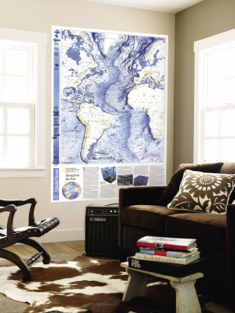
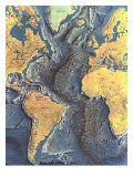
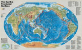
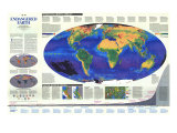
CONTINENTAL MARGINS: Submerged land between shore and ocean basin, including the continental shelf, slope, and rise. Most ocean plants and animals live in the shelf's shallow, sunlit waters.
TRENCHES: Formed when dense oceanic crust slides beneath lighter oceanic or continental crust. The Mariana Trench, Earth's deepest, plunges nearly 11 kilometers benearth the Pacific's surface.
SEAMOUNTS: Active or dead underwater volcanoes rising at least a thousand meters above the seafloor. Those that penetrate the surface become islands, such as the Hawaiian chain.
ABYSSAL PLAINS: Develop in areas of high sedimentation, such as just off continental margins. These extensive, featureless regions of the ocean floor constitute Earth's flattest surfaces.
RIDGES: Underwater mountain ranges cleaved at right angles by fracture zones. The Mid-Ocean Ridge, Earth's longest mountain chain, winds 74,000 kilometers (nearly 46,000 miles) around the globe.
DIVING INTO OUR PAST - Ever since the fourth century B.C., when Aristotle wrote of snorkels and diving caldrons, human curiosity has led ever forward to new inventions for exploring the sea. Leonardo da Vinci made drawings for underwater breathing devices in the 15th century. True diving bells followed in the 16th and 17th centuries, enclosed barrels in the 18th century, and submarines and hard-hat diving suits in the 19th century.
With the invention of the Aqua-Lung by Jacques-Yves Cousteau and Emile Gagnan in 1943, people could at last move and work freely beneath the water. Such dives, however, are limited to shallow waters: In the first shipwreck site excavated using scuba gear, off Marseille in 1952, Cousteau and his team were able to work to a depth of 45 meters (150 feet). The “underwater dig,” as undersea archaeology has been called, had been born.
For that and similar projects, Cousteau's team emplyed many tools still used today for underwater excavation: the lift basket, to carry objects to the surface; the air lift, a suction-hose “vacuum cleaner”; and the Galeazzi water jet, a device that clears away sediment.
In 1958 Italian archaeologist Nino Lamboglia introduced a grid system to survey an ancient Roman wreck of Sardinia. Underwater investigators have since been able to measure sites and photograph artifacts in their precise context, just as archaeologists do on land.
The archaeologist-diver first appeared on the scene in 1960, when George Bass, founder of the Institute of Nautical Archaeology at Texas A & M University, undertook the excavation of a Late Bronze Age ship off southwestern Turkey. since then nautical archaeologists have excavated more than a humdred sunken ships, not only showing how they were constructe but also revealing details about their sizes, cargoes, and shipboard life.
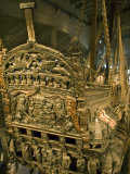
One of the most completely preserved ships ever recovered is the Vasa, the famous Swedish man-of-war that sank within an hour of her launching in 1628 in 33 meters of water in Stockholm harbor. The ship was lifted whole by the use of cables and pontoons in 1961 by Anders Franzen. The long restoration process of the elaborately carved wood ship was served as a laboratory experiment over the years for the underwater conservation scientist.
But the study of ancient ships is only part of the story of underwater archaeology. Excavations in the ancient harbors are revealing a wealth of knowledge about past technology, trade, and economic history. Such investigations usually begin with aerial photography, as pioneered in the 1930s and '40s by the Jesuit priest A. Poidebard in his studies of the ports of Tyre and Sidon on the coast of Lebanon. In 1965, by combining such coverage with underwater and land excavation, the port of Cosa, one of the earliest known Roman harbors, along Italy's Tuscany coast was uncovered. Dating from 273 B.C., Cosa served as a hub for the export of fish sauce and wine for more than 200 years.
The most important technical devices now used by underwater archaeologist for locating ships or harbor features that cannot be seen are the side-scan and sub-bottom profiling sonars perfected by Harold Edgerton of the Massachusetts institute of Technology. The side-scan, in conjuction with a magnetometer, uses reflected sound waves to sweep laterally over large areas of the ocean floor. Sub-bottom profiling sonar “sees” directly below th surface, but it can cover only a limited area.
In 1963 Edgerton used side-scanning sonar to dramatically reveal the wreck of the Vineyard lightship which sank in 1944 of Massachusetts in 25 meters of water. In 1968 Edgerton revealed much of the sunken city of Port Royal, Jamaica, destroyed by earthquake in 1692. He also helped locate the famed Civil War ironclad Monitor, which foundered in 70 meters of water off Cape Hatteras in 1862.
Computers now enable underwater archaeologists to perform tasks ranging from the plotting of artifacts to the building of data bases. A recent breakthrough is the computer-controled sonic high accuracy ranging and positioning system, or SHARPS, developed in 1984 by Martin and Peter Wilcox of Applied Sonics Corporation, which allows fast, accurate, three-dimensional acoustical mapping of any underwater site. With SHARPS the archaeologist can have instant visual verification on the computer screen of the coordinates of any point. At present SHARP'S range is limited to a a hundred meters, but the system promises to revolutionize both shallow-water and deep-sea research.
Deep-sea archaeology is being aided today by the use of sophisticated unmanned submersibles, or remotely operated vehicles (ROVs), such as Jason, built by Robert D. Ballard and his team of engineers at the Woods Hole Oceanographic Institution. Tethered to a submersible platform by a cable, the two-meter-long jason can cruise as fast as one knot an hour and as deep as 6,000 meters with precise maneuverability. It carries three high-resolution color video cameras, a 35-millimeter still camera, and high-intensity lights.
The Jason Project, in May 1989, traced an area of about 50 square kilometers at the depth of 800 meters below an ancient rea-trade route between Rome and Carthage. Using Jason's manipulator arm amphorae and other delicate artifacts from a late Roman wreck site were raised.
More than 98 percent of the world's ocean bottoms remain unexplored, but robot technology has the potential to take us across that final frontier of knowledge of Earth and its rich past. With that new technology, archaeologists can record data from great depths and learn without excavation–and without personal risk. They can reconstruct ancient pattern of trade and commerce and elicit new data on the vessels and the people who sailed them. ...