|
|
|
|
|
|
|
|
|
|
|
|
EAST COAST
TEACHING RESOURCES
|
|
|
|
|
|
|
|
|
|
|
|
|
|
|
|
|
|
|
 |
|
|
|
|
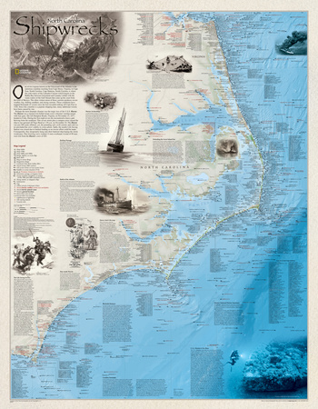
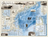
Shipwrecks of the Outerbanks Poster Map
for social studies classrooms and homeschoolers
|
geography > North America > United States > SHIPWRECKS OF THE OUTER BANKS MAP < history < social studies < maps
|
The Shipwrecks of the Outer Banks features:
• location of over 1,550 shipwrecks of the Atlantic Coast from Cape Henry to Cape Fear
• class, type and name of vessel accompanied by the date of sinking
• bathymetric and coastal detail
* Lesson plan idea - have your students update the information and latest statistics concerning the Outer Banks; discuss, contrast and compare the political, economic (employment), and environmental (climate change) situations of the area.
One of two regions known as the Graveyard of the Atlantic is the notorious coastline reaching from Cape Henry, Virginia, to Cape Fear, North Carolina. Cape Hatteras, North Carolina, is where the cold waters of the Labrador Current (which begins in the Baffin Bay between Greenland and Canada) collide with the warm waters of the Gulf Stream that come up the coast from the Gulf of Mexico. The often violent union of these currents produces severe weather, fog, shifting sandbars, and strong currents. These conditions have trapped thousands of vessels since the first recorded sinking off Cape Fear in 1526. Since this coastline is a popular shipping lane, many additional wrecks have been caused by war.
Perhaps the most dramatic disaster was the tragic loss of the U.S.S. Huron. The Huron was a masted iron-hulled steam crew schooner warship armed with four guns. She left Hampton Roads, Virginia, of November 23, 1877, headed to Cuba. During her first night at sea she encountered a heavy gale blowing from the southeast. This severe storm plus a compass error caused the ship to run aground off Nags Head at 1:30 a.m. on November 24. The Huron was just 200 yards offshore; yet, the pounding surf, swift current, and cold water precluded the crew's ability to swim ashore. Sadly, the nearby Life-Saving Station was closed due to limited funding so no rescue effort could be made. Consequently, they desperately hung onto their batter ship hoping the storm would pass. One towering wave washed 12 men overboard. A total of 98 men were lost from the Huron's crew of 202.
Marine Archaeology
A small handful of artifacts recovered from the beach near Currituck Beach Lighthouse over the past decade has helped date the oldest shipwreck yet located in North Carolina to the mid-17th century. Shipwrecks, particularly older ones, provide a unique opportunity for nautical archaeologist, using modern computer-based technology and increasingly sophisticated an alytical tools, to fill gaps in our collective historical record. Whether the advent of modern naval power represented by U.S.S. Monitor or the swashbuckling excitement of Blackbeard's flagship Queen Anne's Revenge, virtually all shipwrecks and their associated artifact assemblages have a story to tell about the continued development of mankind and his interaction with the world's navigable waterways.
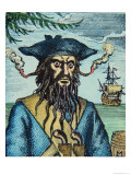
Queen Anne's Revenge
Many a buccaneer sailed the Carolina coast during the “Golden Age of Piracy”; yet, none were as infamous as Blackbeard, Edward Teach appeared in the Caribbean in 1716 and the following year secured the French slaver Concorde. Blackbeard armed her with 40 cannons and re-christened her Queen Anne's Revenge.
Edward Teach then set off on a brief career which would awe many of his fellow “Bretheren of the Caoast.” While noted for his daring and courage, he had a commanding presence and a reputation for evil, which made many believe that he was in league with the devil or perhaps was the devil himself. He was a tall, broad-shouldered man and gained his nickname from his large black beard which had grown to an extravagant length and reached up to his eyes. He wore it twisted with ribbons and wore lighted matches under his hat on each side of his face. This made him look fierce and wild as if he was a frightful fury from hell.
Blackbeard amassed a fowerful force of four ships mounting 70 cannons with a compliment of 300-400 men. His greatest success was Blackbeard's blockade of Charleston, South Carolina. He then sailed to the North Carolina sounds. As two of his ships, Queen Anne's Revenge and Adventure, made their approach into Beaufort, the vessels ran hard aground and were wrecked. Blackbeard, aboard a smaller sloop, stripped the other ships of their treasures and sailed to Bath to obtain a pardon. Yet, he just could not stay away from piracy which promted Virginia governor alexander Spotswood to send an expedition that resulted in Blackbeard's death on November 22, 1781.
Perilous Passage
The Carolina coast was especially hazardous for sailing ships. The wind power that gracefully moved them along the coast could quickly turn violent and blow them without warning onto the shore. These handsome ships were powerless to stop a storm's force. Vessels like the schooner Saint Nicholas, which floundered on Frying Pan Shoal on February 7, 1916, carried coal, lumber, fruits, bricks, phosphate, and other valuable goods up and down the coast. Yet, many of these vessels met a tragic conclusion to their careers along the Outer Banks. As the Dorothea L. Brinkman's master's mate wrote in his final log entry after his vessel struck the beach in a heavy wind on March 22, 1924, “So this day ends in grief.”
While these wrecks were horrific, the stranded vessels were salvaged in a manner that benefitted the ship's owners as well as many Outer Banks communities. The four-masted schooner G.A. Koehler of Baltimore en route to Haiti to obtain a load of logwood was stranded high up the beach north of Little Kinnakeet Station during the infamous August 22, 1933 hurricane. Even though the schooner's owners stripped the vessel of all useful material such as rigging, sails, navigational lights, and whatever else could be saved, the locals would then salvage the rest of the hulk. Timbers from the G.A. Koehler were used to build the Assembly of God Church in Salvo, North Carolina. The schooner's abandoned hull would eventually be burned to harvest its iron during World War II. All that is left now of this once graceful craft are some timbers embedded in the sand.
Battle of the Atlantic
When the United States entered World War II, one of the keys to victory was how the “Arsenal of Democracy” could effectively transport men, food, oil, weapons, and other war material to Europe. The German navy immediately recognized their need to block this trade and brought the Battle of the Atlantic directly to America's vulnerable coastline within weeks of the war's eruption.
During World War I, German submarines rarely reached the American shoreline. The U-140 did sink the Diamond Shoals Lightship No. 71 by shell fire on August 6, 1918. In early 1942 the German wolf packs struck along the Outer Banks with a vengeance. On January 18 the U-66 torpedoed the tanker Allan Jackson. She split in two and quickly went under. The U.S.S. Roe was able to give assistance; however only 13 of 35 men were saved. These submarines also struck at merchant ships with their deck guns and mines. The tanker Panam developed engine trouble and straggled behind her convoy on 4 May 1943. This was all the U-129 needed to attack. The Panam was struck by one torpedo in her engine room killing two seamen. Another torpedo struck a few minutes later and the tanker was abandoned. The 49 survivors were rescued by the U.S.S. SC644. The U.S.C.G.S. Icarus depth charged and sank the U-352 on May 9, 1942. The U-boat had attempted to torpedo the Icarus. The torpedo exploded prematurely which alerted the Icarus to the submarine's presence. The cutter rescued all but 13 of the U-352's crew. The submarine threat eventually vanished by the end of 1943.
Defending the Great Inland Sea
Control of the North Carolina sounds became a priority for North and South alike when the Civil War erupted. Confederate privateers and gun boats would often dash out of Hatteras Inlet to capture Northern merchant ships until forces under the command of Flag Officer Silas Stringham and Major General Benjamain Franklin Burtler captured the forts guarding the inlet on August 29, 1862. On January 1872, Major General Ambrose E. Burnside and Flag Officer Louis M. Goldsborough assembled an armada to attack Roanoke Island. Burnside's 13,000-man command were shipped south by a motley collection of over 60 ships escorted by Goldsborough's 20 warships. The flotilla encountered a heavy gale shortly after leaving Hampton Roads the raked the ships in a horrific fashion. One transport, the City Of New York, floundered of Hatteras Inlet on January 13. The crew hung onto their stranded craft for 40 hours before being rescued. The fleet encountered yet another storm before they could cross the Oregon Inlet bar and enter the sounds. Roanoke Island was defended by three forts and two canal boats lashed together with walls of sand bags and cotton bales. Known as Fort Forrest, the barges had been pushed onto the shore and armed with seven cannons. In addition to these forts there was the eight-ship North Carolina Squadron known as the Mosquito Fleet. These ships had a total of 9 guns agaisnt the 50-heavy guns in Goldsborough's fleet. On February 8 the two squadrons exchanged long-range fire as Union troops landed on Roanoke Island. The C.S.S. Curlew was hit below the waterlien and ank. The rest of the Mosquito Squadron fled up the Pasquotank River to Elizabeth City. Union gunboats followed the Confederates and, on the morning of February 10 attacked. The C.S.S. Sea Bird was sunk while the C.S.S Black Warrior, C.S.S. Ellis, and C.S.S. Fanny were burned by their crews. Only the C.S.S. Appomattox and C.S.S. Beaufort escaped. Unfortunately, the Appomattox was two-inches too wide to enter the Dismal Swamp Canal and was scuttled at the South Mill lock's entrance.
Manmade Wrecks
Wrecks still occur today along this treacherous coast; however, most are now caused by man not nature. Since the beaches from Cape Henry to Cape Fear have become popular for various recreational activities, many an old worn-out vessel have been sunk to create artificial reefs. Initially intended to enhance fishing, these wrecks have become popular diving sites. The Liberty Ship U.S.S. Alexander Ramsay was sunk off of Masonboro Inlet, North Carolina, in just 45 feet of water and has become a favorite site for many a novice diver.
The Priscilla was hard aground and split in two. The crew–not able to see where they were due to thick fog–cried out for help. Admist all this misfortune a savior arrived. Surfman Rasmus S. Midgett of the Gull Shoal Station was on horseback patrolling the beach when he noticed debris along the shore. Then he heard the cries of the crew. Midgett knew he did not have time to get assistance, so as the waves poured over the strand he entered the surf to get as close as possible to the wreck. He ordered the survivors to jump overboard one at a time and through the pounding waves to safety on a dune. He actually had to carry three of the ten survivors ashore In recognition of his bravery and courage Midgett was awarded the Gold Lifesaving Medal of Honor.
Ill-fated ships lie forever anchored in the coastal sea floor. 1500 wrecks, from the British Tiger, sunk in 1585 in Ocracoke Inlet, to the fishing trawler Orient, lost in 1969 off Bodie Island Lighthouse. Many vessels went aground in fog or storm. Wars took a further toll: Federal and Confederate gunboats battle to the finish, World War I U-boats sank many vessels, including the Diamond Shoals lightship, and Nazi submarines in World War II torpedoed freighters and tankers.
|
|
|
|
previous page | top
geography > North America > United States > SHIPWRECKS OF THE OUTER BANKS MAP < history < social studies < maps
|
|
I have searched the web for visual, text, and manipulative curriculum support materials - teaching posters, art prints, maps, charts, calendars, books and educational toys featuring famous people, places and events - to help teachers optimize their valuable time and budget.
Browsing the subject areas at NetPosterWorks.com is a learning experience where educators can plan context rich environments while comparing prices, special discounts, framing options and shipping from educational resources.
Thank you for starting your search for inspirational, motivational, and educational posters and learning materials at NetPosterWorks.com. If you need help please contact us.
|
|
|