|
|
|
|
|
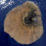
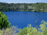
The Galapagos Islands were formed by a “hotspot” in the East Pacific Ocean near the equator and Fernandina Island is the youngest of the Galapagos Islands.
|
|
|
|
Pico do Fogo, or Peak of Fire, is is the highest peak of Cape Verde, an island nation in the Atlantic Ocean.
Pico do Fogo is an active stratovolcano creating the island of Fogo. The main cone last erupted in 1675, a subsidiary vent erupted in 1995 which caused the destruction of Chã das Caldeiras, a small village inside the caldera.
Fogo is known for the coffee that grows on the mountain slopes.
FYI - “Fogo” is Portuguese for “fire”.
|
|
|
|
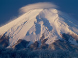
Mount Fuji, an active volcano with a low risk of eruption, is the highest point in Japan and its national symbol. The high altitude cloud in this image is called lenticular.
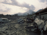
Japan's Unzen volcano erupted in 1991 claiming the lives of 43 scientists and journalists. Unzen is designated as one of the 16 Decade Volcanoes. |
|
|
|
Galeras stratovolcano in southwestern Colombia near the city of Pasto, is one of sixteen Decade Volcanos. The list of volcanoes are those considered most dangerous due to “their history of large, destructive eruptions and proximity to populated areas”.
|
|
|
|
Mount Gambier, a maar complex in South Australia, formed only about 4,900 years ago.
It is associated with the Newer Volcanics Province and a part of the UNESCO-endorsed Kanawinka Geopark.
|
|
|
|
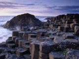
Giant's Causeway in Ireland is made up of 40,000 interlocking basalt columns, the result of an ancient volcanic eruption.
During the Paleogene period, 50 to 60 million years ago, the area of Antrim was the site of intense volcanic activity, when very fluid molten basalt intruded through chalk beds to form the Thulean Plateau.
The columnar basalt in Yellowstone and the columns on the Island of Staffa, Scotland, were formed in the same process.
|
|
|
|
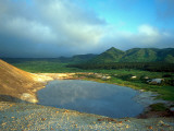
Golovnino, a caldera located in the southern part of Kunashir Island, Kuril Islands, Russia, is named after Russian explorer Vasily Golovnin (1776-1831).
|
|
|
|
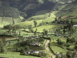
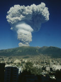
Guagua Pichincha an active stratovolcano in Ecuador, whose capital Quito wraps around its eastern slopes.
|
|
|
|
|
|
|
|
|
|
|
previous page | top | next
volcanoes > a | b | c | d | e | F-G | h-i-j | k | l | m | n-o | p | q-r | s | t | u-v | w-z < mountains
|
|
I have searched the web for visual, text, and manipulative curriculum support materials - teaching posters, art prints, maps, charts, calendars, books and educational toys featuring famous people, places and events - to help teachers optimize their valuable time and budget.
Browsing the subject areas at NetPosterWorks.com is a learning experience where educators can plan context rich environments while comparing prices, special discounts, framing options and shipping from educational resources.
Thank you for starting your search for inspirational, motivational, and educational posters and learning materials at NetPosterWorks.com. If you need help please contact us.
|
|
|