* Lesson plan idea - have your students update the information and latest statistics concerning the state of Maine in the United States and the Canadian Maritime Provinces of New Brunswick, Nova Scotia and Prince Edward Island; discuss, contrast and compare the political, economic (employment), and environmental (climate change) situations of the area. • maps
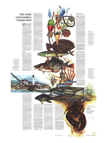
Sea-swept coves beside a forested realm
Maine and Canada's Maritime Provinces may be separated by an international boundary, but they share similarities of geography, climate, an history. The Appalachian chain that marches northward through Maine submerges in the Gulf of St. Lawrence. And where world-record tides surge in the Bay of Fundy, piers on both sides of the border perch stiltlike heights above the water.
The adjacent Atlantic Ocean influences weather patterns, underscoring the label “maritime” (1. Of, relating to, or adjacent to the sea. 2. Of or relating to marine shipping or navigation). Along the coast, fog sets the mood where warm Gulf Stream waters meet those of the cold Labrador Current. Rugged storms called northeasters may keep trawlers in port, but dump a welcome blanket of snow on inland ski resorts.
Here early explorers came looking for a northwest passage to the wealth of the Orient; instead they found one of the world's richest fishing grounds. Frenchmen built a profitable fur trade among the Indians and called the region Acadie. The English coveted the tall pines of the Acadian forest for ship's masts. Shattering the French dream of a New World empire, they bestowed many of the names we know today.
Road signs and tourist brochures in English and French announce that parts of the region are bilingual. Acadian fishermen and farmers lend a flavor of France to coastal towns, these descendans of the region's earliest white settlers will be pleased if you try their language, but English is understood everywhere.
Border crossing is uncomplicated*, but you'd be wise to carry such identification as passport, birth certificate, or voter's registation card. Most Canadian businesses accept U.S. currency, but you'll be sure of getting official rates by exchanging your money at a bank.
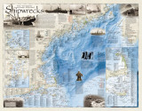
On fingering headland and rocky shoal lighthouses dot Maine's coast – boons to seamen and subtle challenges to camera lens or artist's brush. One, Portland Head Light, has stood singe 1791. President George Washington authorized its rubblestone tower and $160-a-year salary for its resident keeper. Tales of the heroism and devotion of lighthouse tenders are legion. One keeper, a woman, pounded a fog bell for 20 hours when automatic machinery broke. Another took only two days off in 23 years – and one of those he used for getting married.
MAINE -
Maine turns two faces toward the traveler. Along its renowned Atlantic coast, surf pounds against granite shores and the sea intrudes in the hundred harbors. Across the state's northern reaches poke a forested profile of mountains and highlands spangled with rivers and lakes.
Three of four Maine vacationists succumb to the call of the rock-clad coast. Travelers sniff the salt air as they twist their way along shore-hugging U.S. 1. Car windows frame scenes of wave-washed headlands and half-hidden coves. But inland the salt tang gives way to the scent of pine and to isolated realms that have been called “the last wilderness frontier in the East.” Here newcomers find room to roam; Maine has an area nearly equal to the five other New England states, but holds fewer than a tenth as many people.
Fishermen, hikers, rockhounds, and canoeists head for the north woods, wheeling their campers and trailers along U.S. 201 and State 11 and 15. Anglers seek such spots as 40-mile-long Moosehead Lake; they take brook trout and landlocked salmon, and lake trout known throughout Maine as togue. Many mountain resorts stay open year round, ofering vacation packages for the whole family: boating and backpacking in summer, skiing and snowmobiling in winter. Bush pilots strap canoes to their floatplanes and fly outdoorsmen even farther into the back-country from such bases as Greenville.
Few town named dot the map in northwestern Maine. In this lonely landscape pulp and paper companies harvest legions of logs that make forest products the state's economic mainstay. Some 2,000 miles of logging roaads – unpaved but graded roadways open to the public – lace the region. Regulations for their use vary; fees are charged on some, on all of them logging trucks have the right-of-way. Be sure to fill your gas tank before entering at a check-point. And ask about backwoods road maps; signs are scarce on these wilderness byways and taking the wrong fork can cost you hours.
Other wilderness tests await the enthusiast. Mount Katahdin, highest peak in Maine, attracts hikers to Baxter State Park. A former governor donated some 201,000 acres to make Baxter the largest park in the state. Even unpracticed trail buffs can trek to the 5,268-foot summit and back on a day's outing.
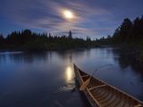
Canoeists get their big challenge on the Allagash Wilderness Waterway. Early July usually sees water levels at their best, but as a rule you'll encounter fewer insects and better weather later on. The 98-mile trip from Telos Landing to the village of Allagash on the St. John River challenges paddlers with choppy lakes, rapids, and at least three portages. ...
Interstate 95 angles across Maine, threading watery mazes and green uplands. At Brunswick, Augusta, and Bangor you successively encounter the state's three largest rivers – the Androscoggin, Kennebec, and Penobscot. Down these river roads from the interior lumberjacks in the 1800s floated logs to sawmills and waiting schooners. Loggers with money in their pockets and pleasure on their minds turned on section of Bangor into the “Devil's Half Acre," now only a lurid memory.
Today agricultural calm replaces brawling river drives. Poultry farms dot the landscape and dairy cattle graze near white-frame towns. The fertile fields of huge Aroostook County across the state's northern tip bloom in summer and in autumn yield 90 percent of Maine's vaunted potato crop.
Uncounted inlets nd peninsulas serrate a land chewed by Ice Age glaciers; the 228 miles from Kittery to Calais as the gull flies becomes 3, 478 miles of twisting shoreline. Motorists skirt the indentations on U.S. 1 as they head for international ferries at Portland and Bar Harbor, or for a border crossing into the Maritimes.
Portland dominates the state's southwestern corner, where more than a third of Maine's population and many of its industries cluster. From ferry slips on the city's waterfront, ships leave twice daily during the summer season for the ten-hour cruise to Nova Scotia. You'd be wise to make reservations for berths if you plan a nighttime crossing.
Bath reflects an era when shipwrights fashioned Maine lumber into fleets of sailing ships, including that three-masted workhorse, the down easter – sturdy, fattened-out successor to the sleek clipper. Young visitors to the Bath marine museum can see ship models or clang away on a real ship's beel in the “Please Touch” room. Along tree-lined streets in such towns as Wiscasset, Thomaston, and Searsport stand homes built by the cptains who once sailed the white-winged vessels.
If you want to thrill to bulging sail and singing rigging, take a week's windjammer cruise out of Camden to explore Penobscot Bay and beyond. Neophyte sailors haul on lines as they work up an appetitie equal to the challenge of steaming bowls of the captain's own chowder, served with oven-fresh bread, and the sating touch of luscious blueberry pie.
Summer weeks along the coast fill with activities. Antigue auctions lighten a visitor's wallet while cleaning out local attics. Restaurants – some of them old stagecoach inns – may feature Maine lobster but use a pencil to fill in the current price on the menu. Church suppers dispel the myth of the taciturn State-of-Mainer.
Boats take tourists to offshore islands for sumptuous New England clam-bakes. There are fishing craft for charter, chill waters for hardy swimmers to dip into a beach or cove, sidewalk art festivals and agricultural fairs to browse through, and, of course, a liberal sprinkling of summer stage productions.
As a contrast to Maine's seashore and greenery, at Freeport you can tread the dunes of a strange desert. Sands left behind by an ancient glacier have engulfed 300 acres of farmland and buried two small farm buildings. Restless winds power the steady march.
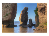
Winds also power the waves crashing against a panorama of high headlands that fasincates nature lovers at Acadia National Park on Mount Desert Island. You can sample the park's wonders in a number of ways: Prowl the rocky tidal zone at low water. Join a naturalist for a cruise along the shoreline. Wander into the fragrant woods. Hike, bicycle, go horseback, or take carriage rides. Or drive park roads with a rented tape machine whose commentary tells of attractions at salient turns. One road climbs to the pink granite summit of Cadillac Mountain. Suddenly you are rewarded; a breathtaking view of sparkling water and rugged rock, where dawn's rays pick out the highest point along the nation's eastern coast.
NEW BRUNSWICK -
During the Loyalist Days each July in Saint John, costumed “settlers” step ashore once again at waterfront-redolent Market Slip. The pagentry recalls days during and after the Americn Revolution when 14,000 Tories fled to New Brunswick from the Colonies.
Alomst overnight these energetic Loyalists boomed Saint Johnn from a frontier seaport into the business center it remains today. Many of the exiles migrated up the St. John River Valley to carve out farms on land grants from Britain's king.
You can follow their footsteps as you drive the Trans-Canada Highway past Loyalist farmsteads. Rows of potato plants, ripening truck crops, and apple orchards await the harvest. In spring, in marshy glens Malecite Indian families gather fiddlehead ferns; these tender wild greens, a New Brunswick specialty, grace many a dinner menu. And at many spots you can buy bags of dulse, a dried seaweed to be munched like potato chips.
Fredericton, the capital, mixes 20th century buildings with Victorian mansions. it mixes too art and letters–official designation as the “Poet's Corner of Canada” for the work of its writers, and such art repositories as the Beaverbrook gallery, one of several gifts to the city by New Brunswicker Max Aitken, London press lord and financier.
Fifteen miles from Fredericton you cross the river atop Mactaquac dam. Its 60-mile-long head pond brought new boating marinas and bathing beaches; its electricity powers an economic resurgence with energy for smelters and pulp and paper mills.
Deer, bear, moose, and beaver roam along conifer-banked streams of the central highlands. So do fishermen seeking that great game fish, the Atlantic salmon. Wealthy sportsmen make reservations a year ahead at popular fishing camps and clubs along the Restigouche and Miramichi Rivers.
Towns with French names harbor commercial fishing boats along the eastern coast. Beret-topped French Acadians unload the day's catches, then head home to tidy cottages. Visitors can find cozy restaurants where they choose their own live libster and have it cooked.
In Moncton, New Brunswick's second largest city, new office buildings rise. But the nearby Bay of Fundy humbles such man-made achievements. Twice each day a hundred billion tons of water surge into this narrowing bay. Best place to view these tides is at Hopewell Cape, where the water's ceaseless action has carved fantastic shapes in the red sandstone cliffs.
NOVA SCOTIA -
Wary of another winter in the New World, Samuel de Champlain in 1606 proposed an antidote for the boredom that threatened the infant post of Port Royal. Let each adventurer in turn provide a gourmet dinner from the land's bounty. As steaming dishes of moosemeat pie and breast of goose came to the table. Champlain proclaimed the Order of the Good Time.
You can step into those frontier days at reconstructed buildings of the settlement. And you can join Champlain's bon vivant order if you spend at least three days in Nova Scotia; ...
Ferries from new Brunswick land vacationists near this bit of Canada's past. And at the opposite end of the province looms another: redoubtable Louisbourg, a bastion built to guard the settlements and fisheries of New France. Captured by Britain in 1758 and then demolished, it now is being reconstructed: costumed guides people the fortress-city. At Grand Pre a statue of Longfellow's Evangeline commemorates Acadians expelled by the British.
But French still sounds in the ethnically varied province. So does German-accented English around Lunenburg, which savors its shipbuilding tradtion. Irish touches color Halifax – the capital whose bustle contrasts with quiet villages sporting such lilting names as Ecum Secum and Mushaboom.
Gaelic immigrants made the highlands of Cape Breton Island a place apart; at Baddeck an airy museum displays the inventiveness of one doughty Scot, Alexander Graham Bell. That village on the salty Bras D'Or lake also serves as a jumping-off spot for the Cabot Trail, a 184-mile drive acclaimed as one of the most stunning in Canada.
PRINCE EDWARD ISLAND -
Cradled in the southern reaches of the gulf of St. Lawrence, Prince Edward Island unfolds a quilt of greening field over most of its gently rolling terrain. Deep red soil, plentiful rainfall, and long growing season nourish bumper crops in the Delaware-size province, Canada's smallest.
A geometric network of 1,800 miles of paved roads delineates farm borders. Those roads follow lines laid down in 1765 by a survey dividing the island into lots assigned to absentee British landlords. Not until a century later were the last of these plots opened to purchase by tenant farmers. Today farm vacations let you sample rural life and feel the islander's love for his land.
Around the island's edge, fishermen farm the sea. Lobsters rate high, but delectable oysters thrive in Malpeque and other bays, clams spurt in mud flats at low tide, and Irish moss raked from the seabed becomes raw material for a stabilizer used in ice cream, toothpaste, and many other products.
Camping lures thousands to “P.E.I.” as everyone calls the island. Most find their way to Prince Edward Island National Park, a 25-mile sweep of dunes and gentle surf along the north coast.
Charlottetown, P.E.I's capital, offers doubledecker buses for sight-seeing past such landmarks as Province House. Here colonial representatives gathered in 1864 for a meeting that led to Canada's union as a confederation. Now a showcase confederation Centre of the Arts commemorates the event and draws appreciative throngs. The island is reached only by boat or plane; be prepared to cope with ferry queues and flight reservations.
[• Lucy Maud Montgomery, author of Anne of Green Gables, was from P.E.I.]