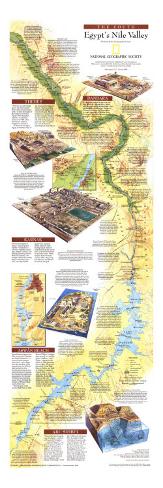
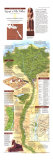
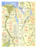
The 1995 Nile Valley South map features:
• Modern cities, highways, railways, and airports
• An abundance of historical sites including submerged sites
• Insets of Thebes, Dandara, Karnak, Aswan Reach, and Abu Simbel
• Archaeological details of notable sites and the efforts made to protect them from degradation
• Facts about archaeological discoveries such as the Nag Hammadi codices
• Details of how the stones used to built the temples were mined, and quarry sites
• Insets of the Philae Temples and the Valley of Kings
* Lesson plan idea - have your students research for updated information on the archeology of the Nile River Valley • maps
THEBES - “without an order being given, the men formed their ranks and presented arms” at their first sight of the temples of Thebes. Egypt's New Kingdom capital is as inspiring today as it 1799, when Napoleon's soldiers snapped to attention.
In the heart of Upper Egypt and within reach of the mineral-rich Eastern Desert, Thebes counter-balanced Memphis, hub of Lower Egypt. The city proper (now Luxor) with its state temples stood on the east bank; the necropolis with its funerary temples and rock-cut tomgs lay west of the river ... .
VALLEY OF THE KINGS - Shortly after 1500 B.C. concealed tombs cut in rock replaced pyramid burial chambers. Almost all the New Kingdom pharaohs were buried in the Valley of the Kings, chosen perhaps because the outcrop above it resembled a pyramid. Robbers eventually looted most tombs but missed that of the boy-king Tutankhamun. Discovered by Howrd Carter in 1922, its many treasures included a wooden throne sheathed in gold and inlaid with faience, colored glass, and semi-precious stones.
DANDARA - An imposing temple to the cow goddess, Hathor – patron of joy, music, and dance as well as motherhood – lies on the fringe of the desert. Begun by Ptolemaic rulers in the first century B.C. and expanded in Roman times, the temple is lavishly decorated and unusually well preserved.
KARNAK - The Great Temple of Amun – patron god of Thebes – dominates a 250-acre complex of temples, chapels, colossi, and obelisks. With 134 columns, the temple's hall is the world's largest columnar structure, covered 56,000 square feet; painted reliefs adorn its walls. During rituals Amun's bark floated on the sacred lake, source of holy water for priestly duties. Other temples honor Amun's consort, Mut, the young god Khonsu, and Montu, an ancient war god.
ASWAN REACH - From Roman times to the 20th century the Elephantine Island nilometer – a series of stone steps at water level – gave Egyptians the measure of the annual flood. In 1902 the lake behide the first Aswan dam made nilometers obsolete and threatened numerous monuments. By the mid 1930s the dam had been raised twice, flooding the temples of Philae Island much of the year.
Work began on the Aswan High Dam in 1960. Most of Philae's temples were moved to a smaller island, Agilkia – “new” Philae – opened to the public in 1980. Three temples south of the High Dam in Nubia, one built by Emperor Augustus Caesar (30 B.C.-A.D. 14), were moved to New Kalabsha. Rock-cut tombs of the Old Kingdom are preserved on the west bank near Aswan; ancient quarries remain to the south.
ABU SIMBEL - “One of the most magnificent of temples, enriched with beautiful intaglios ... colossal figures, ” was how the Great Temple of Ramses II struck Giovanni Belzoni, the European who unearthed Abu Simbel in 1917. Four seated solossi – sandstone statues of Ramses, each almost 70 feet high – front the 3,200-year-old monolith. A smaller temple celebrates his queen, glorious Nefertari, and the goddes Hathor, To save the monuments from flooding by Lake Nasser, UNESCO launched a four-year salvage efforts in 1964. The temples and statues were cut into 30-ton blocks and reassembled 200 feet higher up.
READING THE WATERS - Egyptians became proficient at recording the Nile's summer flood, source of the silt that nourished their crops. Year after year flood levels were marked on stairways cut into rock at various points along the channel. Because the river's rise coincided with certain positions of the stars, flood-watching spurred astronomy.
DEGRADATION OF MONUMENTS - Ancient Egyptians used the summer flood of the Nile to irrigate their crops, but today the Aswan High Dam provides water for three successive plantings. The hot Egyptian sun continually draws water to the surface, where it evaporates, depositing salt crystals. When this occurs in a stone monument, the outer layers begin flacking away, a process now degrading the bases of the Sphinx, the temples of Luxor and Karnak, and other sites along the lower Nile. Proposed solutions include pumpingg out water and wrapping foundations in protective plastic.
TEMPLE ARCHITECTURE - Stone temples, which symbolized the cosmos, were often-separated from the human world by thick walls. Representing the marsh of creation, a hypostyle, or columed hall, dominated most temples. Inner rooms – perhaps evoking the stages of creation – had lower ceilings and higher floors than the main hall, which enclosed and protected them. Many temples standing today are of the Ptolemaic and Roman periods. In contrast to those monuments, nearly all traces of the mud-brick or wattle houses of ordinary Egyptians have been lost to time.
ONE PEOPLE, MANY GODS - Egyptians worshiped a pantheon of gods and goddesses, some universal, many local. Belief in the afterlife pervaded religion, and gods took the form of humans and animals. The sun god Re shone brightest in early times; Osiris, who was said to have risen from the dead to rule the underworld, took precedence by the first millennium. As representatives of the gods on earth, pharaohs were responsible for making order out of chaos.
PHILAE TEMPLES - Agilkia Island is safe ground for Greco-Roman temples, kiosks, and colonnades honoring the goddess Isis and other deities worshiped here before Christianity took hold in the sixth century. Work began on the Temple of Isis during the reign of Ptolemy II Philadelphus (185-246 B.C.). Smaller temples glorify Hathor, the Nubian god Arensnuphis, and Imhotep, archtect of King Djoser's Step Pyramid.
RISE OF EGYPTOLOGY - Discovery of the Rosetta Stone in 1799 spurred modern Egyptology. In 1858 French scholar Auguste Mariette founded the Egyptian Antiquities Service, partly to stem export of artifacts. British archaeologist Sir W. M. Flinders Petrie, working in the late 1800s, pioneered systematic excavation of sites. By the early 20th century French, German, and American expeditions were investigating every facet of ancient Egyptian culture.
SECOND CATARACT SITES - An inscription from Jebel Sheikh Suleiman – one of several sites drowned behind the Aswan High Dam that recorded Egypt's reaches into Nubia – gives details of a military expedition around 3000 B.C. The fort at Buhen was a major link in a chain of strongholds established during the Middle Kingdom.